Canada Day weekend forecast: Changeable but comfortable, with no sign of heat
One of the most anticipated holidays of the summer in Canada is fast approaching, and millions will want to know what kind of weather they can expect.
The Canada Day long weekend will be as changeable as spring, but with more comfortable temperatures for all.
MUST SEE: Cross-country low rains on all provinces ahead of Canada Day long weekend

A lack of extreme warmth will be a key theme this holiday long weekend, and a couple of provinces have a near certainty to see stellar weather for Canada Day fireworks.
Atlantic Canada
Atlantic Canada, you’ve drawn the shortest straw regarding the weather this long weekend. The positioning of the trough puts you squarely in the zone for a couple of systems to impact you. Make the most of your Saturday weather, arguably the nicest weather you’ll see with a ridge of high pressure nestled just offshore.

By Sunday, some locally heavy downpours push across the Maritimes, with even the risk of isolated thunderstorms later into the long weekend.
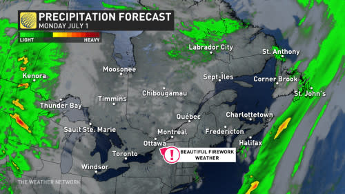
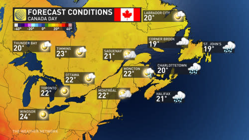
We’ll be slowly improving across the Maritimes as the frontal boundary pushes eastward during Canada Day, but Newfoundland will continue to see unsettled weather. We can’t guarantee dry conditions just yet for fireworks, but we remain cautiously optimistic for Halifax, N.S.
Ontario and Quebec
Unlike Atlantic Canada, you’re going to get your unsettled weather out of the way earlier. We have high confidence for several rounds of showers and thunderstorms on Saturday with a low swirling across northeastern Ontario. With the upper trough still squarely overhead on Sunday, it will continue the below-seasonal trend with some residual shower and thunderstorm activity farther east, but an improvement over Saturday.

Be warned, it’s very much sweater weather across northwestern Ontario on Saturday with temperatures well below seasonal –– the coldest pocket of daytime highs relative to normal across North America. By Sunday, cottage country is feeling a very spring-like chill with temperatures remaining in the teens.
Don’t fret, though, temperatures will rebound nicely on Canada Day, with a high-pressure ridge building over both provinces.
The Prairies
We kick off the long weekend with a low surfing the international border, but as we progress into Saturday, that becomes Ontario’s problem. Saturday is the most pleasant weather across the western Prairies before a risk of thunderstorms bubbles up across Alberta on Sunday.

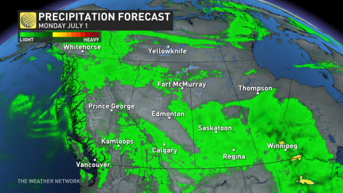
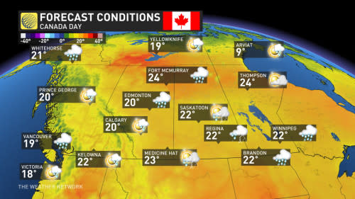
Things continue to go downhill into Canada Day as unsettled weather spreads all across the Prairies with heavy downpours and the risk of more organized thunderstorms.
The farther north you are, the warmer the temperatures will be –– by as much as 10°C across northern Alberta.
B.C.
The weekend doesn’t start all that unsettled, with shower chances higher across the northern and central coasts with temperatures near seasonal, unless you find yourself in northeastern B.C., where temperatures will be well above normal.
Saturday sees the southern Interior and the Okanagan Valley are squarely into the mid-20s.

The shower chances build around the South Coast on Sunday, but it’s hardly a washout. The thunderstorm risk will dance across northern B.C. on Saturday, before spreading across more terrain in the Interior on Sunday.
What about Canada Day? The onshore flow means there will continue to be shower chances at times with temperatures a few degrees below seasonal.
It could be worse, right?
Northern Canada
Some of the warmest temperatures in the entire country will be found across the 60th parallel this long weekend, with temperatures as warm as 12°C above normal.
Some of the only regions in the entire country to reach 30°C this long weekend will likely be across the Northwest Territories and northeastern B.C.
With files from Tyler Hamilton, a meteorologist at The Weather Network.


