
Severe storms with tornado risk take aim at the Prairies ahead of long weekend
As we close out June's final week, active weather on the Prairies is set to bubble up once again. A widespread thunderstorm threat spans the region on Thursday, with the risk for funnel clouds, and even tornadoes, to develop in some southern sections.
DON'T MISS: Canada Day weekend forecast: Changeable but comfortable, with no sign of heat
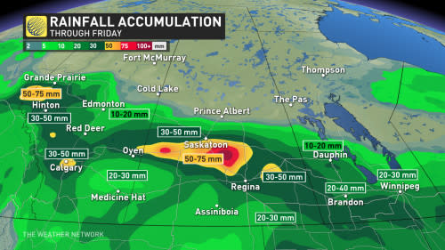
Heavy rainfall is also expected ahead of any long weekend festivities, with 40-60+ mm likely in the harder hit areas. Localized flooding could occur where the excessive rain falls.
Remember to stay weather-aware over the next couple of days, especially of you are planning on doing any travelling or are heading out for some summer camping.
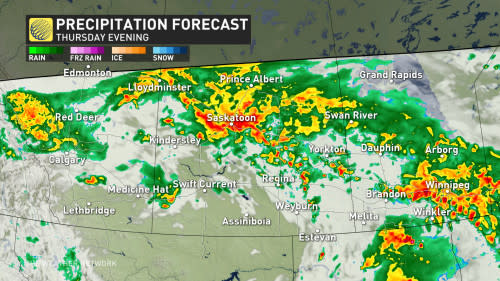
Severe weather risk moves in Thursday
A classic Alberta clipper will be the main driver of Thursday's rainfall and stormy weather. The system will send a warm front swinging into southern Saskatchewan, with storms developing in the late afternoon and evening hours, some which could become severe in nature.

Supercell storms could develop during this time and move eastward through the evening. There is the risk for some of these storms to also have rotation, triggering a tornado threat for the area.
Along with the possibility of one or two tornadoes in southern Saskatchewan, large hail and up to 90-100 km/h wind gusts are also hazards to look out for.

Heavy rainfall soaks the Prairies
The clipper will hit a standstill on Thursday and bring significant rainfall, as well as some embedded thunderstorms, to the rest of the Prairies.
In Alberta, there is the risk that funnel clouds could form. Sometimes, funnel clouds can develop further and become landspout tornadoes.
Folks travelling along the Yellowhead Highway should be prepared for the heavy rain and a localized flooding risk. Heavy rain can also reduce visibility and traction on roadways, so remember to always drive according to conditions.
SEE ALSO: A 'new star' may be just weeks from appearing in the northern sky
The rain will stick around through Friday as well, with between 40-60+ mm falling when all is said and done.
The system will move into Ontario by the start of the weekend, with Saturday looking to be a great day to enjoy the outdoors. Saturday may be the only day to enjoy, however, as a renewed storm threat makes its way back into the Prairie provinces on Sunday.
WATCH BELOW: Canada Day weather forecast
Stay with The Weather Network for more forecast information and details on your weather across the Prairies.

