
Canada’s spring forecast: Sluggish spring slowly comes to life
The heart of winter featured extended periods of early spring-like weather across most of Canada. However, since mid-February, spring has appeared to be content to sit on the sidelines while winter attempted to make up for lost time.
Now with spring officially underway, will we finally see more consistent warm weather?
MUST SEE: Tired of winter? Find out when it will stop snowing, Canada
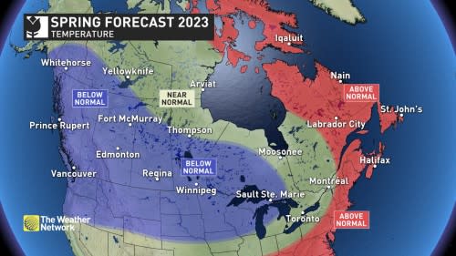
Across most of Canada we expect that spring will continue to be rather sluggish well into April. Of course, seasonal temperatures are steadily climbing, so the weeks ahead will not be as wintry as what we saw during the first few weeks of March.
Keep in mind that since spring is a season of transition, temperature roller coasters are normal with alternating periods of above-normal and below-normal temperatures. During late March and continuing through the first half of April, we expect that the shots of colder-than-normal temperatures will outweigh the periods of warmer weather across most of southern Canada.
However, as we get deeper into spring, we expect that the shots of colder weather will be focused across Western and Central Canada, and the periods of above-seasonal temperatures will be more dominant across Eastern Canada.
Here is a look at our national forecast map for the rest of March, April, and May.
Spring Pattern Drivers: Goodbye La Niña; Hello El Niño?
The primary driver of the spring weather pattern is the rapidly fading La Niña pattern in the Pacific Ocean. La Niña is associated with cooler-than-normal ocean water temperatures near the equator to the west of South America. This has a strong influence on the jet stream pattern across the northern hemisphere.
RELATED: La Niña is finally over. What does it mean for Canada’s forecast?
La Niña was the dominant pattern for the past three years, but this pattern has weakened dramatically during the past month, and it appears that we are headed into an El Niño pattern later this year (possibly as early as this summer) with warmer-than-normal ocean water temperatures across that same region. History tells us that a fading La Niña pattern is typically associated with a sluggish spring, especially across Western Canada.
In addition, we expect that the jet stream will continue to be in a blocking pattern over the Arctic through April and the polar vortex is expected to be more displaced than normal. This setup will continue to send shots of colder-than-normal temperatures into southern Canada.
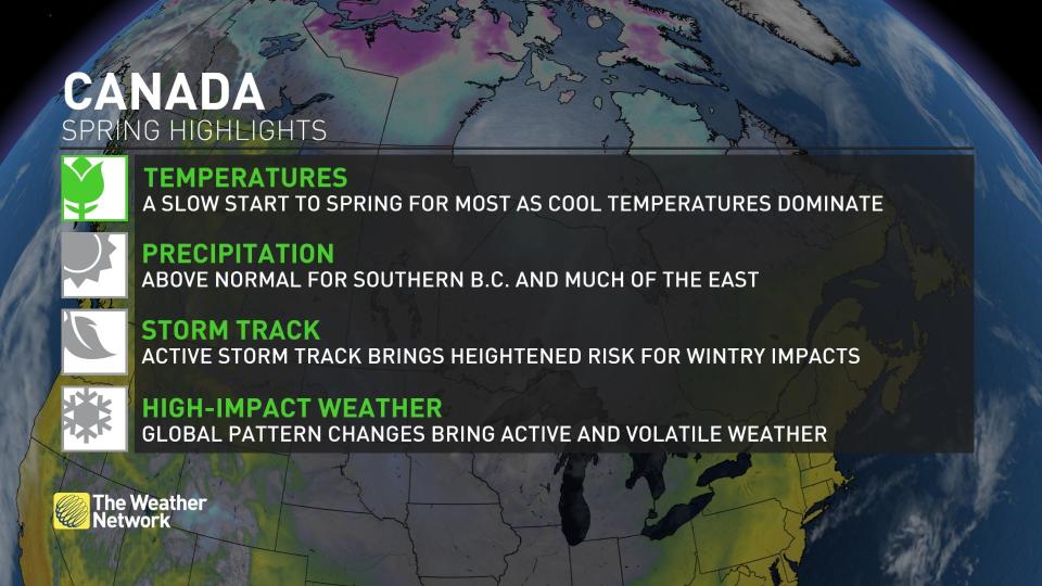
Spring is typically an active weather season as the atmosphere is in a state of change as we make the transition from winter to summer. Add to that the reversal in the primary pattern driver (especially one that has been with us for three years) and that is a recipe for active and stormy weather.
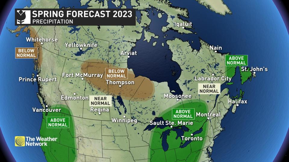
Therefore, we expect that most of Canada will see near-normal or above-normal precipitation for the season. The most active storm track is expected to be into the Great Lakes region, and also into parts of Atlantic Canada.
DON’T MISS: Snow robbery on B.C.'s hands this season. Where did it end up?
However, we are concerned that the active pattern will bypass parts of the Prairies with a risk for drier conditions to be even more widespread than what we currently have shown in our forecast. This is especially concerning since parts of the region are experiencing a multi-year drought and receiving adequate spring precipitation will be critical to a successful agricultural season.
For more details on when our sluggish spring will give way to more consistent warm weather, please check back on April 1st when we will release our national April forecast.

