
Canada's first 30-degree day felt in B.C. with more heat coming this weekend
It's official! Canada's first 30-degree day of the year has been reached, and the lucky winners are Lytton and Squamish, British Columbia.
Both communities saw temperatures soar well above seasonal values on Thursday, with an early taste of summer-like weather arriving just in time for the Mother's Day weekend.
DON'T MISS: Canada’s long weekend forecast may switch up your outdoor plans
The pattern change has forced a ridge to build over the province, bringing a long stretch of very dry and unseasonably warm weather across the region this week. Things will continue to heat up Saturday, with the likelihood of even more communities hitting that 30°C mark.
Remember it's May, however, a month that comes with varying extremes, so don't count on this blast of high heat to stick around for the unofficial kick-off to summer next weekend.
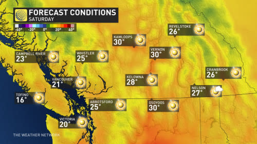
More 30-degree days likely this weekend
Temperatures began their steady climb on Thursday, with some areas seeing daytime highs about 10-12°C above normal for this time of year. Lytton hit 30.1°C on Thursday, while Squamish just barely made the threshold, sitting at exactly 30°C.
Highs soaring into the upper 20s will continue to be pretty widespread away from the coasts.
Temperatures will increase a degree or two more into Saturday, which will lock in the chance for several locations to hit 30°C, especially across the Interior.
Saturday will be the peak of the heat, however, as the ridge begins to slowly break down on Sunday and into Monday.
This pattern will certainly dry out many locations that saw a stretch of gloomy and wet weather at the end of April. Though welcomed by summer lovers and heat-seekers alike, it's not the best news to have such dry and hot weather this early in the fire season.
The only bright side to this pattern is that the warmest temperatures will likely miss northern B.C., which has been hardest hit by the ongoing drought conditions.
CANADA'S WILDFIRES: Visit The Weather Network's wildfire hub to keep up with the latest on the active start to wildfire season across Canada.
A cooler pattern is expected to take shape for next week, though much of southern B.C. will remain within a few degrees of seasonal.
Southern B.C. will also be mostly dry in the long range, with an active and wet pattern likely for the northern and central coast.
YOUR MAY OUTLOOK: Spring into summer or a stalling spring ahead, Canada?
Even though temperatures will remain around where they should for the middle of May, changeable conditions are possible across Western Canada for the long weekend. Don’t rule out the chance for showers if you’re heading outdoors, especially if you’re camping or hoping to catch some fireworks.
Stay tuned to The Weather Network for your latest forecast across British Columbia.

