
Hurricane Beryl morphs into record-breaking Cat 5 storm as it barrels through the Caribbean
Hurricane Beryl intensified Monday night into what forecasters are calling a “potentially catastrophic” Category 5 storm as it ripped off roofs, toppled trees and shut down power after barreling through eastern Caribbean islands — fueled by record warm waters. Beryl is now the earliest Category 5 storm on record to form in the Atlantic.
As of 11 p.m. Monday, Beryl’s winds had increased from 155 mph to 160 mph as the storm made its way to Jamaica and the Dominican Republic, the hurricane center said, adding that “some intensity fluctuations are possible in the near term” as it pushes further into the Caribbean.
The storm’s force is just the second time ever that an Atlantic hurricane has hit Category 5 status in July, when Hurricane Emily did the same on July 17, 2005, according the National Hurricane Center.
Beryl made landfall around 11 a.m. Monday on Grenada’s tiny Carriacou Island as the earliest Category 4 storm — a fast, hard punch to an island chain that rarely sees storms of that magnitude, especially this early in the season.
Amid the historic early-season whopper of a storm, power was out throughout Carriacou and nearby islands, many of which were under hurricane and tropical storm warnings. It roared through with 150 mph sustained winds, the high end of Category 4, and brought rain and 6 to 9 feet of storm surge.
“It’s bad and we have not seen the worst yet. The next few hours are going to be worse,” St. Vincent and the Grenadines Prime Minister Ralph Gonsalves told the Miami Herald in an interview around noon Monday. “As it reaches close to us, we will be getting the full effect of the hurricane.”
Beryl’s eye also was clear of the island chain and bound for a potentially destructive brush with Jamaica as of late Monday. It was on a track with sea surface waters so hot they’re running at average September temperatures, as well as a pocket of friendly, storm-aiding winds.
The hurricane center added that the storm had another 24 hours or so of runway ahead, and it could potentially strengthen even further, breaking more records.
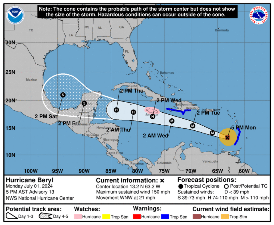
However, there was some small encouraging news for Jamaica. Forecasters noted that around Tuesday afternoon atmospheric conditions in the form of stronger wind shear could weaken Beryl down to Category 2 or 3 by the time its eye passes south of the heavily populated island on Wednesday.
Several shifts over the day on Monday nudged the potential track of Beryl’s eye close to Jamaica, which issued a hurricane watch for the island, and the southern coast of Haiti and the Dominican Republic, which upgraded their tropical storm watches to warnings Monday evening.
According to an 8 p.m. update, Beryl’s eyewall was about 575 miles east-southeast of Isla Beata, Dominican Republic, and 910 miles east-southeast of Kingston, Jamaica, according to the National Hurricane Center. The storm was heading west-northwest at 21 mph with sustained winds near 155 mph, making it a strong Category 4.
The government of Jamaica has issued a hurricane warning for the island, meaning tropical storm-force winds are expected within the next 36 hours, the National Hurricane Center stated.
A tropical storm warning is in effect for the south coast of the Dominican Republic, from Punta Palenque, northwest to the border with Haiti, federal forecasters said. The warning is in effect for Haiti from the border with the Dominican Republic to Anse d’Hainault.
READ MORE: ‘It’s bad and we have not seen the worst yet.’ Initial damage reports from Beryl
Early Monday, hurricane hunter planes swooped over the roiling storm and found it in the final stages of an eyewall replacement cycle, where a bigger, stronger eye emerges and dwarfs the previous one. Storms typically weaken a bit during the replacement cycle but some emerge stronger on the other side, as Beryl did.
Overnight, during the replacement cycle, the slightly weakened Beryl grew its wind field substantially, increasing its reach for storm surge and wind effects in the eastern Caribbean. Around 8 p.m., hurricane-force winds extended 40 miles from the center, and tropical storm-force winds extended up to 125 miles out.
Over the weekend, Beryl surpassed expectations and rapidly intensified into the first major hurricane of the season in the abnormally hot Atlantic. Beryl became the earliest Category 4 storm to form in the Atlantic, beating out a record from Hurricane Dennis set on July 8, 2005, a notably intense year for storms.
READ MORE: What happens when hurricanes rapidly intensify? And how does climate change affect it?
Battering in the Caribbean
It was too early to assess Beryl’s toll but the preliminary reports suggested widespread flooding and damage. Prime ministers of Grenada, St. Vincent and the Grenadines and Antigua told the Miami Herald early Monday evening they had no confirmed deaths due to the storm yet.
“Initial reports have indicated significant damage and destruction to infrastructure and private property in some territories,” said Guyana President Mohamed Irfaan Ali, who currently serves as chairman of the 15-member Caribbean Community regional grouping known as CARICOM.
As Beryl battered the small island of Carriacou, off the coast of Grenada, in St. Vincent and the Grenadines residents were also feeling the Beryl’s strong Category 4 winds, which brought the surf inland. Prime Minister Gonsalves said the eye’s passage over the southern Grenadines “has caused severe damage in Grenada and we are getting the other bands of the wind.”
“We’re getting lots of rain, massive wave action. A lot of houses have lost their roofs and the brunt hasn’t hit us yet,” Gonsalves said. “In Carriacou, they’ve lost a lot of roofs, and in Union Islands.”
Gonsalves said he has received reports of at least one death on Union Island, and there is damage to the fence at the international airport, which he said will be closed Tuesday to commercial flights, but will be receiving planes bringing in supplies.
“This is a difficult time..we are a resilient people,” Gonsalves said in a press conference Monday night. “Today has been a rough day. It has been a day of much devastation.”
“I want us to recover together,” he added
Wind gusts of 175 mph were registered for Carriacou and Petite Martinique in the southern Grenadines.
Illustration of how much Beryl grew after its eyewall replacement cycle. Double the size (based on its radius of maximum winds) vs last night https://t.co/EWFj5Yru2Y
— Michael Lowry (@MichaelRLowry) July 1, 2024
In preparations for the hurricane’s passage, several islands in the storm’s path shut down early on Sunday, which included ceasing all air travel. Ahead of the storm, Gonsalves declared a disaster area for the whole country, while Grenada’s government declared a state of emergency.
“It’s bad no question about it, a lot of homes are down, electricity is off. It’s bad, it’s bad,” Gonsalves said.
On Monday, at least five arrivals and six departures were canceled from Miami International Airport due to the storm. Any flight to or from Barbados, Trinidad, St. Vincent, Grenada and St. Lucia was also canceled.
In Grenada, which bore the brunt of the damage, officials were beginning to take stock of what appeared to be extensive damages.
“We have reports of extensive storm surge, we have reports of extensive loss of roofs and damage. There is no electricity and communication is also difficult,” Grenada Prime Minister Dickon Mitchell said in a news briefing after the eye passed over the island of Carriacou around 11:10 a.m. Monday.
Mitchell said he has already given instructions for residents of Carriacou and Petite Martinique to be given temporary housing. Additionally, they are working on identifying stocks of tarps and other supplies on the two islands to assist those affected by the hurricane. Mitchell said Union Island, which is dependent on St. Vincent and the Grenadines, has also suffered damages.
On the island of Grenada, there were reports of a central police station on Carenage and a hospital also receiving damage. Mitchell said he plans to visit the islands as soon as it is safe to do so, but he has been warned “there was devastation all around.”
In anticipation of Beryl’s arrival, Jamaican authorities announced Monday that more than 800 shelters across the country stand ready while earlier warning systems have been put up in some areas and relief supplies have already been secured.
“I want to give the country the assurance that the Office of Disaster Preparedness and Emergency Management is in a position to respond, and to respond positively to any outcome that faces us over the next couple of hours,” said Desmond McKenzie, the minister in charge of local government and community development.
Prime Minister Andrew Holness said the unusual storm system with its historic strength and presence this early in the hurricane season “is a signal of the climate change issues that we are always very cognizant of.”
What’s next?
Once it clears the Windward Islands, Beryl’s future is a little less clear. The latest hurricane center forecast track keeps the storm on a straight shot to the Yucatan, where it could make landfall near Belize as a Category 1 hurricane or tropical storm on Friday morning.
On the way, it could pass dangerously close to Jamaica on Wednesday, enough to lash the island with high winds and storm surge.
The hurricane center said it was unclear what Beryl’s next move could be once it crossed the Yucatan. It could slow down to a crawl and dissipate over land, or re-emerge in the hot Gulf of Mexico and potentially find a new target for landfall.
“The official prediction still shows Beryl emerging into the southwestern Gulf of Mexico as a tropical storm at day 5, but the track uncertainty is greater with more ensemble spread during this period,” forecasters wrote in the 5 p.m. discussion.
On the other side of the Yucatan, short-lived Tropical Storm Chris fizzled out early Monday, dumping some rain over Mexico and crossing another name off the list.
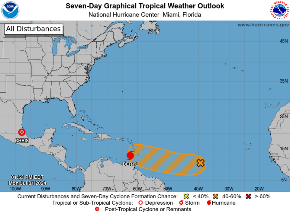
The next contender could be right behind Beryl, a disturbance the hurricane center has tagged with a 50% chance of strengthening into a tropical depression within the next seven days, and a 20% chance of forming in the next two, as of the 2 p.m. update.
Those figures are a solid downgrade from Sunday evening’s figures, a sign that the cooler water left in Beryl’s wake and increased wind shear nearby could slow down the development of anything behind it.
“Environmental conditions appear marginally conducive for additional development of this system, and a tropical depression could form by the middle part of this week while it moves generally westward at 15 to 20 mph across the central and western tropical Atlantic,” forecasters wrote.
The next name on the list is Debby.
Miami Herald staff writers Vinod Sreeharsha and David Goodhue contributed to this report.

