
Caution urged for travel in parts of Ontario as ice will coat roads
Winter has come out swinging in Ontario this week, bringing a round of messy weather that will make even walking outdoors a tricky feat in parts of the province. Through Thursday morning, some areas can expect to see 5-15 mm of ice accretion from prolonged freezing rain while others see heavy rain, hefty snow and even ice pellets thrown in.
Surfaces such as highways, roads, walkways and parking lots may become icy and slippery. Take extra care when walking or driving in affected areas. Slow down driving in slippery conditions.
SEE ALSO: Will winter stage a comeback this month? Find out in our official January Outlook
A Bermuda high will act as the the main gear in a conveyor belt of moisture being ushered north from the Gulf of Mexico this week. At the same time, high pressure from Canada's North will be the gatekeeper to much cooler air that will get funnelled south.
The two air masses will meet over Ontario, leading to a fury of heavy rain and a swath of snow, with a prolonged freezing rain event in between.

As the moisture meets cooler air towards the Ottawa Valley and the Ontario-Quebec provincial border, precipitation will transition to snow, freezing rain and ice into Thursday.
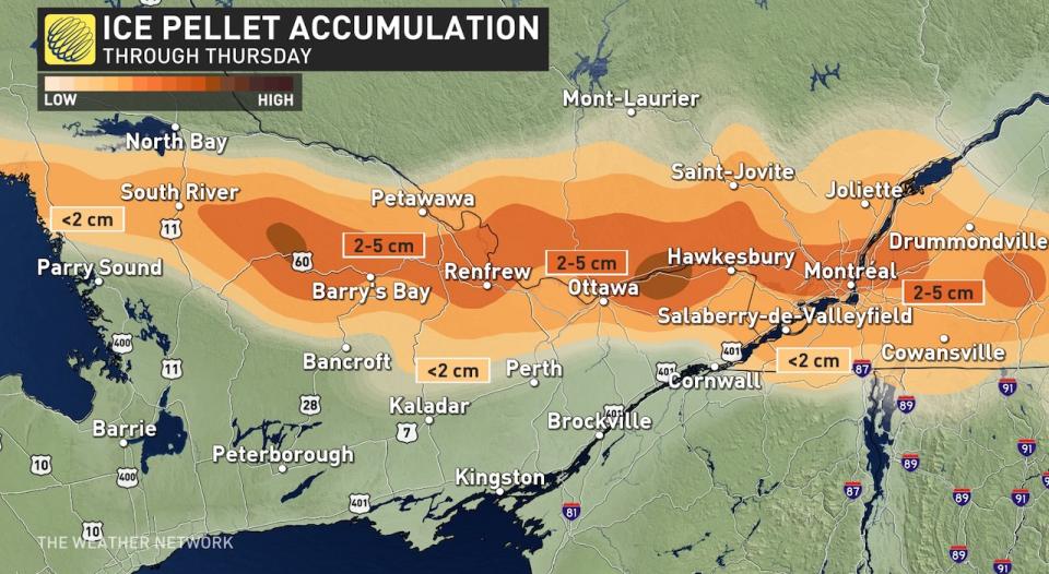
A swath of freezing rain will develop across parts of cottage country and eastern Ontario through Wednesday evening and continue overnight.
Ice accumulation could be between 5-15 mm in regions that see the most prolonged period.
MUST SEE: Shop our best of 2022 list and be ready for any weather condition
The ice accretion from freezing rain could cause travel issues, and possible damage to trees and power lines in the hardest-hit areas.
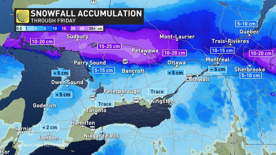
A heavier swath of snow is forecast on the northern extent of this system, potentially spreading 10 to locally 25 cm of snow to northern cottage country, North Bay and north of the Ottawa area, plus south of the St. Lawrence River in Quebec.
Ottawa remains a tricky forecast, however, as it is riding the line between seeing significant snowfall or more of an ice pellet event, depending on how far north the warm air nudges.

Widespread flurries on the backend of the system Thursday can be expected across southern and eastern Ontario as the upper low associated with the system swings through.
Temperatures will start to fall back toward seasonal behind this system, with daytime highs around the freezing mark expected for much of the region by next weekend.
Check back for the latest on conditions across Ontario.

