
How cold will Miami get? Will Florida see frost? Will iguanas fall? What forecast says
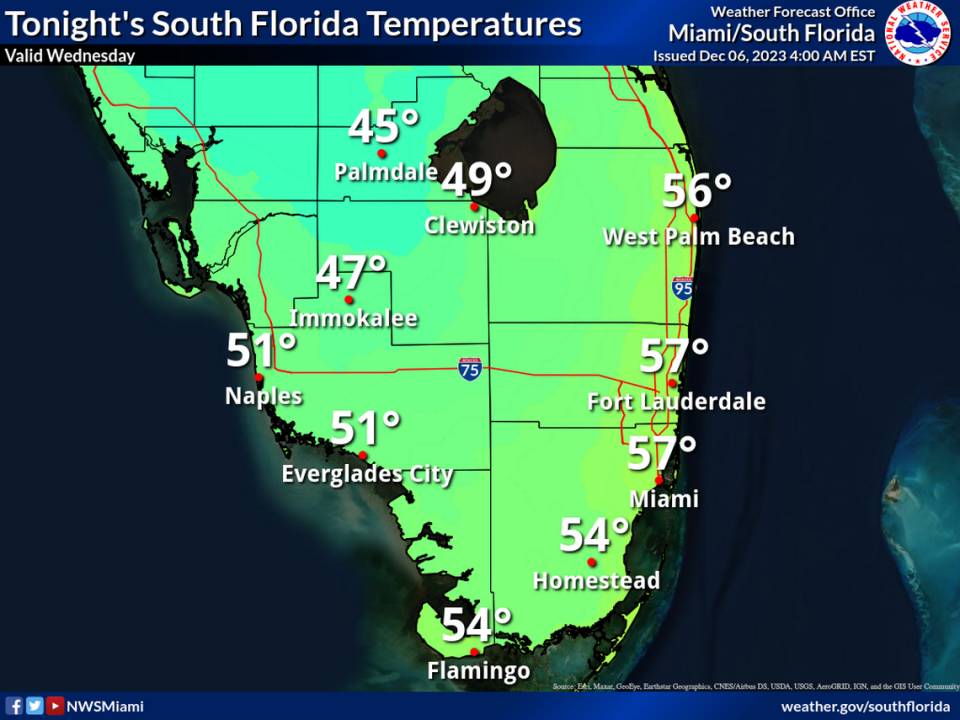
We got a cool preview Wednesday morning, with temperatures dipping into the upper-50s and low-60s in parts of South Florida.
Now get ready for the cold.
A front pushing through Florida will make it seem downright frío across Miami, Fort Lauderdale, Palm Beach and the Florida Keys, perhaps propelling our bundled-up selves to the cafeteria to pick up some churros and hot chocolate.
How cold will it get? And will Florida get frost?
Here’s the latest update from the National Weather Service:
How cold will it get in South Florida?
If you are an early riser, expect to wake up Thursday morning to temperatures in the mid-50s across South Florida.
“It is feeling a little more like December and winter in South Florida,” CBS News Miami meteorologist Lissette Gonzalez said Wednesday. “It will be turtleneck weather.”
Expect a mainly dry Thursday, with highs in the mid-70s and 10 mph winds.
Will it be as chilly in the Florida Keys?
Temperatures in the 50s are not forecast to extend to the Florida Keys.
Look ahead to a breezy early Thursday morning across the Keys, with lows in the low-60s in Key Largo and upper-60s in Key West.
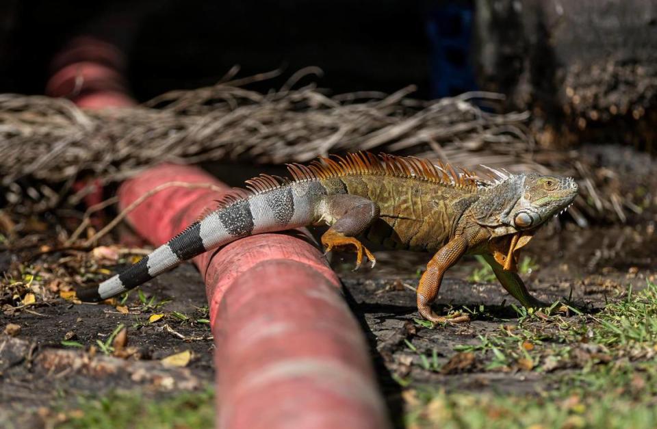
Will iguanas fall from trees?
The cold-blooded invasive species slow down and become immobile when temperatures dip into the 40s. When that happens, they may fall from trees.
Because the temperatures across most of South Florida are forecast to drop into the mid-50s, don’t expect iguanas to drop from the trees.
What about the weekend weather forecast?
Look forward to a gradual warm-up over the weekend across South Florida as Art Week continues.
Early Friday morning won’t be as cold as Thursday, with lows around the mid-60s. Highs later that day are expected to reach the upper 70s.
Saturday is forecast to be partly cloudy with highs around 80 and lows in the lower-70s.
A 50% chance of rain Sunday could end the region’s dry spell. Expect highs in the lower-80s and lows in the upper-60s.
Will parts of Florida get frost?
If you are traveling north, look forward to potential frost late Wednesday night and early Thursday morning in the Tallahassee region, with lows in the 30s, and Jacksonville and Pensacola areas, with lows in the low-40s.
Forecasters recommend covering outside plants and bringing pets inside in these areas.
Temperatures on the decline
A dry cold front will pass through the area tonight into Wed. Inland frost will be possible Thu morning as temps drop into the mid to upper 30s.
Don’t forget to cover your plants & bring your pets indoors Wed night ! #gawx #flwx pic.twitter.com/am5j0KXydg— NWS Jacksonville (@NWSJacksonville) December 5, 2023
A cold front pushed through early this AM & will set the stage for a cool Wednesday with highs climbing into the middle to upper 50s to near 60 under an increasingly sunny sky. Frost is possible tonight for much of the area away from the immediate coast. #alwx #flwx #gawx pic.twitter.com/5aQVg0Jrjw
— NWS Tallahassee (@NWSTallahassee) December 6, 2023

