
Stormy end to March in Quebec as heavy rain, snow pelt province
March's last "roar" will see heavy rain and snow push across Quebec, as another far-reaching and moisture filled system is set to pack quite the punch.
As is typical with Colorado lows, they drag abundant moisture from the Gulf of Mexico, and funnel it right into the region. With some cooler air to work with ahead of and behind this system, there will be transitions from snow to rain, and then back to snow again through Saturday.
RELATED: A cavalcade of Colorado lows can send Canada’s forecast into upheaval
The precipitation will work its way into the province well before the actual low passes over southern Quebec on Saturday afternoon.
The snow will begin filling in across western and southern Quebec ahead of the warm front on Friday. Accumulations will range from just a couple of centimetres south of the St. Lawrence, to between 5 and 15 cm of snow for western Quebec, near the upper Ottawa Valley.
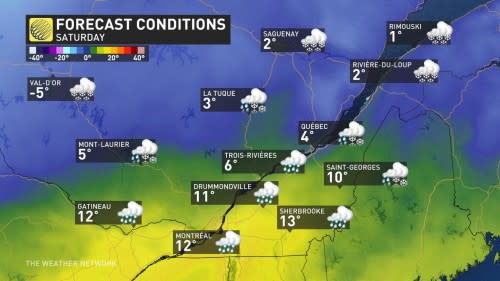
By the overnight hours on Friday, the snow begins to transition to rain. The transition zone, and rain/snow boundary, will push eastward through Saturday morning, with rain spreading from the upper Ottawa Valley, across to Quebec City and southward.
Rainfall continues through Saturday afternoon, while the snow gradually tapers across western Quebec. Through Saturday evening, the rain will briefly change back to snow as cooler temperatures wrap in, before ending by Saturday night.

Precipitation will remain as snow to the north, and with heavy accumulations at that, so travel conditions could be difficult at times.
MUST SEE: March madness: Canada’s month-long, wild ride of weather
By the time all is said and done, parts of western Quebec could see between 20-30 cm of snow. Just north of the St. Lawrence 5-15 cm is expected, with Montreal, Sherbrooke and the Eastern Townships likely to see less than 5 cm of snow.
Most areas can expect a widespread 5-15 mm of rain, but with pockets of 15-25 mm around Montreal and Gatineau.
An active pattern is expected to continue through the first week of April, as a couple significant systems track across the region
Be sure to check back for the latest weather updates across Quebec.

