
Colorful new hurricane cone of uncertainty is coming to forecast maps. Take a look
Cone of concern. Cone of dread. Even cone of death. The National Hurricane Center’s familiar forecast map goes by a lot of unofficial nicknames, all of which reflect this undeniable fact: You feel worried if you’re in it and better if you’re not.
That misreading of the forecast cone has made it the subject of some criticism over the years — that it fails to reflect the risks posed to coastal communities that may be out of the cone one day but in it the next, or close enough to the eye of a storm to still see serious damage.
This year, the NHC is rolling out an experimental version intended to address those issues by adding new layers of threats and a lot more colors. The NHC believes the new map better threads the needle between informing the public and confusing it.
“Recommendations from social science research suggest that the addition of inland watches and warnings to the cone graphic will help communicate wind risk during tropical cyclone events while not overcomplicating the current version of the graphic with too many data layers,” NHC wrote in a release announcing the change.
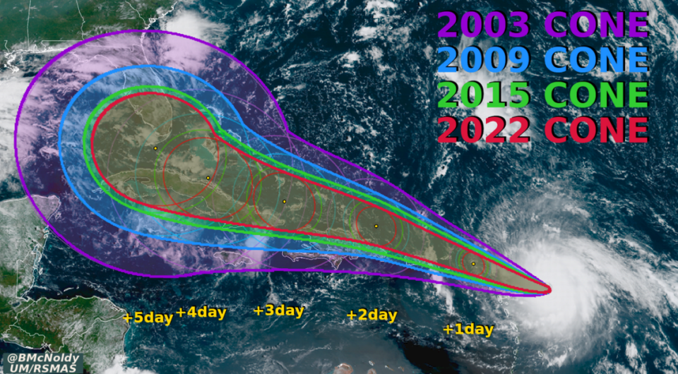
The cone, introduced 22 years ago, has been misinterpreted by the general public practically since day one. It’s meant to show the hurricane center’s best guess for where the eye of the storm will travel, with a cone around it that follows a formula based on the average errors the hurricane center makes when tracking a storm. As the science improves, the cone shrinks.
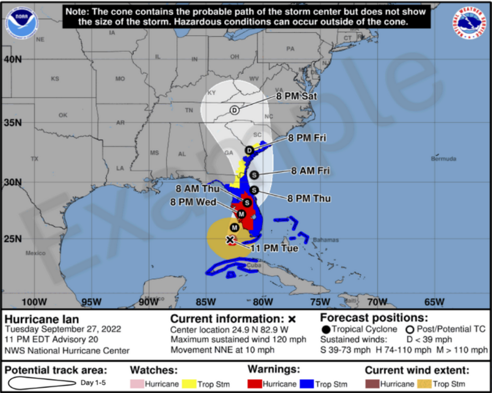
It’s a handy tool for showing where a storm may go, but even a tiny track shift can translate to a big change for a hurricane that parallels Florida’s long coastline. Infamously, the relatively minor shifts in the hurricane center’s predictions for Hurricane Ian’s path in 2022 led to entire counties in Florida exiting the cone’s shaded area — and, in some cases, delaying or avoiding calls for evacuation in response.
But as those Floridians learned in Ian, the impacts of a hurricane occur far outside the shaded lines of NHC’s cone.
READ MORE: The ‘cone of uncertainty’ is getting smaller — but it still matters if you’re outside it
That’s why the hurricane center is debuting a new pilot version of its cone this hurricane season.
The current cone — which isn’t going anywhere anytime soon — shows the projected path of a storm and colorful outlines along the coast of states or islands, representing spots where storm watches and warnings are in place.
Starting August 15, the hurricane center will also publish an experimental second version of the cone, where the inland spots under watches and warnings will also be colored in red and blue. Tropical storm warnings will be represented in yellow. Those areas used to be just highlighted along the coast. The new version also will show the wind field of the storm, with tropical storm force depicted in a gold tone and hurricane force in brown. That will show how far out the damaging winds stretch — an addition that should make residents outside the cone more aware of the potential impacts.
Another key change happening this year is that the hurricane center will start producing even more text advisories in Spanish.
Starting this year, all public advisories, tropical cyclone discussions, tropical cyclone updates and key messages in the Atlantic basin will also be available in Spanish. The text products will be translated using artificial intelligence, a technique the hurricane center experimented with last year.

