
Damaging winds, outage risk sweep into the Maritimes on Monday
Sunday night is the last opportunity for folks across the Maritimes to prepare for a spell of damaging winds set to sweep into the region on Monday.
Winds will pick up through the morning and peak into the afternoon and evening hours. Expect disruptive power outages, tree damage, and the potential for objects blowing around during the high winds.
Keep your electronic devices charged in case the power goes out on Monday.
Ensure any outdoor furniture or holiday decorations are tied down, secured, or brought inside before the high winds arrive. These items are notorious for blowing around and causing damage or injuries in winds half as strong as predicted on Monday.
Going somewhere? Check out the current highway conditions before heading out!
While we’ll see the rain before the wind, make no mistake: this will be a wind event rather than a rain event.
A growing low-pressure system developing over New England will roll into eastern Quebec and New Brunswick overnight Sunday into the day Monday.

Heavy rain will push into New Brunswick as the system moves closer to the region on Sunday night, with rainfall rates peaking on Monday morning.
Central and northern New Brunswick could see up to 80 mm of rain, while eastern sections may receive 30-50 mm in the gauges. General totals of 10-30 mm are expected across the rest of the Maritimes.
Winds largely arrive after the rain during the day Monday, which is when we’ll see the issues stack up across the region.
Widespread wind gusts of 100+ km/h are expected throughout the Maritime provinces, with the stiffest gusts likely along south- and east-facing coastlines. Winds will peak for these areas through the afternoon and evening hours before subsiding on Monday night.
WATCH: A warm up and damaging winds on the way for Halifax
DON’T MISS: Staying safe during a power outage
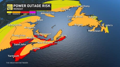
The greatest risk for wind damage and power outages will exist along the coast where 110 km/h gusts are possible, including the Bay of Fundy shores and along Nova Scotia’s southern coast. This covers the communities of Saint John, Yarmouth, and the Halifax area.
Tree damage and power outages are likely given the coverage and intensity of the winds expected across the Maritimes.

Ensure any outdoor holiday decorations are well-secured or brought inside before the winds begin. Inflatable characters and lightweight decor can take flight in winds half this strong, potentially causing damage, injuries, or even car accidents.
Remain mindful of large trees or tree limbs looming over homes, roads, and driveways, and take care to avoid those areas during the highest winds. Most wind-related injuries are caused by trees falling into buildings or vehicles.
We’ll see the winds calm down Monday overnight, though conditions will remain blustery across Newfoundland into Tuesday.

SEE ALSO: Mammoth, continent-spanning storms surround Canada
The powerful southerly winds ripping into the area will drag plenty of mild air in from the south. We’ll see daytime highs across most of the Maritimes soar into the mid-teens during the day Monday. But the warmup won’t last long.
Temperatures will cool abruptly behind the cold front, bringing along a wind chill that’ll make it feel even cooler. Conditions will remain around or just below seasonal for the remainder of the week.
Stay with The Weather Network for the latest on conditions across Atlantic Canada.

