
El Niño is over—but La Niña may arrive during peak hurricane season
El Niño is gone and La Niña might arrive in time for the peak of hurricane season.
That’s the word this month from forecasters monitoring sea surface temperatures across a critical part of the Pacific Ocean.
Cooling waters off the coast of South America may have far-reaching effects in the atmosphere that could influence Canada’s weather through hurricane season and beyond.
Keep up with the latest El Niño and La Niña news at The Weather Network’s hub page.
The latest update from the U.S. Climate Prediction Center (CPC) says we’re officially in “ENSO-neutral” conditions this month, meaning that the El Niño we saw through the winter months finally came to an end in May.
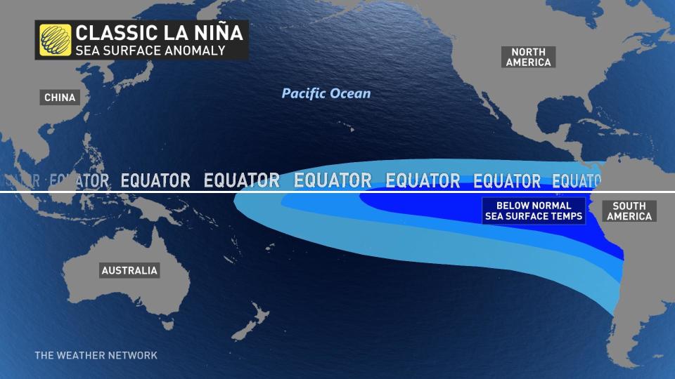
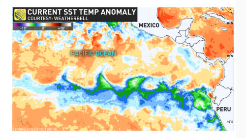
As water temperatures near the equator off the western coast of South America continue to cool in a hurry, forecasters expect the opposite pattern—a La Niña—to develop over the coming months.
DON'T MISS: Sunshine and warm temperatures—is this Canada's ideal summer forecast?
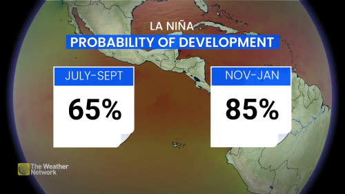
The official forecast released on June , calls for a 65 percent chance of La Niña developing by September. There's an 85 percent chance that La Niña conditions will be in place by the middle of winter.
An onset by September would arrive just in time for the peak of hurricane season.
MUST SEE: The Atlantic Ocean’s high fever could fuel an ugly hurricane season
The oscillating patterns of El Niño and La Niña have a profound effect on global weather patterns, especially during the winter months. But these patterns can greatly influence Atlantic hurricane seasons by altering the amount of wind shear blowing across the region.
While an El Niño tends to suppress Atlantic hurricane activity by increasing wind shear, La Niña events have the opposite effect by subduing destructive wind shear to an extent that it can lead to an active hurricane season.
Very warm waters across the Atlantic Ocean overpowered El Niño’s subduing influence, driving above-average hurricane activity despite the odds.
RELATED: How hot water fuels the world’s most powerful hurricanes
Given the expected development of La Niña and even warmer Atlantic ocean temperatures this year, hurricane experts almost unanimously expect a very active season in the months ahead.
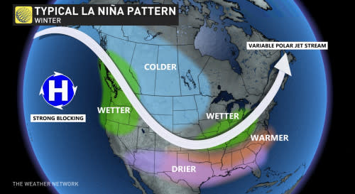
Looking beyond hurricane season, a budding La Niña could affect Canada’s winter weather as well. Historically, winters dominated by La Niña conditions have seen below-seasonal temperatures and above-seasonal precipitation across much of Western Canada, with changeable conditions back east.

