
Tricky Thursday travel as snowy blast hits parts of the Prairies
After spending nearly a week basking in well above seasonal and double-digit-high temperatures, parts of the southern Prairies are now dealing with a wintry hiccup.
MUST SEE: Edmonton's average daytime high hits 0°C, a trend that could span 100+ days
Southern Alberta is the meeting ground for Pacific moisture coming in from Washington, as well a descending cold front from the Arctic. A narrow boundary of snow will straddle the international border, spreading across parts of the Prairies on Thursday.
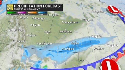
In all, between 3-15 cm of snow is expected in the areas that see the snow, with snowfall warnings covering parts of Saskatchewan and Manitoba early Thursday, including the city of Brandon.
"Rapid accumulation of snow will make travel difficult. Visibility may be suddenly reduced at times in heavy snow," says Environment and Climate Change Canada (ECCC) in the warning. "Adapt your driving to changing road conditions."
The odd structure of this storm, however, will confine the stronger wind gusts to the Dakotas, so blowing snow should not be a major concern. Gusts between 20-40 km/h will pick up on Thursday morning.

Unlike Alberta clippers, this storm will not open the door for a surge of Arctic air behind it, either.
RELATED: Hopes for Edmonton's ski season are going downhill with no snow or cold
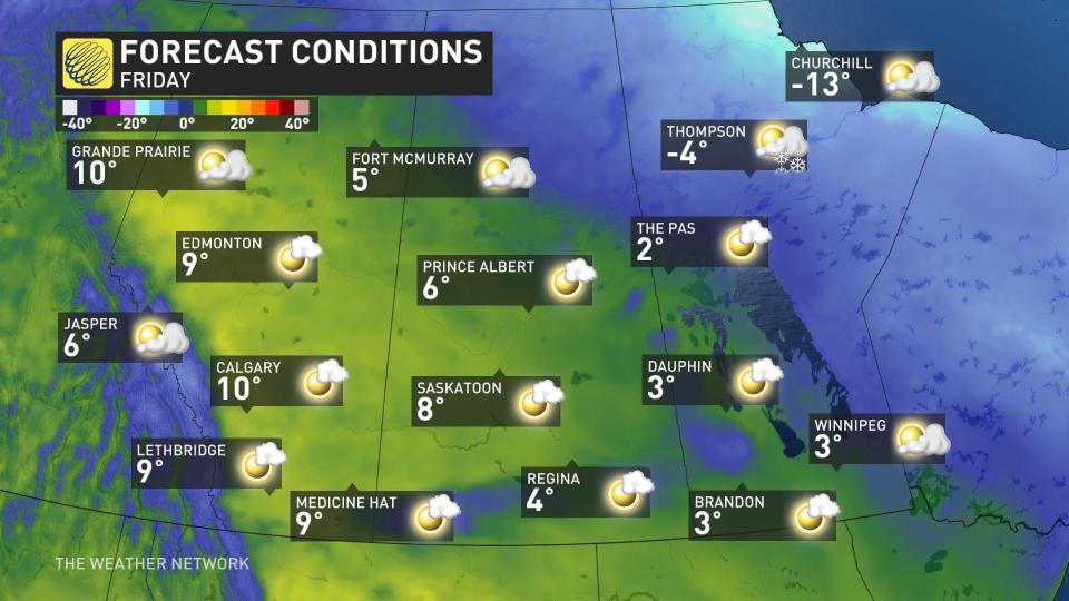
In fact, a quick return to warm, downsloping Pacific air will be welcomed by much of the western Prairies by Friday, even stretching to the most northern limits of the region. The week will end with temperatures about 5°C to 15°C above normal for much of the Prairies.
Much colder weather will spread across the region next week, but it now appears that the coldest weather will be focused farther to the east, resulting in a lot of uncertainty regarding the duration and magnitude of the Arctic air for southern Alberta. Near seasonal or colder-than-seasonal temperatures are expected to dominate across most of the region from the middle of next week through the beginning of the following week.
No major storms are expected through the middle of next week.

