
First Map of Jupiter's Giant Moon Ganymede Unveiled (Photos, Video)

The largest moon in the solar system has finally received its cartographic due.
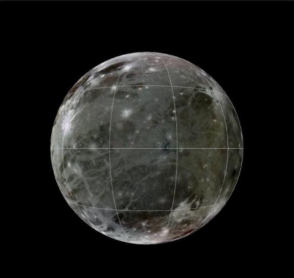
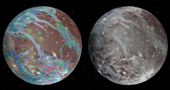
Scientists have created the first global geological map of Jupiter's huge, ice-covered moon Ganymede, more than 400 years after its discovery by Galileo Galilei. The map, created using observations by NASA's twin Voyager probes and Galileo orbiter, highlights the varied terrain of Ganymede, which is bigger than the planet Mercury.
"This map illustrates the incredible variety of geological features on Ganymede and helps to make order from the apparent chaos of its complex surface," Robert Pappalardo, of NASA's Jet Propulsion Laboratory in Pasadena, Calif., said in a statement. "This map is helping planetary scientists to decipher the evolution of this icy world and will aid in upcoming spacecraft observations." [Watch the video animation of the 1st full map of Jupiter's giant moon Ganymede]
The new map, which was published by the U.S. Geological Survey (USGS), could also help scientists plan out the search for alien life, researchers said.
"After Mars, the interiors of icy satellites of Jupiter are considered the best candidates for habitable environments for life in our solar system," USGS Astrogeology Science Center director Laszlo Kestay said in a statement. "This geologic map will be the basis for many decisions by NASA and partners regarding future U.S. missions under consideration to explore these worlds."
Observations of Jupiter's largest moon made since its discovery in 1610 have revealed many features and facts about Ganymede over the centuries. They show that the 3,273-mile-wide (5,268 kilometers) moon possesses dark, heavily cratered terrain as well as lighter, younger regions marked by many grooves and ridges.
The moon's features have been shaped during three major geologic periods — one dominated by impact cratering, then another marked by lots of tectonic activity and finally a third in which this activity tapered off, scientists said.
"The highly detailed, colorful map confirmed a number of outstanding scientific hypotheses regarding Ganymede's geologic history, and also disproved others," said Baerbel Lucchitta, scientist emeritus at the USGS in Flagstaff, Ariz. "For example, the more detailed Galileo images showed that cryovolcanism, or the creation of volcanoes that erupt water and ice, is very rare on Ganymede."
Voyager 1 and 2 flew by Ganymede in 1979 during their unprecedented solar system "grand tour," then kept on going all the way toward interstellar space (which Voyager 1 entered in August 2012). The Galileo probe studied Ganymede and many other members of the Jovian system while orbiting Jupiter from 1995 through 2003.
You can download a high-resolution copy of the new Ganymede geologic map for free at the USGS website here: http://pubs.usgs.gov/sim/3237/
Follow Mike Wall on Twitter @michaeldwall and Google+. Follow us @Spacedotcom, Facebook or Google+. Originally published on Space.com.
Copyright 2014 SPACE.com, a TechMediaNetwork company. All rights reserved. This material may not be published, broadcast, rewritten or redistributed.
