
Five tropical systems are rumbling across the Atlantic. Will they affect SC?
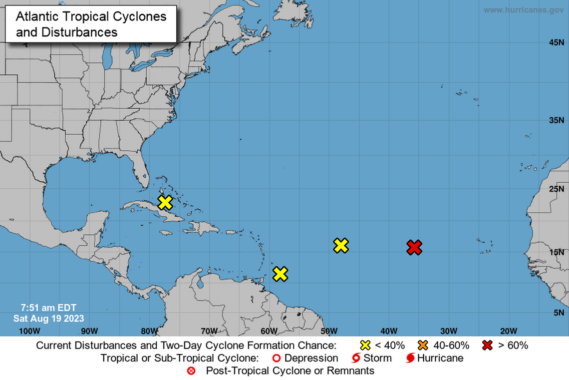
The National Hurricane Center is tracking five tropical disturbances from the west African coast to Cuba that may develop into storm systems within the next several days.
None of them is expected to bring bad conditions into coastal parts of South Carolina, with the National Weather Service forecasting calm skies and temperatures into the 90s for much of the week.
The Atlantic hurricane season runs June 1 through Nov. 30. Federal meteorologists are predicting between 12 and 17 named storms with winds of 39 mph or higher, with 70% confidence that at least one could turn into a major hurricane by Dec. 1.
It may be quiet over the Carolinas in the near future, but the peak of hurricane season is approaching. Take action TODAY to be better prepared for when the worst can happen. #HurricanePrep #HurricaneStrong visit https://t.co/rDRQzeDlKdhttps://t.co/5FXZ3FtWyg pic.twitter.com/ryHWmZPRXI
— NWS Wilmington, NC (@NWSWilmingtonNC) August 19, 2023
NOAA has revised its hurricane forecast
Last week, NOAA updated its prediction for the 2023 season and is calling for an “above normal” level of storm activity because of record-high temperatures in ocean surface waters. Those temperatures are likely to offset the hurricane-suppressing effects of an ongoing El Niño.
Including storms that have already occurred this season, NOAA now forecasts: 14-21 named storms (with winds of 39 mph or greater), of which six to 11 could become hurricanes (with winds of 74 mph or greater). Of those, two to five could become major hurricanes (with winds of 111 mph or greater). NOAA forecasters say they have 70% confidence in those ranges.
335pm EDT Sat 19 August: A Special Tropical Weather Outlook has been issued for Invest #99L, which has become better organized & now has a high chance ( 70%) of becoming a short-lived tropical depression this afternoon or evening.
Special Outlook: https://t.co/NERCKLZFZm pic.twitter.com/LPcQALnHAB— National Hurricane Center (@NHC_Atlantic) August 19, 2023
Here are the four systems
A low-pressure system in the eastern tropical Atlantic, several hundred miles west of the Cabo Verde Islands. NOAA says the system is likely to develop into a tropical depression over the weekend as the system moves west-northwest, but upper-level winds over the system early next week are likely to prevent it from becoming a tropical storm.
An elongated low-pressure system in the central tropical Atlantic, between the Cabo Verde Islands and the Lesser Antilles. NOAA says this one is producing showers and thunderstorms, but upper-level winds are likely to prevent it from developing further.
Several hundred miles east-southeast of the Lesser Antilles is a trough of low pressure NOAA says could develop into a tropical depression as it moves west-northwest toward the Caribbean over the weekend and into next week.
In the Greater Antilles, a disturbance near the northwestern and central Bahamas is expected to move into the Gulf of Mexico by early next week, where a broad area of low pressure is expected to form. It could slowly form a tropical depression as it moves westward and approaches the western Gulf Coast by the mid-week, NOAA says.

