
Fog, rime ice dominate stagnant Prairie weather pattern

Saskatchewan is caught in a rinse-and-repeat weather pattern.
Day after day there has been cloud cover, fog and rime ice on trees.
For some, it's a beautiful winter paradise. For other, the days are gloomy and drab.
Here's what's causing this pattern.
The upper atmosphere is controlled by the jet stream, a narrow band of fast-moving air that is wrapped around Earth. It generally separates warm air to the south from colder air to the north.
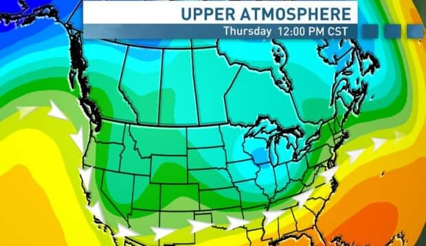
Usually, the jet stream bevels and bends as it makes its way around the world, but it has been unusually straight this past while. This straightness — also known as zonal flow — prevents warm air from being pulled north and arctic air from being dragged south.
With the overall flow of the atmosphere nearly stalling as a result, temperatures have stayed relatively consistent day after day.
The jet stream has also placed itself south of Canada, which has allowed consecutive storm systems to ride it and slam into states like California and Nevada.

The surface of the atmosphere has also been eerily quiet. This time of year low pressure systems usually pass by, bringing snow and wind. But with a lack of those systems, there's been nothing to "mix up" the atmosphere.
Foggy days and nights
This stationary pattern has allowed a temperature inversion to form.
"Generally, when you go up through the atmosphere from the surface … the temperature cools," said Terri Lang, a meteorologist with Environment and Climate Change Canada.
"In the case of an inversion, the temperature actually warms up [as you go higher]."

The inversion creates a sort of cap on the atmosphere near the surface, trapping everything inside.
"All the moisture, be it from open lakes or open rivers — we've [also] got sources of heat and moisture from industries and cars — that all gets trapped under the inversion," Lang said.
The moisture causes the fog that has blanketed the Prairies.
It's been so dense and lasted so long that parts of Saskatchewan have smashed average January visibility readings, including Kindersley, which has hit more than 120 hours of visibility less than one kilometre so far this month.
The January average there is 31 hours.
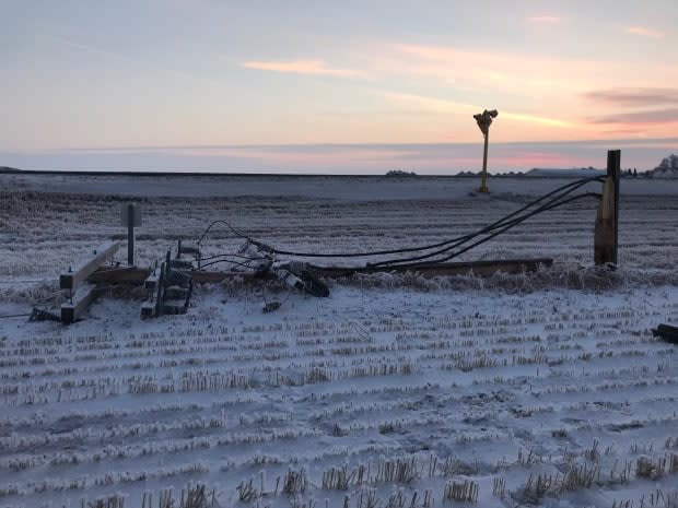
Beauty and danger in rime ice
Rime ice forms when fog occurs below freezing. The water droplets in the fog freeze, and if they freeze on things like tree branches, they create rime ice.

It can create beautiful scenes, but it also causes problems.
SaskPower spokesperson Joel Cherry told CBC that about 2,600 customers were impacted by outages caused by rime ice in parts of southern Saskatchewan Thursday morning.
Thousands of others have been impacted by similar outages this month alone.
Cherry noted lines can be damaged by trees weighed down by the ice landing on lines, or the lines themselves sagging because of ice buildup.
Power can sometimes be restored — if the line hasn't been broken — by reactivating it remotely. Crews can also attempt to knock the ice off of the lines to prevent outages in the first place.
"But right now it's a pretty widespread issue in the province and a lot of our lines have ice on them," said Cherry.
Pollutants from larger centres have also become trapped under the capping layer in the atmosphere. That drastically increased the Air Quality Health Index to a reading of eight out of 10 in Edmonton earlier this month — meaning people with health issues were advised to avoid outdoor activities.
Levels have also been slightly elevated in Saskatchewan and Manitoba.
Pattern change ahead
While much of Alberta appears to have broken free of the cloud and fog, Saskatchewan and southern Manitoba will have to wait until the weekend to see widespread clearing.
A ridge building in the jet stream will help keep temperatures warm, and a more westerly flow in the atmosphere will usher in drier air, eliminating the fog.
Wind is expected to make a return across the Prairies in the week ahead, with temperatures staying above average through much of the week.

