
Harsh cold front brings sudden freeze and travel troubles to Quebec

Brace for a quick snap back into winter reality on Wednesday, as a strong cold front swings into Quebec, bringing rain and thunderstorms to start, and a dangerous flash freeze to end.
A widespread flash freeze warning is in effect as the sudden drop in temperatures could result in icy roads, streets and sidewalks. For some, temperatures could drop by 10 to 15°C in just a matter of hours.
SPRING 2024: Get an in-depth look at the Spring Forecast, tips to plan for it, and much more!
Wednesday: Thunderstorm threat ahead of a rapid freeze
Rounds of showers and even some embedded thunderstorms are possible for southern Quebec through Wednesday afternoon. Despite being rare for this time of year, these storms are expected to remain non-severe in nature with periods of heavy rain, strong winds, and even small hail all a possibility.

Winter will then make a sudden return by the evening hours. That's as winds pick up, and an Arctic air mass takes over. Strong gusts between 60-80+ km/h are possible, which could lead to localized power outages.
Expect a quick transition from rain to accumulating snow, with snow squalls expected across western sections of the province. Visibility will be greatly reduced in the areas that see blowing snow.

The quick and sudden temperature drop will also heighten the threat for a flash freeze.
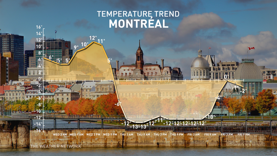
Temperatures in Mont Laurier and Gatineau will drop by 10-15°C in just a three to four-hour period Wednesday afternoon and evening, with the same temperature drop expected for Montreal Wednesday night.
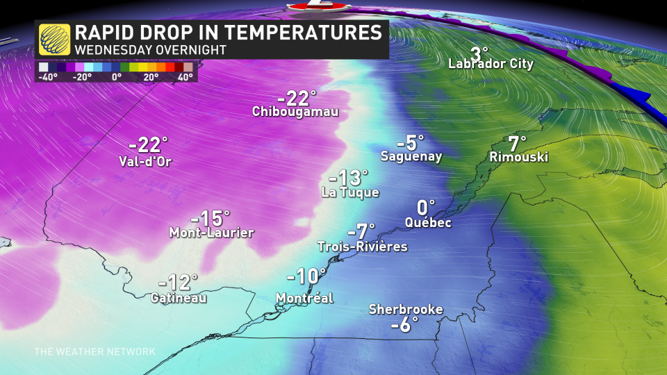
With the milder temperatures, rain, and snow melt ahead of this cold front, icy conditions are expected across the province as the colder temperatures will quickly freeze everything up.
Beware of sudden icy surfaces and black ice developing on wet roadways.
DON’T MISS: Earth just experienced its hottest 12 months in recorded history
New February records set Tuesday
Just like what Ontario experienced, Tuesday saw thunderstorms infiltrate western Quebec, alongside mild temperatures.
In fact, Mont-Tremblant and St-Anicet set new, all-time February temperature records.
Mont-Tremblant reached a high of 15.3°C, beating out its previous record of 11.8°C from 2000. St. Anicet hit an astounding 19.4°C on Tuesday, surpassing its old record of 17.0°C from 2017.
The warmer weather will return to the province by the weekend. Temperatures will soar well above seasonal into early next week, with high temperatures more typical of late April and possibly even early May. A few spots could even reach 20°C.
Stay tuned to The Weather Network for the latest forecast updates for Quebec.

