
Hay River, Fort Smith still safe after 'extremely challenging' day: fire officials

The out-of-control wildfire threatening Hay River, N.W.T., is encroaching even further on the community after what fire officials are calling an "extremely challenging" day of firefighting Saturday.
But crews successfully kept the fire back from structures for a second day as high winds continued.
The wildfire is now half a kilometre west of Hay River's industrial area, and half a kilometre from West Point First Nation along the West Channel. It is still one kilometre west of the airport.
It also burned within 100 metres of Highway 2, but air tankers kept it from reaching the highway.
In an update late Saturday night, N.W.T. Fire said the fire grew to the east, pushed past Birch Creek and into Wood Buffalo National Park.
The fire agency said Sunday is expected to bring four to eight millimetres of rain and favourable north winds, which would push the fire back on itself.
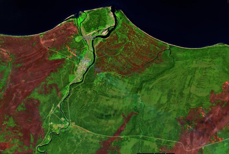
Satellite imagery shows wildfire actively burning a short distance from the town and West Channel. To the east, the wildfire has started to come up toward the shore of Great Slave Lake. (Sentinel-2/European Space Agency)
At last count, this wildfire has burned about 462,749 hectares of land — a little over 4,627 square kilometres. There are more than 220 people on the team fighting it, with 12 helicopters, 23 pieces of heavy equipment and at least 10 air tankers.
Fort Smith fire grows toward Thebacha
Meanwhile, fire crews working on the wildfire south of Fort Smith faced some extreme fire behaviour in areas Saturday as well, with high winds and clear skies.
Parks Canada said in a Saturday night update that the fire is now roughly half a kilometre from Thebacha, northwest of Fort Smith, and reached the Salt River in some places. It forced crews to fall back into safety zones after they ran sprinklers in the area.
They planned to have crews patrol the Thebacha road looking for spot fires throughout the night, in case the wind carried embers closer to the area.
Crews also had to pull back along Hay Camp Road south of Fort Fitzgerald as fire activity made the area unsafe in the afternoon and took down a lot of trees. In that area, the fire was mostly heading east toward the Slave River, Parks Canada said.

A helicopter flies through smoky skies over a flare-up on the wildfire threatening the Fort Smith area. (Fort Smith Protective Services/Facebook)
The update said there had been no reports of the fire breaching containment lines south of Fort Fitzgerald.

