
Beryl brings heavy rain, severe storm threat to Ontario, Quebec
Remnant moisture associated with the once powerful, and deadly Hurricane Beryl is making its way through Ontario and Quebec, bringing torrential, and potentially flooding rains.
Rainfall warnings and special weather statements are in place.
"Heavy downpours can cause flash floods and water pooling on roads. Localized flooding in low-lying areas is possible," Environment and Climate Change Canada (ECCC) says. "If visibility is reduced while driving, slow down, watch for tail lights ahead and be prepared to stop."
Pay close attention to the latest alerts and have a plan in place to seek safe shelter in case severe weather arises while at home, your office, or while you’re driving.
Soaking rains hit as Beryl remnants track through
Rainfall warnings and special weather statements cover most of southern Ontario and Quebec, with the threat for very high precipitation rates due to torrential downpours. The beginnings of the moisture-packed low came through extreme southwestern Ontario Tuesday overnight, ramping up Wednesday morning as the rain moved east. Eastern Ontario, including Ottawa, and Quebec, including Montreal, can expect to see rainfall by early Wednesday afternoon. It will file in from the south, through the Ohio Valley, over Lake Erie, and move northward in waves through Thursday.
Rainfall amounts are likely to be highly variable, but with some of the harder hit areas threatened with 75-100+ mm by the time all is said and done. The intense rainfall rates could impact travel, with drivers being urged to leave plenty of extra time for commuting. Avoid driving through flooded roads, especially underpasses.

"Heavy rains can cause flash flooding and ponding of roads. Local flooding is possible in low-lying areas," says Environment and Climate Change Canada (ECCC) in the rainfall warning. "If visibility is reduced while driving, slow down, watch the taillights of vehicles ahead and be prepared to stop."
WATCH: Here's what Beryl's remnants are bringing to Ontario Wednesday
Check out The Weather Network’s hurricane hub for all the latest on storms near Canada and around the world
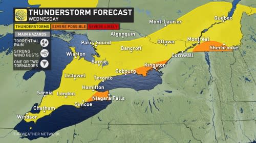
Severe thunderstorm threat, with risk of strong winds and large hail
While driven by an upper-level trough, at the surface, the system will send a warm front through southern Ontario and Quebec. Around this front is where we expect to see the heaviest rain fall, as well as the risk of severe thunderstorms. Through this afternoon dry pockets in the precipitation will allow for some instability to build.
The southwestern and eastern shores of Lake Ontario, as well as the eastern shores of Lake Erie and Niagara region, are at greatest risk of seeing severe storms develop.
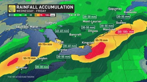
In terms of rain totals, between 50-75+ mm of rain is expected across Ontario's Bruce Peninsula, the shores of Lake Huron through to Windsor, and Price Edward County to Cornwall. Across the Greater Toronto and Hamilton Area and through cottage country, and towards Ottawa, between 30-50 mm is forecast.
Montreal can expect to see 50-75 mm of rain, with the Eastern Townships picking up between 50-100+ mm.
Flood risk
This type of weather system can produce very high precipitation rates due to torrential downpours. Remember, turn around, don't drown.
Toronto and Region Conservation Authority (TRCA) has issued a flood watch.
"The public is urged to stay away from streams, rivers, and shoreline areas. Avoid all recreational activities in or around water at this time, including fishing, canoeing, hiking, etc., as conditions can change rapidly," says the TRCA. "Exercise caution if you must be around any bodies of water, rivers or streams as well as the Lake Ontario shoreline."
The localized flooding from heavy downpours could also cause a significant amount of storm water runoff to make its way into Lake Ontario, raising the lake's pollution levels.
DON'T MISS: Six tips to manage flooding
WATCH: Beryl remnants bring heavy rain, thunderstorms to Ontario
Pleasant weekend ahead
The rain ends from west to east across southern Ontario through Thursday, tapering to showers by Thursday evening in southern Quebec.
Friday will be mostly sunny and very warm, with the weekend looking rather promising at this point. Saturday and Sunday should be mostly sunny with a low risk for scattered showers and thunderstorms, but many places should remain dry.
WATCH: Destructive scenes as Hurricane Beryl sets record in the Atlantic
Stay with The Weather Network for more forecast information and updates on your weather across Ontario and Quebec.

