
Blizzard conditions possible as snowy storm scrapes the East Coast

It’s officially spring by all accounts, but wintry weather is hanging tight across the East Coast as a series of storms hits the region to end the month of March.
MUST SEE: A trio of storms will showcase what a Canadian spring is all about
Snow that began across the Maritimes on Thursday will continue into Friday for many areas, with rain for some areas in the south and a healthy blanket of snow for much of the region.
By the end of the storm on Friday, we’ll see total accumulations of 5-15 cm of snow in central New Brunswick, with 15-20 cm possible in Prince Edward Island. The heaviest swath of snow with this system will fall across northern New Brunswick and eastern Cape Breton, with 15-25 cm expected through Friday.
The rain won’t amount to much, with 10-20 mm forecast in southern New Brunswick and the western half of Nova Scotia.

RELATED: Spring flooding in New Brunswick: Don't let your guard down
Snow will reach Newfoundland on Friday as the low tracks south of the island. This southerly track will focus the snow on the Avalon Peninsula, where accumulations could reach 15-25+ cm by Saturday. Forecasters expect 5-15 cm of snow for central and western Newfoundland, with 10-15 cm falling on the Bonavista Peninsula.
Winter storm warnings are in effect for much of southeastern Newfoundland, including the Avalon and Bonavista Peninsulas.
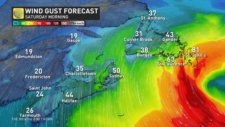
Drivers are being urged to plan accordingly because this storm will intensify just as it tracks south of the region, generating powerful, long-lasting wind gusts across eastern sections of the island.
Through Friday afternoon, coastal areas of the Burin and southern Avalon Peninsulas will see gusts over 80 km/h. Those gusts will spread across the entire Avalon by Friday evening.
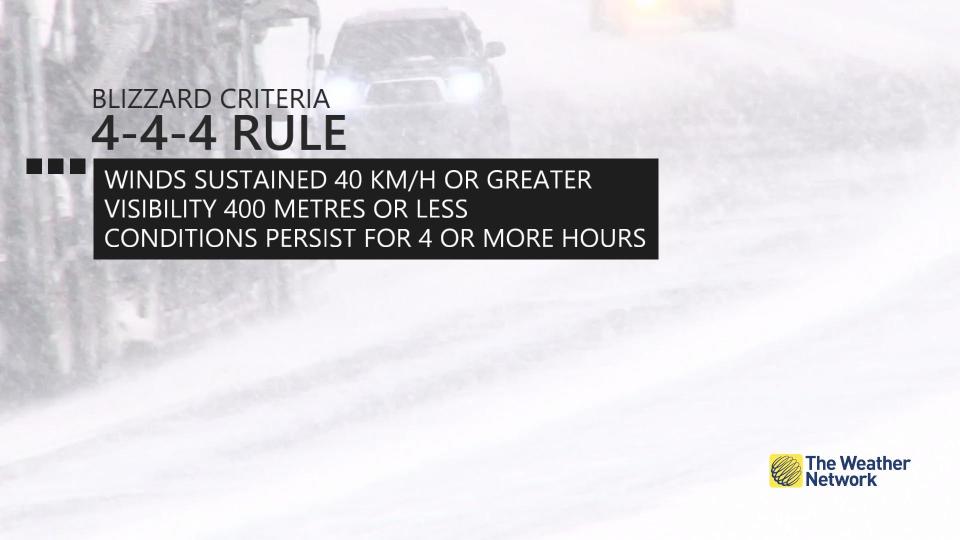
Winds will gust between 70-90 km/h across the Avalon on Saturday, creating a setup for a prolonged period of dangerous blizzard conditions from Friday into Saturday.
Travel will be hazardous at best.
While snowfall will have ended by Saturday afternoon for most on the island, a continued onshore northeast flow will generate additional snowfall, creating reduced visibility and pounding surf along coastal areas. It'll be Saturday night before conditions improve.
The next system will begin pushing into the Maritimes just as the snow winds down on Newfoundland on Saturday night. This second system will bring primarily snow to the Maritimes Sunday into Monday.
The final few days of March will bring widespread snow as yet another strong low-pressure system tracks through the region.

Be sure to check back for the latest forecast updates across Atlantic Canada.

