
Heavy snow, rain prompt widespread warnings across Atlantic Canada

Southerly flow will transport an abundance of tropical moisture straight to the East Coast in the coming days, combining with a complicated atmospheric setup to spark a long-duration mix of rain, snow, and ice for the Atlantic provinces.
The first of these systems is the same storm responsible for bringing disruptive snow to parts of Ontario and Quebec on Friday, with parts of the Maritimes seeing its impacts through the morning as well.
As of early Friday, some hefty accumulations had already been reported in parts of central New Brunswick. In all, between 20-40+ cm of snow could hit the hardest hit areas with this storm.
About 25cm of new snow in far West Fredericton this morning. #NBStorm pic.twitter.com/Qpfswm9zD6
About 25cm of new snow in far West Fredericton this morning. Dave Robins on Twitter: "About 25cm of new snow in far West Fredericton this morning. #NBStorm pic.twitter.com/Qpfswm9zD6 / Twitter" Dave Robins on Twitter: "About 25cm of new snow in far West Fredericton this morning. #NBStorm pic.twitter.com/Qpfswm9zD6 / Twitter"
— Dave Robins (@southernon_wx) Dave Robins on Twitter: "About 25cm of new snow in far West Fredericton this morning. #NBStorm pic.twitter.com/Qpfswm9zD6 / Twitter"
MUST SEE: Here's what you need, indoors and out, to get through winter
A widespread winter storm warning is in effect for the province, with driver's being urged to consider postponing non-essential travel. New Brunswick's RCMP have also recommended against travel, with extremely poor and deteriorating conditions reported.

The snow will continue across the region before a transition over to rain through Friday afternoon. A risk for freezing rain develops Friday afternoon as well, with the greatest threat extending north of Fredericton in central and northern New Brunswick.
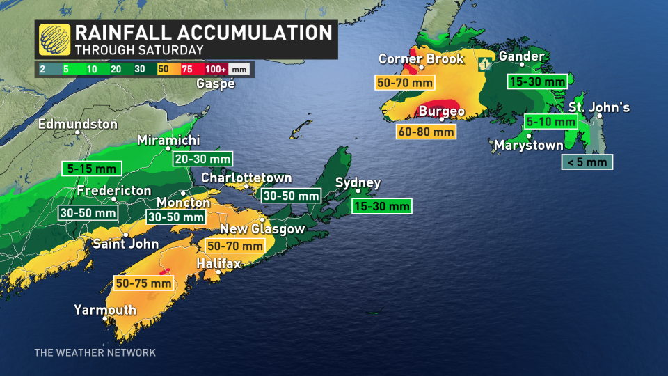
Warmer air in place will make this mostly a rainy affair for Nova Scotia, eastern Prince Edward Island, and southern New Brunswick, where up to 100 mm of rain is possible through Saturday across the hardest-hit areas. Rainfall warnings are in effect.
"Heavy downpours can cause flash floods and water pooling on roads. If visibility is reduced while driving, slow down, watch for tail lights ahead and be prepared to stop," says Environment and Climate Change Canada (ECCC) in the warning.
Precipitation will ease across the Maritimes overnight Friday into early Saturday morning.
Across the gulf, much of western Newfoundland finds itself under a winter storm warning as a messy combination of rain, freezing rain, and snow threatens to create hazardous travel conditions across parts of the island Friday afternoon through Saturday morning.
From Port aux Basques to Francois, between 15 to 20 cm of snow is expected on Friday, before transitioning over to heavy rain.
More than 100 millimetres of rain is possible from Friday through Sunday, heightening the risk for flooding due to an inability for the frozen ground to absorb water.
"Similar storms in the past have caused road washouts and closures, elevated river levels, and flooding of properties, especially in poor drainage areas," ECCC warns.
Looking beyond this system, a boundary setting up across the Maritimes and Newfoundland will serve as the focus for additional rounds of precipitation beginning Saturday night and arriving in waves through early next week.
Precipitation forming along the boundary will encounter a complicated mix of temperatures throughout the atmosphere, allowing for the whole spectrum of rain, freezing rain, ice pellets, and snow to fall across the region.
Prepare for continued travel disruptions through early next week, and continue checking back through the weekend for the latest details on the snow and ice threats across Atlantic Canada in the coming days.
Stay with The Weather Network for the latest on conditions across Atlantic Canada.

