
Heavy rains persist as tropical moisture washes over East Coast

Rainfall warnings continue across Atlantic Canada as a persistent slog of drenching rains wash across the region over the next couple of days.
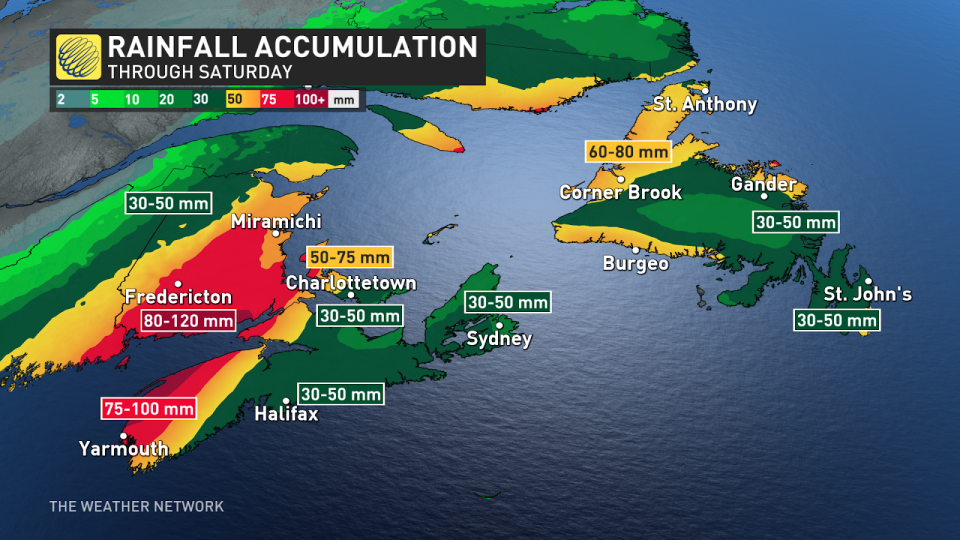
Some communities will see as much as 75-120 mm of rain in the gauges by the time precipitation finally lets up on Saturday. Soils are already soaked by recent rains, and additional heavy rainfall could lead to a threat for localized flooding.
Forecasters are watching the potential for rain to change over to snow in spots as cold air wraps into the region by Friday night. Windy conditions arriving Saturday could lead to scattered power outages.
RELATED: Storm washes out roads, leaves thousands in New Brunswick without power
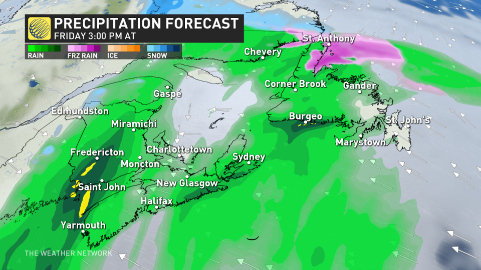
Friday and Saturday: Heavy rain persists
There’s a bit of evaporated paradise in the air over Atlantic Canada this week. Two plumes of tropical moisture are fuelling these ongoing heavy rains.
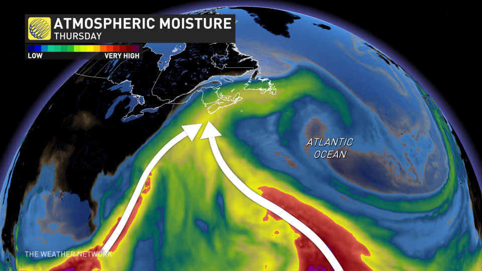
A boundary parked over the East Coast and an approaching low-pressure system will both continue wringing this moisture out in the form of heavy rain through Friday and Saturday.
Rainfall warnings remain in effect from the Bay of Fundy north to Newfoundland’s Great Northern Peninsula.
Folks in and around Halifax are on track to pick up 30-50 mm of rain from this system. The heaviest rain will fall over western Nova Scotia and southern New Brunswick, where 75-120 mm of rain should fall through Saturday.
Portions of the Maritimes that experience excessive rainfall are at a heightened risk for flooding over the next few days—especially given the storm we saw last weekend.
Across the Gulf, rainfall totals of 60-80 mm will be common across southern and western Newfoundland through Saturday. The Avalon Peninsula should see 30-50 mm from this system.
WATCH: River watch is underway in New Brunswick as warmer weather approaches
An important area to watch will be around the lower Saint John River. Due to ice jams and their unpredictable nature, it's hard to tell what the river levels will be like between Perth-Andover and Woodstock with this rainfall event.
River levels are forecast to reach a critical threshold around New Brunswick's Nashwaak and Durham Bridge in the coming days, so be sure to regularly check for public alerts and advisories if you are in this area.
According to Environment and Climate Change Canada (ECCC), comparable systems have caused dangerous road conditions, including erosion of road shoulders, and roads washed away by water.
"Torrential rains can cause flash flooding and accumulation of water on roads," says ECCC in the warning. "Flooding is possible in places in the lowlands."
WATCH: Dramatic animation shows dangers of driving through floodwater
Remember to never drive through flooded or washed-out roadways, as this could cause your vehicle to stall and put you in a dangerous situation.
A centre of low pressure will approach the Maritimes late Friday into Saturday, leading to more widespread rains and the arrival of gusty winds by early Saturday.
Winds could gust between 60-90 km/h by early Saturday morning. The combination of gusty winds and rain-soaked soils could result in scattered power outages.
Risk of some significant snow as temperatures cool into Saturday
A band of significant snow is expected to develop on the back side of the storm, possibly impacting eastern Quebec and western New Brunswick for the start of Easter weekend.

Although exact snowfall totals are still uncertain, snowfall totals of 10-20 cm are possible in New Brunswick, with the potential for higher totals if snowfall rates are heavier.
Conditions will remain blustery and cool behind this system, with yet another messy system eyeing the region for the middle of next week. Some wintry weather is possible again with this next system.
WATCH BELOW: New pilot program uses batteries to keep power on during a storm
Be sure to check back for the latest updates across Eastern Canada this week.

