
High impact storm threatens ice, 20+ cm of snow over parts of Ontario
For many across southern Ontario, the first significant winter storm of the season is on the doorstep, prompting widespread special weather statements warning of serious travel complications for Thursday and into Friday. With hefty amounts of snow and ice expected for some, along with blustery winds, Environment and Climate Change Canada (ECCC) has urged people to "consider postponing non-essential travel until conditions improve."
DON'T MISS: Blizzard, twisters likely as 3,000 km-long storm eyes Canada, U.S.
A strong Colorado low will bring basically everything but the kitchen sink with significant snowfall, ice, wind and rain set to impact southern Ontario.
The storm setup is quite complex due to the developing of a second low late Thursday into Friday across the northeastern U.S. Temperatures will also highly impact whether precipitation will fall mainly as snow or whether a wintry mix of freezing rain, ice pellets and rain stick around longer for some locations.
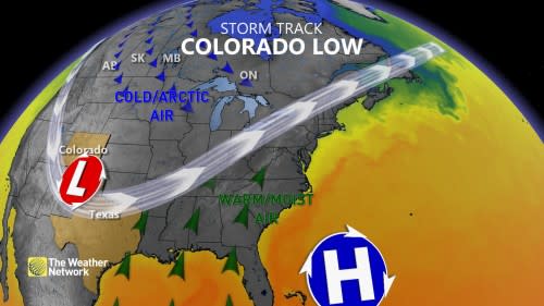
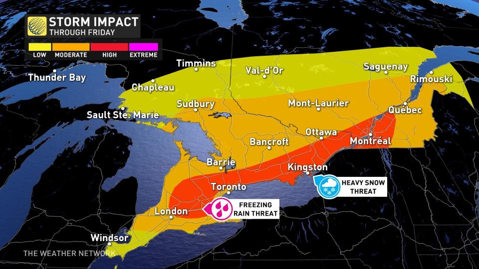
What we are certain of however, is that regardless of precipitation totals, this will be a high-impact event that will stretch impacts hundreds of kilometres in length and preparation ahead of time is necessary.
WATCH: 3 things major storm will bring to S. Ontario this week
Freezing rain
The system will start overnight Wednesday, hitting parts of southwestern Ontario with rain -- where precipitation will remain primarily as rain. By the pre-dawn hours on Thursday morning, parts of the Greater Toronto Area (GTA), London and Grey-Bruce County will have a chance to see some freezing rain and ice pellets.
"There is still a lot of uncertainty on the amount of freezing rain, but preliminary numbers look to be upwards of 2-5 mm of ice accretion," says Matt Grinter, a meteorologist at The Weather Network. "This could lead to slippery roads, isolated power outages, and light damage to small trees."
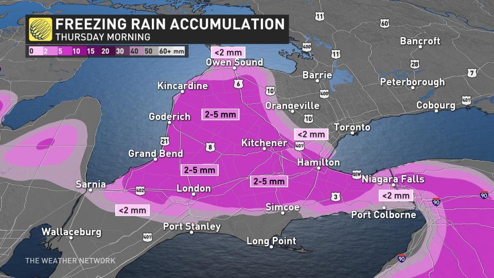
There will be the chance for some ice pellets as well, but this won't be a big risk.
Snow
Snow is expected to begin late Thursday morning and become heavy at times. Lesser snowfall amounts are expected near Lake Ontario where snow may transition to rain.
Between 5-15 cm of snow is possible for the GTA lakeshores as well as the Niagara region. Away from the lakes across the GTA, as much as 10-25 cm may fall.
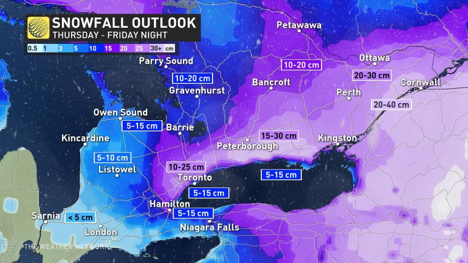
Across eastern Ontario, the heaviest accumulations are expected, including the city of Ottawa where 20-30 cm of snow is currently forecast.
"Thursday evening the snow and mixing continues for the GTA and parts of southwestern Ontario as eastern Ontario is fully engulfed in snow," says Grinter.
SEE ALSO: Your winter storm preparation checklist
Hazardous travel conditions expected due to heavy snow, including for the Thursday evening and Friday morning commutes. Consider postponing non-essential travel until conditions improve.
Winds
In addition to the snow and ice will be the winds. Southeasterly wind gusts up to 70 km/h are possible, particularly near Lake Ontario. Gusts between 60-80 km/h could also impact areas near and along Lake Huron and Georgian Bay.
Loose objects may be tossed by the wind and power outages may occur.
Wind gusts will pick up Wednesday overnight, peaking through the day on Thursday.
WATCH: Heavy impacts to commute times through Thursday
Look ahead: Lake-effect snow develops, eyeing another potent storm next week
Bands of lake-effect snow are likely this weekend east of the Great Lakes.
Forecasters are also watching the potential for another significant storm mid-to- late next week. Frigid weather is expected for Christmas, Boxing Day and beyond -- for the final week of 2022.
Check back for the latest on the forecast across southern Ontario.

