
High winds, tropical moisture en route to sweep Atlantic Canada
It’s a late-weekend storm with pizzazz. Born in the bayous and feasting on tropical moisture, the system is a triple-threat of high winds, heavy precipitation, and headaches from Louisiana’s Acadiana to the Maritimes’ Acadia.
It’s a Texas low, and it’s going to bring some foul weather to the Atlantic provinces heading into next week.
Going somewhere? Check out the current highway conditions before heading out!
For folks south and west, this developing low-pressure system has been one of the more enigmatic storms we’ve had to deal with recently. Weather models are struggling to get a handle on it, which is no small issue given that it could bring heavy snows to some Canadians and a risk for severe thunderstorms to folks down in the States.
What is clear, though, is that the storm will make its way into Atlantic Canada on Sunday and Monday with a threat for high winds, heavy rains, and a finishing garnish of snow as it pulls away from the region.
Mild air arrives on wicked southerly winds
Temperatures in December climbing into the teens with a touch of humidity in the air is usually a sign that something is amiss in the atmosphere.
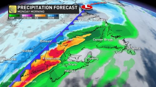
The heart of our Texas low will scoot north through Quebec on Sunday and head into Labrador on Monday. A long cold front trailing off the southern end of the system will gradually drag across the Maritimes beginning late Sunday and into early Monday morning.
Stout southerly winds feeding into this storm will drag tropical moisture, mild air, and forceful wind gusts across the Maritimes and Newfoundland before the cold front pushes through later in the day Monday.
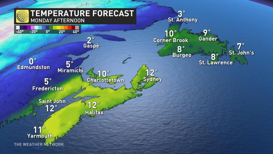
Daytime temperatures will easily rise into the teens across Nova Scotia, the Fundy shores of New Brunswick, and much of Prince Edward Island. Predicted highs of 12°C in Halifax and 10°C in Charlottetown are about ten degrees above seasonal for this time of year.
Those mild winds won’t arrive peacefully. Gusts of 100+ km/h will buffet the Maritimes through the day Monday ahead of the cold front’s arrival. A period of gusts between 100-110 km/h is likely Monday afternoon across southern Nova Scotia and the Bay of Fundy. Folks along the coast will experience the stiffest wind gusts.

Take a moment this weekend to secure or bring inside any holiday decorations that may blow around in Monday’s high winds. Inflatable yard decorations are particularly vulnerable to taking flight on a windy day.
STAY SAFE: Be aware of your heart while shovelling heavy snow
While the winds are the biggest story, we’ll also have to contend with some heavy precipitation as the cold front passes through.
A slug of tropical moisture aloft will fuel a spell of heavy rainfall along and ahead of the cold front. The bulk of this rain will fall overnight into Monday. Cold air slipping in behind the front will bring snow to the Gaspé Peninsula and northern New Brunswick.
Temperatures will rapidly fall behind the cold front, with highs on Tuesday coming in much closer to the freezing mark. Conditions will remain around or just below seasonal for the remainder of the week.
Stay with The Weather Network for all the latest on your forecast across Atlantic Canada.

