
Pattern will flip-flop on Ontario with temperature jump to mark fall's arrival
The pumpkins on the store shelves may say “it’s fall, y’all,” but the atmosphere has other plans for Ontario as we head toward the autumnal equinox on Saturday.
A stout ridge of high pressure looks to build over the eastern half of Canada toward the end of the week, potentially sending temperatures soaring double-digits above seasonal for this time of year.
MUST SEE: What a growing El Niño could mean for Canada’s upcoming winter
Folks who love cool weather should soak up the chill early this week, though.
Overnight lows will dip well into the single digits for northeastern Ontario, the Nickel Belt, and cottage country Monday night into Tuesday morning, with some areas potentially falling to the freezing mark by sunrise.

DON'T MISS: How the Great Lakes influence fall and winter weather in Ontario
Things are going to change in a hurry, though, as a pattern flip lurches across the region.
A large ridge of high pressure will build over Ontario and Quebec by the end of the week, allowing temperatures to soar far above seasonal as we approach the first day of fall on Saturday.
Ridges foster sinking air, which warms up as it falls toward the ground. This air will get quiet toasty for a large swath of Ontario.
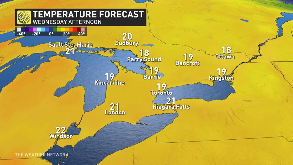
On Wednesday and Thursday, temperatures have the potential to reach the mid-20s in extreme southwestern Ontario, with low-to-mid 20s for the Greater Toronto Area (GTA) and west. There is the potential where temperatures could overachieve in some areas in the south if the winds do shift to be from the southwest bringing in warmer air.
DON’T MISS: A rare behemoth: Hurricane Lee’s incredible 9,000+ km journey
By Friday, some folks might see highs pushing the 30-degree mark, daytime highs well above seasonal for this time of year.

The warmth won’t remain confined to the south, either. We could see highs across portions of northern Ontario climb 10+ degrees above seasonal for the second-to-last week of September.
As we head into the weekend, milder air and dry conditions will continue to persist.
Stay with The Weather Network for the latest on conditions across Ontario.

