
Hurricane Beryl, super-charged by warm seas, stuns experts
Hurricane experts and meteorologists watched in shock over the weekend as Tropical Storm Beryl continued to strengthen quickly in the tropical Atlantic Ocean far earlier than storms typically do, with record-warm ocean temperatures helping it make history.
Within 24 hours after forming as a tropical depression, Beryl's winds had reached hurricane strength – 75 mph – by 5 p.m. Saturday, with an impressive form on satellite images.
The National Hurricane Center forecast projected Saturday afternoon that favorable conditions would help Beryl rapidly intensify to a major hurricane – with wind speeds up to 115 mph – as it reached Barbados and the fringe of islands that border the eastern Caribbean on Monday morning. Beryl exceeded their expectations, by a lot.
By 11:30 a.m. Sunday, Beryl had become a Category 4 hurricane, with winds of 130 mph. That's a gain of 95 mph in just 42.5 hours.
Once it moves into the Caribbean later Monday it will encounter another body of water historically warm for this early in the summer. The hurricane center expects it to remain a hurricane as it reaches Mexico's Yucatan Peninsula on Friday.
"If you asked the water in the Caribbean Sea what day it was, it would guess September 10,” said Brian McNoldy, a senior research scientist at the University of Miami’s Rosenstiel School, in a post on X Saturday morning.
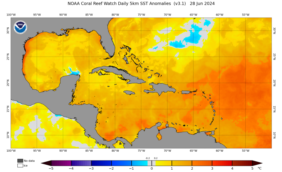
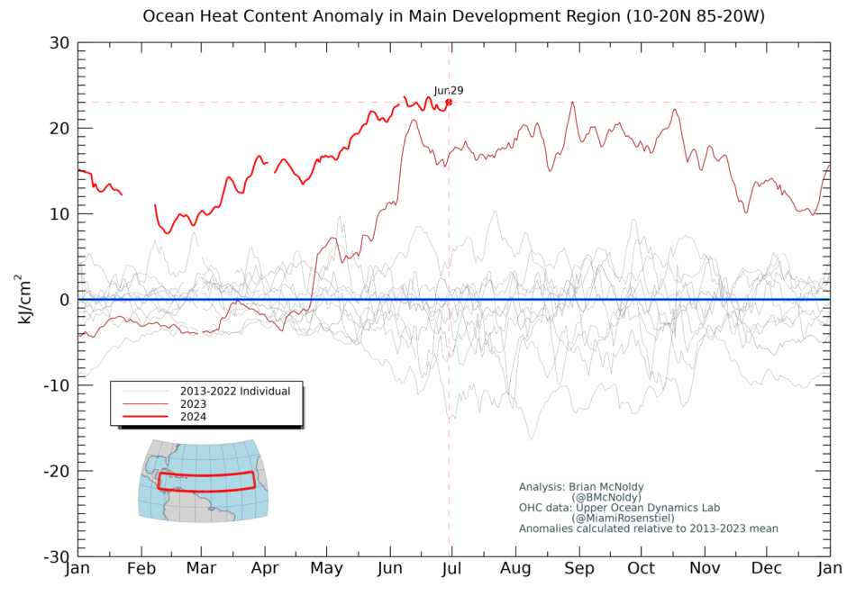
The warm ocean temperatures continue a record-breaking trend that began in May 2023. Like many scientists, McNoldy has been riveted by the exceedingly warm temperatures in the Atlantic Ocean, Caribbean Sea and the Gulf of Mexico. In June, he called the water temperatures in the region where hurricanes typically develop in the Atlantic “absolutely stunning.”
On Saturday, he posted on X: “You'd think the shock value of this would wear off, but it's becoming MORE shocking!”
So far in 2024, ocean heat content has been even hotter on most days than the records set last summer. That's dangerous for hurricane season because warm water is like a big, juicy energy drink for hurricanes, supplying warm moisture that helps fuel the inner core structure that makes storms stronger.
Seasonal forecasters warned in the spring that these hotter-than-normal ocean temperatures could play a major role in storm development this hurricane season. It’s the reason that all major outlooks called for a busier-than-normal season. The National Oceanic and Atmospheric Administration and Colorado State University both predicted more named storms this year than they’d ever predicted before.
Still, hurricane experts are reeling at the news that Beryl became a major hurricane by June 30, while still east of the Windward Islands.
How unusual is it to have an early hurricane?
On Saturday, Beryl became the strongest storm ever to form in the tropical Atlantic so far east of the Windward Islands in June, said Phil Klotzbach, a meteorologist and research scientist at Colorado State, in a post on X Saturday. However, it's worth noting, he said, that storm intensities so far out in the Atlantic may have been underestimated before the satellite era that began in 1966.
By Sunday morning, Beryl had become the third earliest major hurricane on record in the entire Atlantic region, trailing only Alma on June 8, 1966, and Audrey on June 27, 1957, Klotzbach said.
Since 1851, only two previous hurricanes on record have been within 100 miles of Barbados prior to August 1: Emily in 2005 and Elsa in 2021.
Across the Atlantic, only five major hurricanes, with winds of more than 111 mph, have been reported in the Atlantic Ocean before the first week of July, said Michael Lowry, a hurricane specialist at WPLG Local 10 News in Miami, in a post on X.
"It's astonishing to see a forecast for a major (Category 3+) hurricane in June anywhere in the Atlantic, let alone this far east in the deep tropics, " wrote Lowry, a former National Hurricane Center specialist.

Hurricane categories are set based on the Saffir-Simpson Hurricane Wind Scale, the lowest being a Category 1, with winds of 74-93 mph and the highest Category 5, with wind speeds of 157 mph or higher. Lowry said there's never been a Category 4 or Category 5 observed before July 8 when Hurricane Dennis reached that status in 2005.
What is rapid intensification?
It's a phenomenon that occurs when a storm strengthens by at least 35 mph in a 24-hour period. Beryl's winds increased by 40 mph in 24 hours after forming on Friday afternoon.
Beryl's winds increased by another 45 miles per hour in the 18 hours after the center's 5 p.m. forecast on Saturday.
Rapid intensification has been one of the biggest frustrations for hurricane forecasters. All four of the most destructive, Category 5 hurricanes to make landfall on the mainland U.S. over the past 100 years rapidly intensified.
For years, hurricanes would rapidly intensify with little to no warning, but today the technology for observing the environment around a hurricane and the ability to discern what may happen are better than ever, though still not perfect.
Scientists still aren't sure why some storms rapidly intensify, but they know it takes near-perfect atmospheric conditions inside and outside the storm.
How do hurricanes form? A USA TODAY visual story on the birth and power of ferocious storms
What's the forecast for Beryl in Haiti and Jamaica?
Beryl is forecast to move west-northwestward, passing near or over Haiti, Jamaica and Grand Cayman on Tuesday evening and Wednesday. Although it initially appeared that Beryl might lose strength quickly in the Caribbean, it's expected to remain a major hurricane through Wednesday.
Its wind speeds are forecast to decline as it moves through the Caribbean, thanks to windier conditions that are less conducive to helping Beryl maintain its strength. Winds can shear off or disrupt cloud tops in hurricanes, breaking up the powerful inner core that helps a hurricane reach the higher echelon of wind speeds.
However, the hurricane center warns there's large uncertainty in the forecast four and five days out, and residents and tourists in the central and western Caribbean should monitor Beryl's progress.
Why are water temperatures so warm?
Climate change driven by fossil fuel emissions has had a steady impact on the oceans, which have absorbed much of the excess warming for decades, scientists say.
This spring, weak trade winds helped reinforce the warmer-than-normal sea surface temperatures in the tropical Atlantic, Klotzbach said.
But the experts remain somewhat baffled by last year's sudden spike in temperatures and the ocean heat that continues to break records more than a year later. Their research continues.
Dinah Voyles Pulver covers climate and the environment for USA TODAY. Reach her at dpulver@gannett.com or @dinahvp.
This article originally appeared on USA TODAY: Record hot oceans driving Hurricane Beryl

