
Jamaica braces for Hurricane Beryl, slightly weaker but still a dangerous Cat 4 storm
Hurricane Beryl was downgraded to a Category 4 storm Tuesday afternoon and remained so into the night as it began to tangle with a patch of storm-weakening wind shear but it was still on track to slam into Jamaica as a dangerous major storm sometime Wednesday.
Beryl broke a new slew of records by strengthening overnight into a massive Category 5 hurricane — the earliest on record in July — and has already left behind a wake of death and destruction in the southeastern Caribbean.
By Tuesday afternoon, an expected decline in power appeared to be underway. The storm’s maximum sustained winds started to slow, a sign that Jamaica could see impacts from a slightly less intense windstorm. But the newest track also nudged the potential path of the eye even further north, meaning a direct landfall of a Category 3 or 4 storm was possible in Jamaica.
The National Hurricane Center said Beryl could bring sustained winds of 140 mph, 5 to 8 feet of storm surge and up to a foot of rain in Jamaica, sparking a hurricane warning for the island and a flurry of disaster preparations and evacuation warnings.
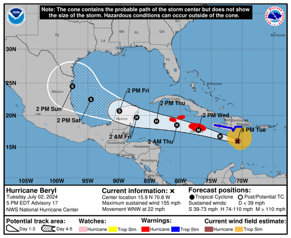
The latest forecast called for Beryl’s eye to pass across the southern coast of Jamaica as a Category 3 hurricane on Wednesday, then swipe south of the Cayman Islands as a Category 2 hurricane on Thursday before making landfall in Quintana Roo in the Yucatan Peninsula on Friday as a Category 1.
A large high-pressure ridge over Cuba, Haiti and the Dominican Republic is expected to do most of the work steering Beryl west and into a patch of storm-toppling wind shear on Tuesday and Wednesday.
“The Bermuda High remains in control,” wrote Sammy Hadi, a meteorologist with the Miami office of the National Weather Service, on X, the social media site formerly known as Twitter.
Taking a look at the big picture view of Major Hurricane #Beryl this morning.
Beryl is nestled between 25-40 knots of southwesterly wind shear just to the west thanks to an T.U.T.T. over Colombia & a large plume of Saharan Dust to the east. The Bermuda High remains in control. pic.twitter.com/mxCOCh3pCN— Sammy Hadi (@SammyHadiWx) July 2, 2024
Beryl’s tangle with Jamaica and the Cayman Islands, combined with that unfavorable wind shear, could further weaken the storm.
Earlier forecasts appeared to show Beryl slowing down even further, or even stopping, over the Yucatan, but the latest tracks suggest the storm could emerge in the Gulf of Mexico as at least a tropical storm and potentially find a new target for landfall over the weekend.
READ MORE: ‘The situation is grim.’ Hurricane Beryl shreds Caribbean islands, kills at least 4
“There remains a significant spread in the track guidance when Beryl emerges into the southwestern Gulf of Mexico, due mainly to model differences in the strength and location of a break in the subtropical ridge over the southern United States,” forecasters wrote in the 5 p.m. discussion.
As of the 11 p.m. advisory, Beryl was packing sustained winds of 150 mph and headed west-northwest at 22 mph. Hurricane-force winds extended 40 miles from the clearly-defined eye, and tropical-storm-force winds extended out about 185 miles from the center.
It was about 300 miles east-southeast of Kingston, Jamaica. The Meteorological Service of Jamaica said Beryl’s outer bands are expected to reach the country by daybreak Wednesday. On its way, the eyewall is expected to move south of Haiti.
Hurricane warnings were in effect for Jamaica and the Cayman Islands. The government of Mexico issued a hurricane watch for the east coast of the Yucatan Peninsula, from Chetumal to Cabo Catocha, according to the National Weather Service.
Jamaican Prime Minister Andrew Holness on Tuesday night declared an islandwide curfew from 6 a.m. to 6 p.m. Wednesday. Additionally, evacuation orders were in effect for flood-and landslide-prone areas of the country.
“We urge all Jamaicans to comply with notices to evacuate,” Holness said in a statement. “Even without a notice, if you live in a low-lying area or near a river or gully, evacuate to safer ground.”
Four deaths, lots of damage
In Beryl’s wake, residents of the eastern Caribbean islands slammed by the fast-moving and hard-hitting storm were assessing damages on Tuesday.
Particularly hard hit is St. Vincent and the Grenadines’ Union Island, where at least one death has been reported. Three other deaths also were reported, including two in Grenada.
Multiple reports suggest 90% of the houses and businesses on Union island have been destroyed. The islands of Carriacou and Petite Martinique, where Beryl’s eye made landfall on Monday, reported 95% of homes were uninhabitable.
“The situation is grim,” Grenada’s Prime Minister Dickon Mitchell said in a morning press conference. “There’s almost complete destruction of homes and buildings on the islands. The roads are not passable and in many instances cut off because of the large quantity of debris strewn all over the streets and obviously the danger posed by down power lines.”
Drone video captured by storm chaser @bclemms shows scenes of devastation on the island of Carriacou after Hurricane Beryl slammed into the coast as a Category 4 storm. pic.twitter.com/c2VMJh2o5i
— AccuWeather (@accuweather) July 2, 2024
With Beryl expecting to bring life-threatening winds and storm surges to Jamaica, the government has activated disaster preparedness and its response mechanisms in anticipation of the hurricane’s passage. The government publicized the locations of 800 shelters throughout the country but has not opened them yet.
The Norman Manley International Airport in Kingston is set to close at 9:45 pm Tuesday with its last scheduled flight and will remain closed on Wednesday as the island locks down.
The eastern Caribbean also remains on guard against another potential tropical system, a disturbance that the hurricane center is tracking in the central Atlantic.
On Tuesday afternoon, the hurricane center continued its trend of lowering the system’s chances of formation anytime soon, this time to a 20% shot over the next week and a 10% chance of strengthening into a tropical depression in the next two days.
“Environmental conditions are only marginally conducive for development of this system,” forecasters wrote. “Interests in the Lesser Antilles should still monitor the progress of this system, with heavy rainfall possible midweek.”
Miami Herald staff writer David Goodhue contributed to this report.

