
Hurricane experts push forward with aggressive forecast despite slow start to season
FORT COLLINS, Colo. – The Atlantic hurricane season is still forecast to be extremely active this year despite a quiet start so far, according to the latest outlook released Tuesday by researchers at Colorado State University (CSU), where seasonal forecasts were pioneered 40 years ago.
Dr. Phil Klotzbach, a senior research scientist at CSU, and his team are maintaining their original forecast from April that calls for 23 named storms, of which 11 would become hurricanes. Five of those storms could reach major hurricane status of Category 3 or higher on the Saffir-Simpson Hurricane Wind Scale.
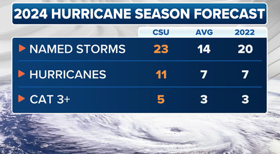
"The team again cites very warm sea surface temperatures in the tropical and eastern subtropical Atlantic as a primary factor for their active season prediction," the report stated. "Eleven hurricanes is the highest predicted number of hurricanes that CSU has ever issued in a June outlook. The prior high was for 10 hurricanes in 2010 (when 12 were observed) and in 2022 (when eight were observed)."
An average season would expect just 14 named storms, seven hurricanes and three major hurricanes.
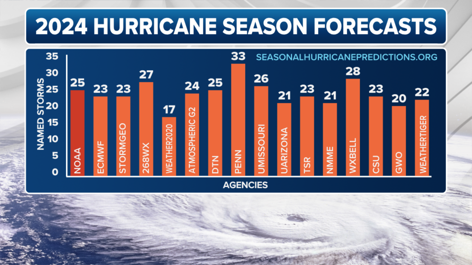
CSU joins NOAA and 14 other forecasting agencies and computer models in predicting an above-average hurricane season – and in some cases, a well-above-average season.
NOAA ISSUES ITS MOST AGGRESSIVE HURRICANE FORECAST ON RECORD
Most are predicting around 20-25 named storms – which would nearly or totally exhaust the list of 21 names for the 2024 season and require using a new supplemental hurricane name list.
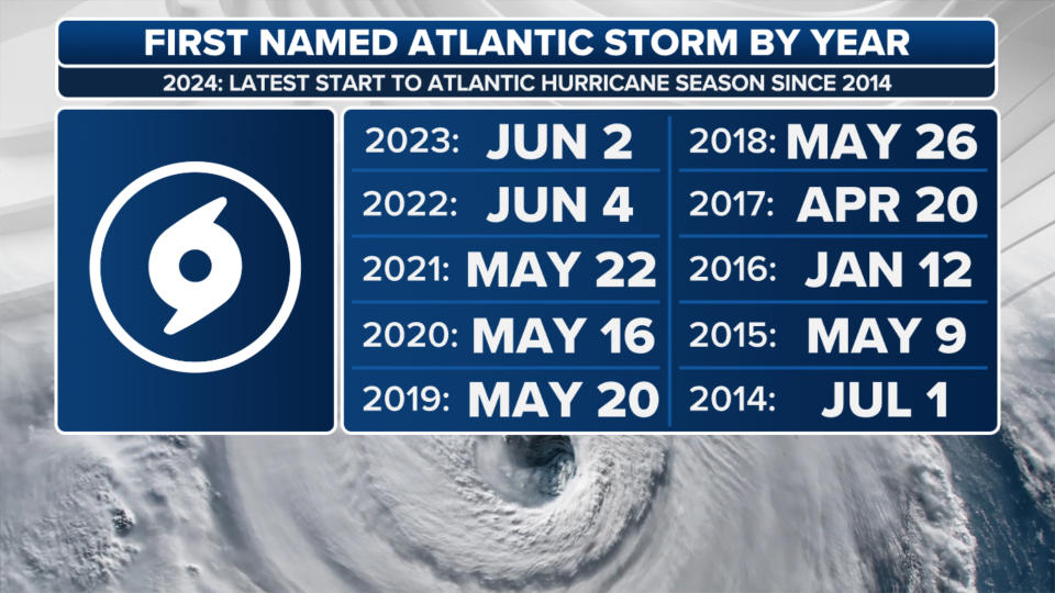
With no named storms now through June 11, it’s still the latest the Atlantic Basin has gone without its first named storm in a decade. The 2014 hurricane season took the entire month of June off, with Tropical Storm Arthur waiting to form until July 1 as the season’s inaugural named storm.
But the current situation in the Atlantic can probably best be described as a powder keg waiting to explode. Mother Nature has just yet to find the match. The heat content of the Caribbean water is already as high as we normally see it in September.
2024 ATLANTIC HURRICANE SEASON GUIDE: HERE’S WHAT TO KNOW ABOUT THIS YEAR’S STORMS
"(Ocean) temperatures are 2-3 degrees above normal, and we’ve seen these warm anomalies almost over the entire North Atlantic Basin going all the way back into 2023 continuing with at or near-record warm temperatures," National Hurricane Center (NHC) Director Michael Brennan told FOX Weather in an interview last week. "So the ocean is certainly primed for a busy hurricane season, but it needs the atmosphere to go along and cooperate."
A budding La Niña event is expected to oblige, as it would decrease vertical wind shear – the change in wind speed and direction with height – in the Atlantic that would normally thwart tropical system development.
ATLANTIC HURRICANE SEASON OFF TO SLOWEST START IN A DECADE
"Lower vertical wind shear is a bad thing, and we may be looking at record-low values of wind shear as we head into the peak of the season," Brennan said. "And that’s going to allow developing systems to take advantage of these very favorable warm ocean conditions."
And the CSU team agrees.
"Given the combined hurricane-favorable signals of an extremely warm Atlantic and the absence of El Niño, the forecast team has higher-than-normal confidence in this outlook that the 2024 Atlantic hurricane season will be very active," CSU researchers wrote.
The research team also maintains their landfall probabilities for hurricane strikes, giving a 62% chance of a hurricane landfall for the entire U.S. coastline (the average from 1880-2020 is 43%). Digging deeper, the team gives a 34% of a hurricane landfall for the U.S. East Coast, including the Florida Peninsula, a 42% chance along the Gulf Coast and 66% chance for the Caribbean – all above historical average probabilities.
CSU HURRICANE OUTLOOK SHOWS WHICH STATES COULD BE THREATENED IN 2024
In the interim, other atmospheric factors have combined to squelch tropical development. A massive heat dome in Central America brought sinking air and wind shear to the Gulf of Mexico and the northern Caribbean, where we would typically expect to see tropical development in June.
In addition, dry, smoky air from wildfires burning in Central America has drifted into the Caribbean at times, surpassing tropical development.
BRYAN NORCROSS: POSSIBLE DEVELOPMENT OFF THE SOUTHEAST COAST
But there are signs conditions are about to become more favorable for tropical development in the Gulf of Mexico.
Already this week, the NHC is monitoring disturbance Invest 90L in the Gulf of Mexico for potential tropical development after it crosses Florida and emerges over the southwestern Atlantic.
After this weekend, there is a better signal in the Gulf of Mexico for perhaps a tropical depression or weak tropical storm sometime early next week.
A strong area of wind shear currently limiting development in the Gulf is expected to wane next week as an upper-level high builds in. It's better conditions for tropical development if an area of low pressure is able to form under the high pressure area.
"A pocket of atmosphere conducive to tropical development is forecast to develop in the western Gulf next week," says FOX Weather Hurricane Specialist Bryan Norcross. "Long-range computer forecasts indicate a chance of tropical development, but it's too far out for any certainty. But now that the door to the Caribbean appears to be opening, we'll watch for development farther south, as well as in the Gulf of Mexico."
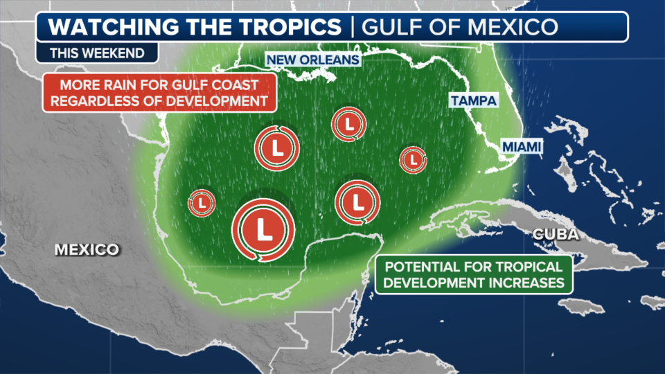
Regardless of any tropical development, an area of deep tropical moisture soaking Florida this week is forecast to shift away from Florida and become oriented toward Texas or the northern Gulf Coast. If so, the weather pattern could bring heavy rain and potential flash flooding to the region starting Sunday.
"Stay alert for flood alerts issued for your local area, especially later this week," Norcross said. "The southern peninsula is in a drought condition, so initially, the ground will absorb the water, but that might not be the case after a day or two of downpours."
Tropical history is littered with seasons that began late and still went on to be above average … and devastating.
The historically busy year of 2005, which included Hurricane Katrina, saw a whopping 27 named storms plus another unnamed storm that season, despite Tropical Storm Arlene not forming until June 9.
The 1998 season, which produced the catastrophic Category 5 Hurricane Mitch, as well as devastating hurricanes Georges, Bonnie and Earl, didn't begin until Alex was named on July 27.
"On average, the first named storm of the year usually doesn’t form until mid- to late June, so it’s not unusual to be quiet so far," Brennan said. "The vast majority of hurricane activity and most of the major hurricanes occur during those months of August, September and October. And that’s what we’d expect to see this year with those warm ocean temperatures and the developing La Niña."
CSU's team says they will issue updated forecasts on July 9 and Aug. 6.
Original article source: Hurricane experts push forward with aggressive forecast despite slow start to season

