
Northeast under risk of damaging wind, flooding and tornadoes

More than 80 million are in the storm zone this weekend, with the potential for damaging wind, tornadoes and heavy rainfall.
More than 8 million are under a flood watch for parts of Ohio, Pennsylvania and western New York, including Cleveland and Pittsburgh, where 2 to 4 inches of rain could fall Saturday -- possibly even 2 inches per hour during the heaviest thunderstorms.
There is a line of storms expected to form midday over Ohio and then spread east through Pennsylvania for the afternoon and evening, reaching the coast and New York City around 11 p.m. -- but it will likely no longer be severe by then.
A Tornado Watch is in effect until 8pm ET for parts of Ohio, Pennsylvania, and a small portion of West Virginia. Severe Thunderstorm Watches are also in effect for several states from Indiana to New Jersey.
On Sunday, the severe weather threat pushes east, covering a large area of the I-95 corridor in the Northeast and Mid-Atlantic. Cities like Washington, D.C., Baltimore, Philadelphia, New York City, Boston, and Portland, Maine, are all in the outlook for severe thunderstorms.

Thunderstorms on Sunday are expected to reach the major cities of the I-95 corridor during the afternoon. New York City, Boston, Philadelphia, and Washington, D.C., all may see strong to severe storms.
It will be hot and humid before the storm arrives with temps in the 90s feeling closer to 100 for the heat index.
Extreme heat
More than 120 million Americans are under heat alerts this weekend, and many of those alerts carry into much of next week as well.
An Excessive Heat Warning is in effect for parts of Oklahoma, Texas, Louisiana, Arkansas, Tennessee, Missouri and Mississippi where the heat index will reach from 110 to 115 Saturday.
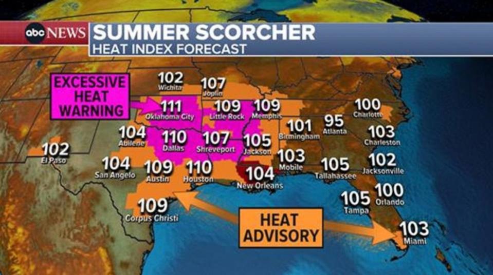
New Orleans is under an excessive heat watch for Sunday where heat indices could reach up to 113.
Excessive Heat Watches and Warnings are in effect up and down interior California as temperatures soar to the triple digits for days.
Meanwhile in the South, the heat comes along with an additional factor that the west doesn't often deal with: stifling humidity. The Heat Index will be topping 100° in dozens of cities across the south this weekend and into next week.
Tropical Update
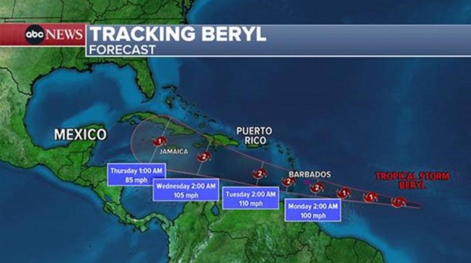
Hurricane Beryl has been rapidly strengthening in the central Atlantic, and is now the first hurricane of the 2024 Hurricane Season.
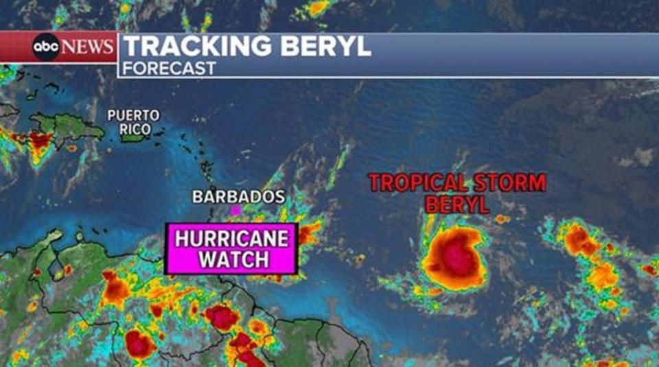
Beryl is forecast to continue to strengthen as the storm heads west towards the Windward Islands of the Caribbean. A Hurricane Warning has been issued for Barbados, with St. Lucia, Saint Vincent and the Grenadines, and Grenada keeping their Hurricane Watch.
The storm is expected to reach the Windward Islands and Southern Leeward late Sunday night or Monday as a hurricane, possibly reaching major hurricane status of Category 3 or higher. This includes the islands of Barbados, St. Vincent, St. Lucia, and surrounding islands.
The National Hurricane Center says that Beryl is forecast to bring "destructive hurricane-force winds and life-threatening storm surge" to the Windward Islands.
After passing through the Lesser Antilles, Beryl is on track to head into the Caribbean Sea and make a run in the direction of Jamaica by the middle of the week.
There is another possible development behind Beryl in the coming week, as well as an area to watch in the western Gulf where Alberto was located.
Northeast under risk of damaging wind, flooding and tornadoes originally appeared on abcnews.go.com

