
Hurricane Sandy, ten years later: how a tragedy improved your forecasts
Hurricane Sandy was a storm for the ages.
The enormous system was part hurricane and part nor'easter when it made landfall in New Jersey on October 29, 2012. Measuring more than 1,500 kilometers across, Sandy stretched from South Carolina to Maine as it roared into the U.S. East Coast.
Sandy remains one of the costliest storms in American history. More than 150 people died in the system’s winds and destructive storm surge that inundated communities near the shore.
Millions of homes lost power at the height of the storm, and the lights stayed out for weeks in the hardest-hit areas. Heavy rains and high winds even reached into Ontario and Quebec.
DON'T MISS: Climate change has altered where tropical cyclones occur, study says
A tremendous storm surge pushed seawater deep into the coast. New York City’s streets and subway tunnels became rivers. The surge and waves destroyed swaths of Atlantic City’s famed boardwalk. Homes crumbled into the ocean—some debris from New Jersey reportedly washed aground in France years later.
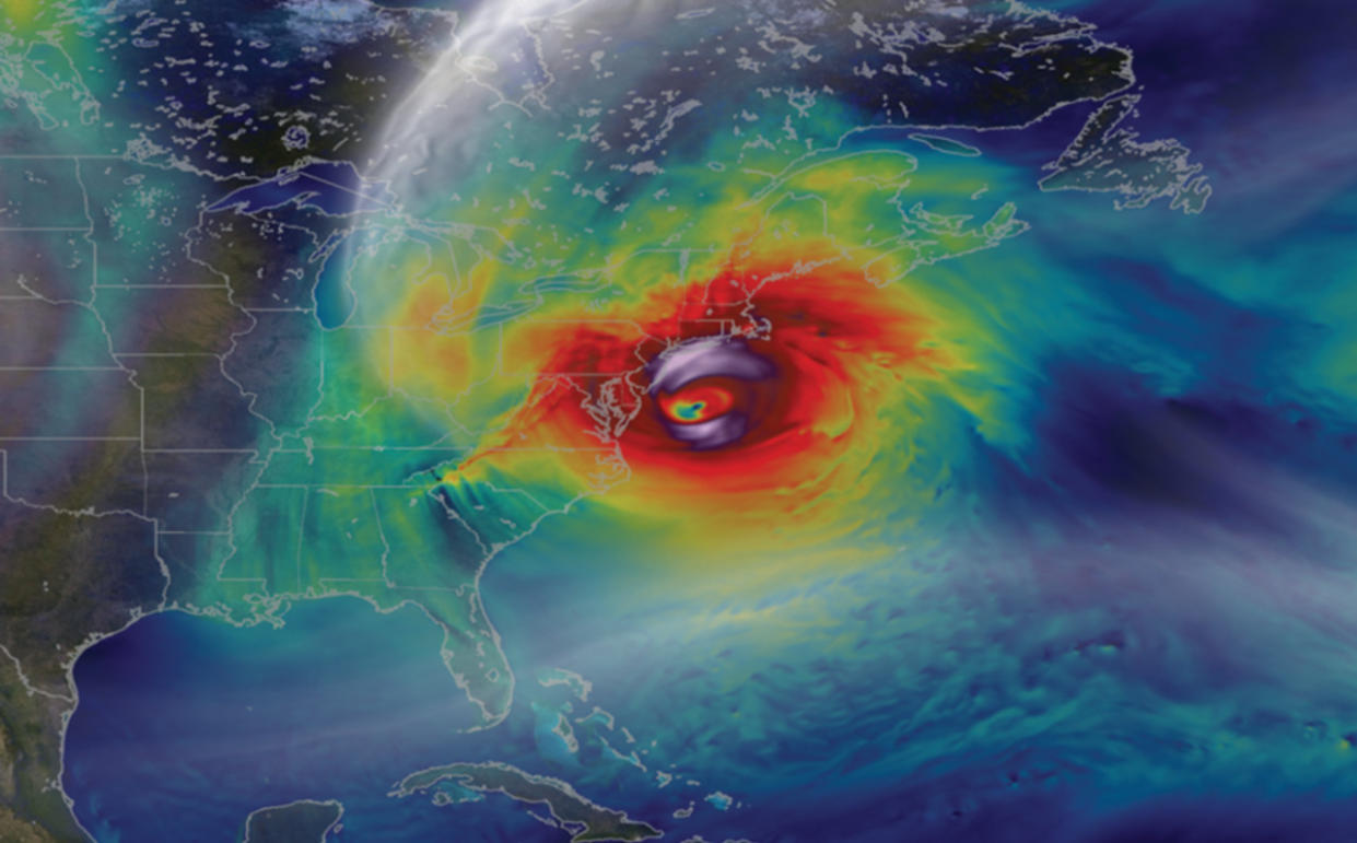
Hurricane Sandy's large and expanding wind field engulfed the U.S. East Coast as it approached landfall on October 29, 2012. (NASA's Goddard Space Flight Center, Scientific Visualization Studio)
The storm grew into a monster because of its transition from hurricane to hybrid. An upper-level trough grabbed the storm and pulled it into the coast like a magnet, forcing a transition that turned the storm into something more like a supercharged nor’easter. This transition dramatically expanded the storm’s wind field, compounding its tragic effects.
Hurricane Sandy’s immense size and the complexity of its forecast made warning folks in harm's way a particular challenge. Thankfully, lessons learned after that fateful storm have helped to improve our weather forecasts in the decade since Sandy made landfall.
PODCAST: Hurricane Sandy strikes New York and New Jersey
WATCH: Why do storms turn 'post-tropical'?
An unprecedented storm required unprecedented rule changes
Any hurricane threatening such a heavily populated area would challenge even the most experienced weather forecaster. But a storm as complex as Sandy broke all the rules—it was such an anomaly that the U.S. National Weather Service’s (NWS) own guidelines prevented the agency from issuing cohesive warnings to alert residents of what was to come.
The biggest hurdle was Sandy’s expected transition from a hurricane to a nor’easter. Back in 2012, the NWS’s guidelines prevented forecasters from issuing tropical storm or hurricane warnings for any system that wasn’t a tropical storm or hurricane at landfall.
Full disk image from NOAA’s GOES-13 with Hurricane Sandy tracking along the southern U.S. coast taken at 9:02 am EDT on October 28, 2012. (NOAA)
MUST SEE: Hurricanes in the North Atlantic are increasing in frequency, says study
Since Sandy wasn’t technically a hurricane at landfall, folks in places like New Jersey and New York didn’t have hurricane warnings ahead of the storm, receiving “high wind warnings” instead. The lack of a direct hurricane warning where Sandy made landfall proved downright confusing for folks in the path of the storm.
As a result, the NHC developed the classification “post-tropical cyclone” to talk about a tropical storm or hurricane that is still a threat, but no longer meets the scientific definition of a tropical system.
This post-tropical cyclone designation allows forecasters to continue issuing warnings and updates on a storm that’s lost its tropical characteristics, but still packs the dangerous punch of a full-fledged hurricane.
RELATED: How hot water fuels the world’s most powerful hurricanes
Folks across the Maritimes directly benefited from this change in 2022 when Hurricane Fiona slammed into the region. Fiona transitioned into a powerful post-tropical cyclone very similar to the way Sandy did ten years earlier.
This time, though, the Canadian Hurricane Centre’s widespread hurricane warnings alerted Maritime residents to Fiona’s impending dangers, and these straightforward forecasts helped folks across the region prepare for the storm’s lashing.
WATCH: The largest Atlantic hurricane on record, Sandy caused billions of dollars in damage
Better messaging around a storm’s impacts
A storm is more than a point on a map.
Most hurricane forecast maps show a hurricane as a single point surrounded by a cone of uncertainty. This can lead to the misconception that only the areas near that point—the centre of the storm—need to worry about dangerous conditions.
That couldn’t be farther from the truth, and Hurricane Sandy proved it in spades. Sandy’s damaging winds, storm surge, and flooding rains stretched hundreds of kilometres from the centre of the storm.
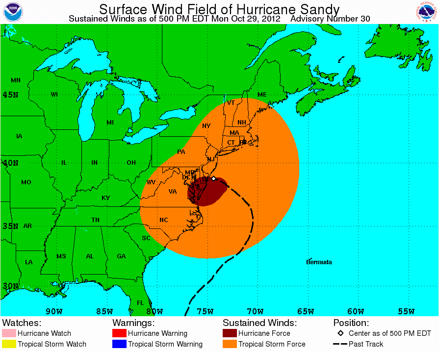
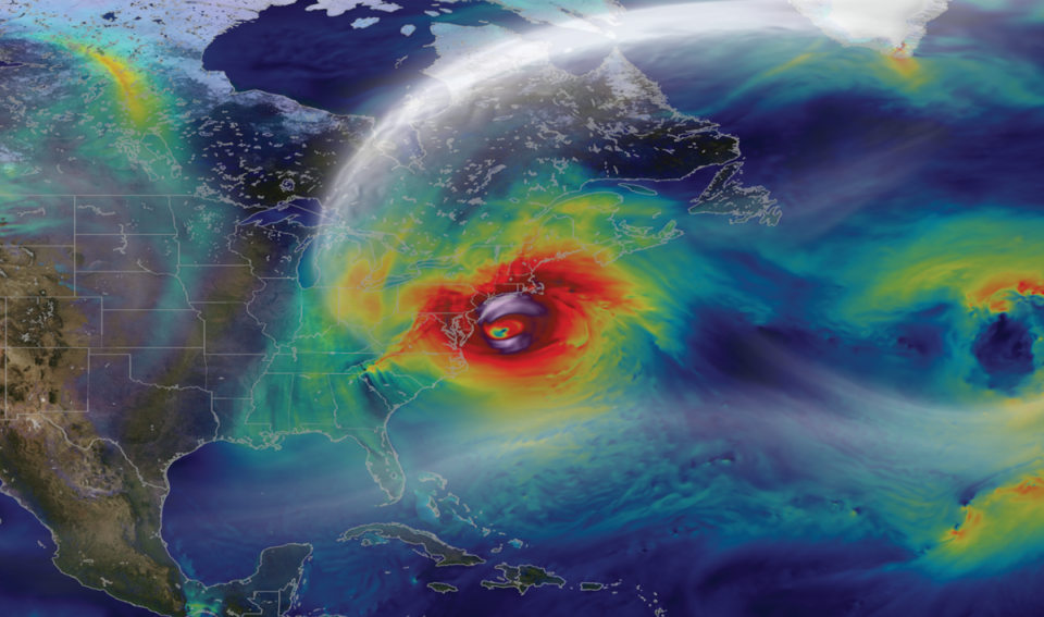
Hurricane Sandy's winds reached hundreds of kilometres away from the very centre of the storm. Focusing on just the eye of the storm, one would miss the true reach of the storm's hazards. (NOAA/NHC)
While that storm ten years ago was unusually large, most tropical storms and hurricanes have an extended reach. Even though the most intense conditions are usually confined to a storm’s eyewall, hazardous weather stretches far away from its centre.
One of the major lessons meteorologists and residents alike learned in Sandy’s aftermath is to focus less on the precise track of the centre of the storm and put more emphasis on a storm’s overall impacts as the system pushes ashore.
We have new tools to predict and monitor tropical systems
Government agencies poured a ton of money into weather modeling in the years after Hurricane Sandy roared ashore. A bevy of new and upgraded supercomputers over the past decade have helped to improve the resolution and accuracy of weather models, providing meteorologists with better guidance to help them craft their forecasts.
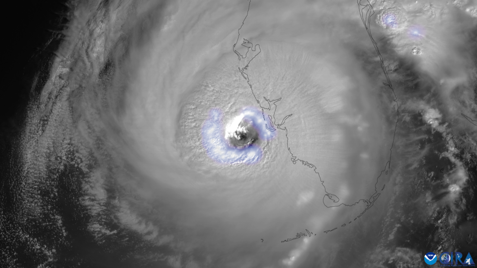
GOES-East captured vivid lightning in Hurricane Ian's eyewall as the storm approached landfall in Florida on September 28, 2022. (CIRA/CSU & NOAA)
We’re also in a golden age of weather satellites. The new suite of satellites watching our skies today provides us with a priceless view of storms as they develop.
These upgraded satellites can take high-resolution imagery of storms as fast as every 30 seconds, giving us a real-time view of storms and features within the storm that can reveal clues about its structure and intensity.
Forecast accuracy has improved over the past decade
Thanks in large part to both improved weather models and greater knowledge and understanding on the part of meteorologists, hurricane track forecasts have greatly improved over the past ten years.
Back in 2012, the NHC’s 24-hour forecast for the centre of a storm was off by an average of 109 km. That average forecast error steadily grew to 267 km by 72 hours and about 443 km by 120 hours, or five days out.
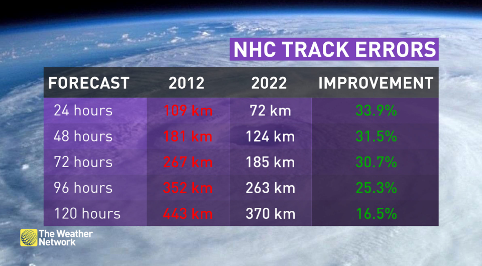
By 2022, the NHC had reduced their 24-hour track errors by one-third, reducing the average error to just 72 km. The average error for a storm’s predicted position five days out came down by 16.5 percent. This results in a much smaller cone of uncertainty today than we saw a decade ago, reflecting a noticeable—and lifesaving—improvement in track forecasts for storms today.
Thumbnail courtesy of NASA's Goddard Space Flight Center, Scientific Visualization Studio

