
Inbound storm brings Quebec multitude of spring and winter hazards

Just like Ontario, Quebec will be at the mercy of Mother Nature this week, throwing a myriad of winter and spring weather hazards at the province.
Everything from potent wind gusts, warmth and thunderstorms, to snow and a flash freeze, are possible Tuesday and Wednesday.
DON’T MISS: Earth just experienced its hottest 12 months in recorded history
Travellers wanting to drive Wednesday afternoon, evening and overnight should brace for difficult road conditions from a sudden and sharp temperature drop, along with icy and snowy conditions. It goes to show Quebecers that winter is very much still in play.
With the strong winds comes a chance of localized power outages, so make sure the devices are charged.
Tuesday and Wednesday will see quick transitions of spring and winter weather
We will begin to see impacts of a low-pressure system on Tuesday afternoon, with scattered rain, freezing rain, and flurries to western Quebec. Roads will be slick during that time, so brace for travelling impacts.
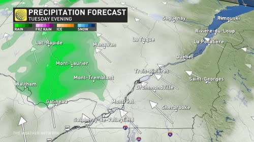
As time progresses, there will be a risk of isolated showers in southern areas. A rumble of thunder can't be ruled out late Tuesday for areas from Gatineau to Montreal.

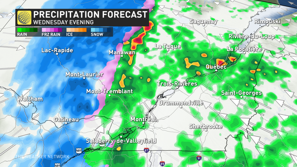
Then, come Wednesday morning, numerous rounds of showers and even some embedded thunderstorms are possible for southern Quebec, with a secondary shot to follow in the afternoon.
The second round will be one to watch for motorists.
A quick switchover to accumulating snow for western Quebec is expected as temperatures will rapidly fall. The same rings true for southern Quebec, but the snow will quickly dissipate. However, the main threat of a flash freeze will linger on.

Temperatures in Mont Laurier and Gatineau will drop down 10-15 degrees in just a three- to four-hour period Wednesday afternoon and evening, then occurring in Montreal in the overnight period. With the milder temperatures, rain and snowmelt, it will cause icy conditions across the province as the colder temperatures will quickly freeze everything.
If it does occur, roads will be quite hazardous so consider postponing any plans to do drive from Wednesday afternoon through the overnight period.
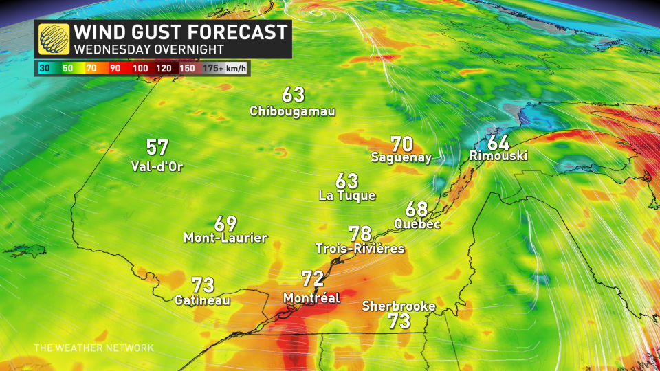
To make matters worse, intense wind gusts are anticipated Wednesday evening and overnight as the front moves through. Gusts of 60-80 km/h will be quite widespread, with some localized areas upwards to 90 km/h. There is the potential for power outages.
The good news is there will be warmer weather by the weekend. An extended stretch of exceptionally mild temperatures will return Friday for southern Quebec by Saturday. Temperatures will soar well above seasonal through this weekend and early next week, with high temperatures more typical of late April and possibly even early May.
Stay tuned to The Weather Network for the latest forecast updates for Quebec.

