
What to know about 4 development sites around Rock Hill and the Catawba River
What do the views of Rock Hill from the Catawba River, woods across from South Pointe High School and property out behind the city operations center have in common? They all could be changing.
Take a look at four of the latest moves proposed for Rock Hill:
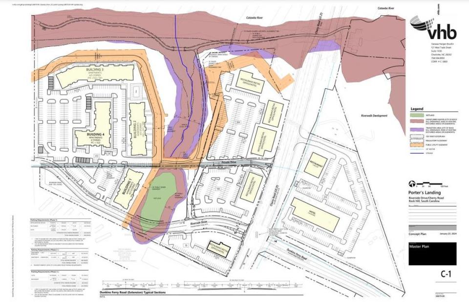
Porter’s Landing
More than 30 acres of Catawba River-front property, where the U.S. 21 bridge comes into Rock Hill, was rezoned in 2016 as Riverside on the Catawba and again in 2019 as Porter’s Landing.
The property allows for 370 apartments, a 130-room hotel and 50,000 square feet of commercial space. Porter’s Landing will replace a house and the former Porter’s motel space. There also were two restaurants there.
Since the 2019 plan approval, Atlanta-based developer WREG sold about 5 acres east of Cherry Road to Riverwalk developer The Greens of Rock Hill. That 2021 sale was for almost $1.7 million.
Now WREG wants changes on the larger portion of Porter’s Landing to the west of Cherry Road. Mixed-use buildings that would’ve had commercial space on the bottom floor with apartments above them, would now be entirely commercial.
That move would drop the residential unit count or Porter’s Landing from 370 to 250 apartments.
An updated concept plan submitted to the city shows five buildings along Cherry, east of a stream that cuts through the center of the property, marked for restaurant, retail, office or hotel use. Four apartment buildings at four or five stories are to the west of the stream, along the western property edge.
Though the Porter’s Landing developer no longer owns it, the property sold to the Riverwalk developer along Dunkins Ferry Road is shown in the concept plan with a hotel and restaurant on it.
The concept plan indicates the build-out of Riverside Drive in alignment with Dunkins Ferry would come first, followed by the commercial portions along Cherry Road. Apartments are listed as a third phase, followed by the hotel and restaurant property to the east of Cherry Road.
Porter’s Landing is between the two bridges that bring traffic from Charlotte or Fort Mill into the city, on Interstate 77 and U.S. 21.
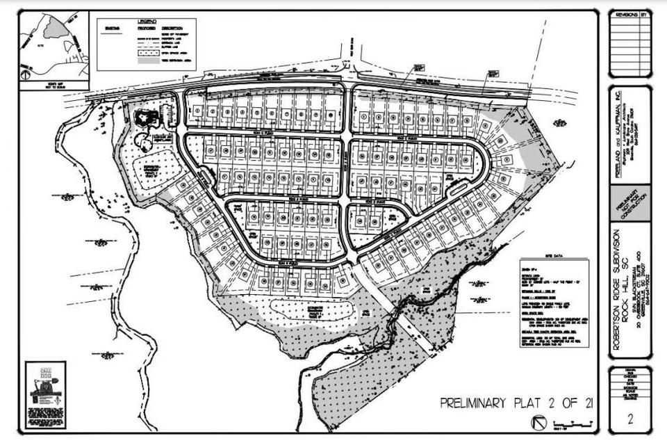
Robertson Ridge
Southpointe Holdings out of Greenville applied to put 90 homes on almost 60 acres at 280 E. Robertson Road. The wooded property sits at the intersection of Robertson and Neely Road, across from South Pointe High School.
Submitted plans show a pool and clubhouse on the west side of the property. There’s also a playground and fire pit, plus pocket parks in other parts of the development.
Plans show two entrances into the new subdivision, one beside the amenity area and the other at the center of the property aligned with Neely Store.
A Rock Hill bus facility
The city owns 76 acres behind its operations center and wants to rezone the site to allow for a bus maintenance facility, warehouse storage and outdoor space for operations materials. A proposed transit station is shown on the concept plan submitted by the city.
The property is on South Anderson Road and Morningstar Drive. The plan includes a new access road between the Hallmark Glen and Ole Townland Estates neighborhoods, off of the Cowan Road Extension that would serve the property.

Flint Street and Porter Road
About 54 acres at the Flint Street Extension and Porter Road are developed as a junkyard and salvage parts business.
Nucycle Land applied for a change so the company wouldn’t have to plant trees in the 50-foot buffer between it and city-owned property because the former landfill site owned by the city is unlikely to develop anytime soon. Nucycle also points to an elevation change in the area that makes buffering in that direction non-useful.
In other directions, there are commercial and industrial businesses, a Flexible Learning Center for the Rock Hill School District and some homes.

