
Category 1 Hurricane Lee updates from the National Hurricane Center for Friday, Sep 15
Article first published: Friday, Sep. 15, 2023, 5 a.m. ET
Article last updated: Friday, Sep. 15, 2023, 8 a.m. ET
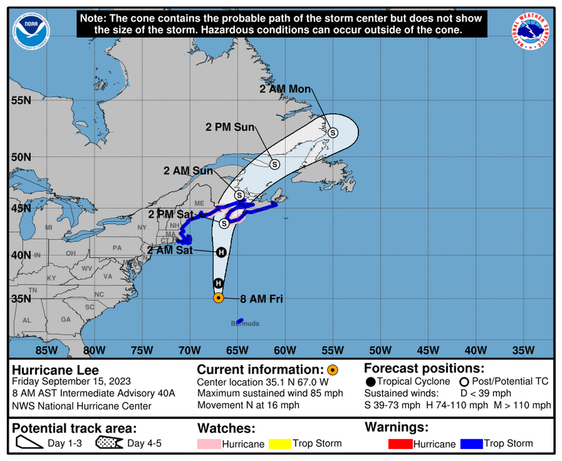
On Friday at 8 am, the National Hurricane Center issued an advisory stating that Category 1 Hurricane Lee is 460 miles south-southeast of Nantucket Massachusetts, with maximum sustained wind of 85 mph. It’s moving 16 mph to the north.
"... the center of Lee will continue to move farther away from Bermuda this morning and approach the coast of New England and Atlantic Canada today and Saturday. Lee is then expected to turn toward the north-northeast and northeast and move across Atlantic Canada Saturday night and Sunday. Little change in strength is expected through tonight." meteorologists observed. "Lee is forecast to become post-tropical and begin weakening by Saturday, but it is still expected to be a large and dangerous storm when it reaches eastern New England and Atlantic Canada."
YESTERDAY (Thursday):
Yesterday, Lee lost strength and was downgraded from a Category 2 hurricane to a Category 1 hurricane with sustained winds of 90 miles per hour.
Portions of atlantic Canada placed under a tropical storm warning by forecasters.
SUMMARY OF WATCHES AND WARNINGS IN EFFECT:
A Hurricane Watch is in effect for:
- Petit Manan Point, Maine to the U.S./Canada border
- New Brunswick from the U.S./Canada border to Point Lepreau, including Grand Manan Island
- Nova Scotia from Digby to Medway Harbour
A Tropical Storm Warning is in effect for:
- Bermuda
- Westport Massachusetts northward to the U.S./Canada border
- Martha's Vineyard
- Nantucket
- New Brunswick from the U.S./Canada border to Fort Lawrence, including Grand Manan Island
- Nova Scotia from Fort Lawrence to Point Tupper
A Hurricane Watch means that hurricane conditions are possible within the watch area. A watch is typically issued 48 hours before the anticipated first occurrence of tropical-storm-force winds,
Conditions that make outside preparations difficult or dangerous.
A Tropical Storm Warning means that tropical storm conditions are expected somewhere within the warning area within 36 hours.
Interests elsewhere in the northeastern United States and Atlantic Canada should monitor the progress of Lee.
For storm information specific to your area in the United States,
HAZARDS AFFECTING LAND:
WIND: Tropical storm conditions will continue on Bermuda through the morning.
Hurricane conditions are possible in the Hurricane Watch areas in Down East Maine and in Atlantic Canada on Saturday. Tropical storm conditions are expected to begin in southern New England late this afternoon and spread northward within the Tropical Storm Warning area through Saturday. Tropical storm conditions are expected to spread across the Tropical Storm Warning area in Atlantic Canada tonight and Saturday. These conditions are likely to lead to downed trees and potential power outages.
SURF: Swells generated by Lee are affecting portions of the Lesser Antilles, the British and U.S. Virgin Islands, Puerto Rico, Hispaniola, the Turks and Caicos Islands, the Bahamas, Bermuda, the east coast of the United States, and Atlantic Canada. These swells are likely to cause life-threatening surf and rip current conditions.
RAINFALL: From tonight through Saturday night, Lee is expected to produce rainfall amounts of 1 to 4 inches, or 25 to 100 millimeters, across portions of eastern New England into portions of New Brunswick and Nova Scotia. This may produce localized urban and small stream flooding.
STORM SURGE: The combination of storm surge and tide will cause normally dry areas near the coast to be flooded by rising waters moving inland from the shoreline. The water could reach the following heights above ground somewhere in the indicated areas if the peak surge occurs at the time of high tide...
Flushing, NY to U.S./Canada border...1-3 ft Long Island Sound...1-3 ft Cape Cod...1-3 ft Martha's Vineyard and Nantucket...1-3 ft Boston Harbor...1-3 ft Rockaway Inlet, NY to Montauk Point, NY...1-2 ft
The deepest water will occur along the immediate coast where the surge will be accompanied by large and destructive waves. Surge-related flooding depends on the relative timing of the surge and the tidal cycle, and can vary greatly over short distances.
A dangerous storm surge will produce coastal flooding within the wind warning areas in Atlantic Canada in areas of onshore winds. Near the coast, the surge will be accompanied by large and destructive waves.
Source: National Hurricane Center
This article was generated by the Sun Herald Bot, artificial intelligence software that analyzes information from the National Hurricane Center and applies it to templates created by journalists in the newsroom. We are experimenting with this and other new ways of providing more useful content to our readers and subscribers. You can report errors or bugs to mcclatchybot@mcclatchy.com. Full hurricane coverage at sunherald.com/news/weather-news/

