
Look up: Swirls, sandstorms, and waves fill our pre-eclipse skies
It’s a solid bet that more people will collectively gaze into the Canadian skies on Monday than we’ve seen in generations as a total solar eclipse dazzles over the eastern half of the country.
Our moon slipping in front of the sun to create several minutes of midday darkness is a once-in-a-lifetime spectacle. For all the millions who have a chance to experience this unforgettable event, even more of us will live vicariously through their lenses.
A total solar eclipse is a rarity for sure, but incredible beauty fills our skies every day. There’s always something to admire if you know where to look.
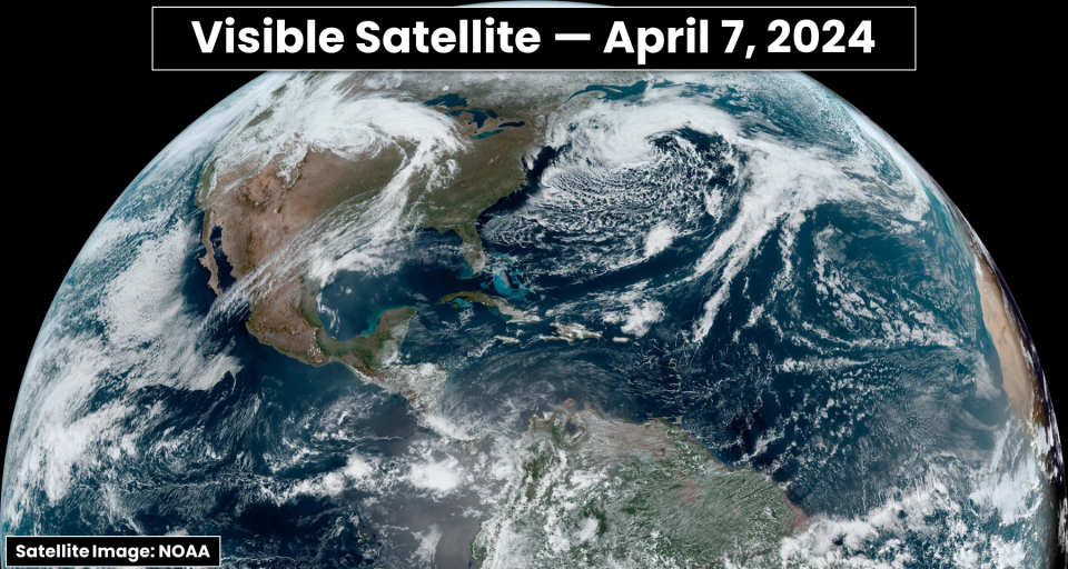
Here’s a look at your world on the day before temporary darkness—a brief glimpse at what swirled, wiggled, and danced above our heads at one moment in time on an average Sunday across the northern hemisphere.
DON'T MISS: From auroras to eclipses, clouds aren’t a stargazing deal breaker
We’re lucky enough to live in a time when high-resolution satellite images are at our fingertips every couple of minutes. It’s a remarkable feat of technology when you stop to consider how far we’ve come in just a few generations.
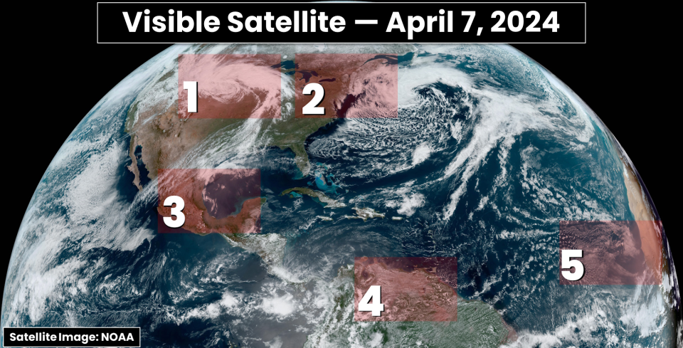
Sunday's satellite imagery doesn’t look like much until you pause and appreciate what’s really going on. A quick glance at this snapshot in time reveals five fascinating features floating effortlessly through the mid-April skies.
1: A pesky storm and a wall of dust
Folks hoping to see the eclipse across the U.S. and parts of Ontario are probably mumbling about the widespread clouds draping over the region.
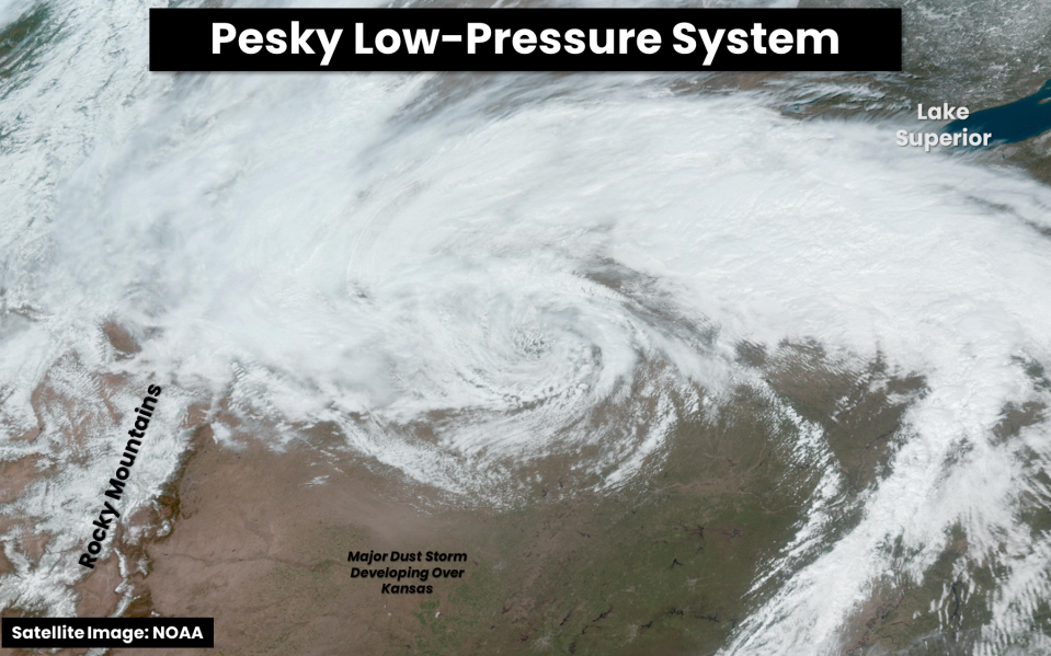
A broad, spiraling low-pressure system churning over the northern Plains is the culprit behind the active weather heading into the beginning of the week. This is one formidable system.
This system forced tremendous winds to roar down the Rockies overnight Saturday into Sunday, leading to widespread damage and power outages along Colorado’s Front Range. A station just east of Boulder measured a wind gust of 153 km/h before dawn on Sunday, and winds of 100+ km/h were common around Denver.
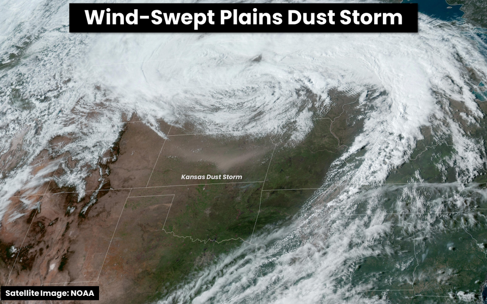
Strong winds continued pulsing over the central Plains through the day Sunday, fuelling multiple wildfires and kicking up a dust storm large enough that it covered a significant portion of the state. The winds, smoke, and dust played a role in numerous car accidents throughout the region.
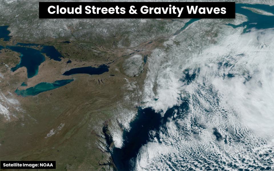
2: Cloud streets and gravity waves abound
If only the crystal clear skies over the Great Lakes stuck around one more day. But the weather does what the weather will, and we got to enjoy blue skies from one horizon to the other a day before they would’ve come in handy.
MUST SEE: Heads up! These six special clouds linger in our skies every day
The severe clear afforded us a fantastic view of where snow continues covering the ground into central Ontario and northern Quebec. Snowpack neatly highlights New York’s Adirondack Mountains.
Beautiful gravity waves appear in the clouds over the New England states as winds undulated after rising up and over the region’s rolling terrain. Cool air blowing over warmer waters led to cloud streets bubbling over the western Atlantic Ocean, making the clouds look like wind-swept steam.
WATCH: How Canadian weather can create extreme winds in Mexico
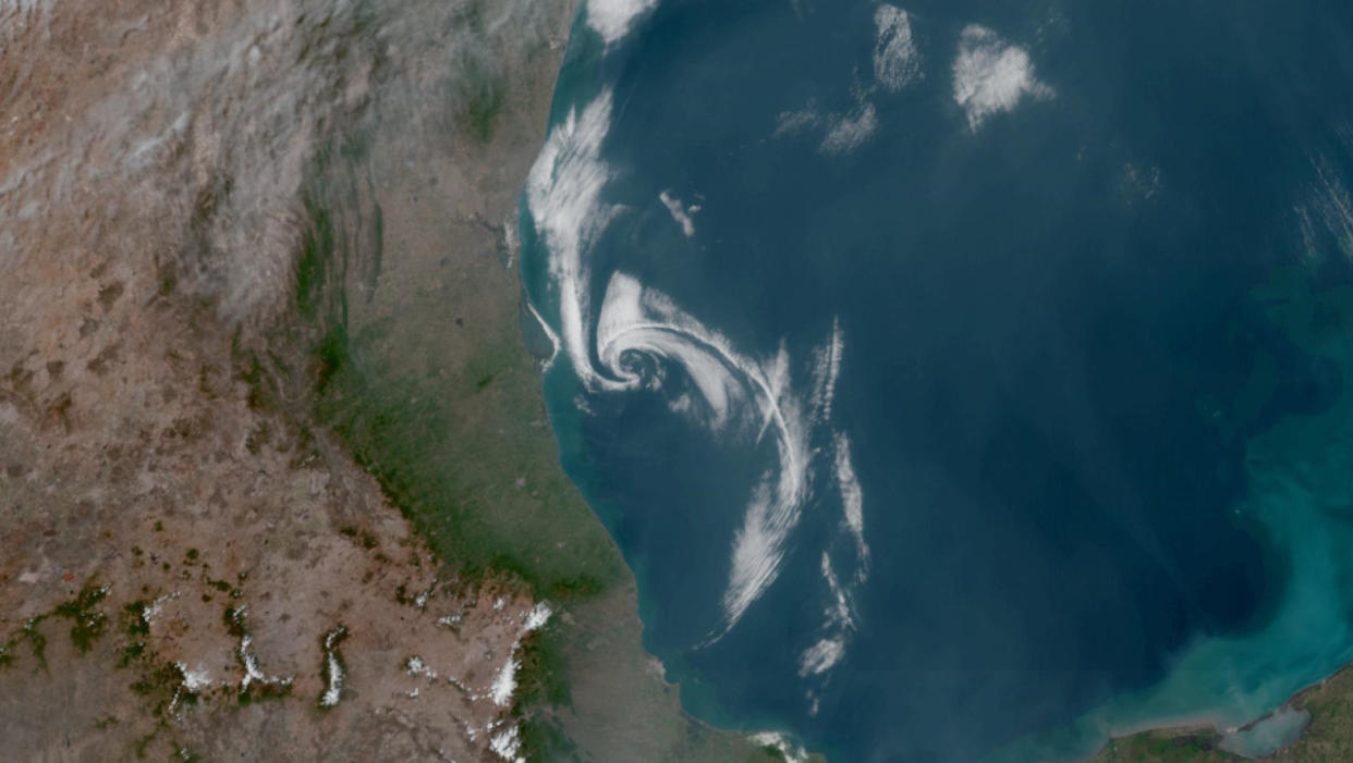
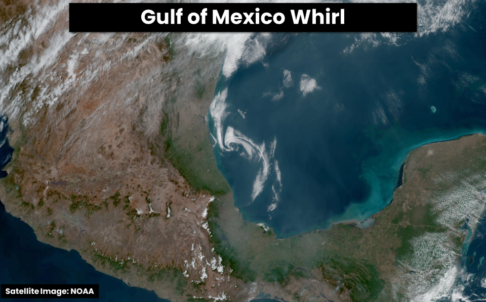
3: A little whirl over the Gulf of Mexico
Giant, swirling lows usually steal all the buzz when it comes to gawking at clouds from space, but the little spirals are often just as interesting.
MUST SEE: Canada’s cold air brings Mexico some of Earth’s most violent winds
A tiny batch of low-level clouds pinwheeled over the southwestern Gulf of Mexico throughout the day Sunday, lingering just a few dozen kilometres off the coast from the resort city of Tampico.
This little feature appeared on visible satellite imagery around sunrise, slowly spinning north before a wind shift forced it to lose some definition and start heading toward land.
Here’s a satellite loop of the miniature low as it spun off the Mexican coast:
Meteorologists often call these features mesoscale lows, or mesolows for short. They’re smaller than everyday low-pressure systems, and they’re often caused by localized processes like winds interacting with mountains or clusters of thunderstorms.
While Sunday’s mesolow off the Mexican coast didn’t cause any harm or foul weather along its path, these interesting swirls can sometimes seed the development of heavy snow, thunderstorms, and even tropical systems during the summer months.
4: Puffy clouds dot the Amazon
The lush and humid Amazon never disappoints when we look at it from above. Puffy cumulus clouds and daily thunderstorms dot this natural wonder year-round due to its tropical latitude and endless stream of plant-supplied moisture.
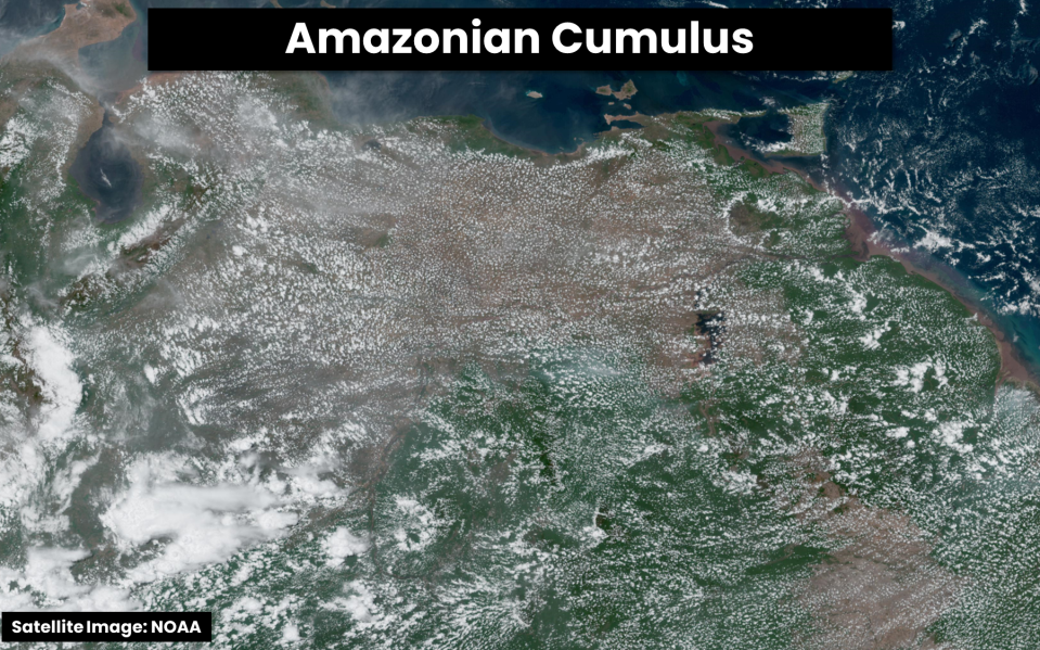
Lake Maracaibo is visible in the top-left portion of the satellite image. Some of the world’s most frequent and vivid lightning illuminates this lake on a nightly basis, with hundreds of thunderstorms filling the skies here throughout the year.
The unique shape of the lake, combined with a vigorous cycle of lake breezes after sunset, give rise to intense thunderstorms on the southern end of the lake near the mouth of the Catatumbo River. The river gave rise to the phenomenon’s common name—Catatumbo Lightning.
5: Dust spirals off the Sahara Desert
We’re just a few months away from watching the skies over the Sahara Desert for signs of tropical activity. Forecasters expect an extremely active Atlantic hurricane season this year, and many of the storms we’ll ultimately track are likely to spawn from thunderstorms rolling off the western coast of Africa.

RELATED: Island churns out dozens of mesmerizing, swirling clouds
Today, though, relatively clear skies give us a stunning view of sand blowing off the desert. Puffs of Saharan dust are a regular occurrence over the Atlantic Ocean, playing a role in everything from suppressing tropical activity to supplying soils and waters with vital nutrients.
The same easterly winds responsible for lofting that dust skyward also created a series of eddies in low-level clouds downwind from the Cabo Verde Islands.
These eddies are called von Kármán vortex streets. They form as winds blow against the higher terrain of an island, oscillating back and forth as the winds converge on the other side.
Von Kármán vortex streets are common in the eastern Pacific, but we can see them in the eastern Atlantic when winds sweep against the Cabo Verde or Azores Islands.
Header image, and all satellite images included in this article, courtesy of NOAA.
Follow Dennis Mersereau on X, the platform formerly known as Twitter.

