
Multiple rounds of storms to end the week in Ontario, Quebec, tornado risk looms
Building instability and a passing cold front will trigger widespread thunderstorms across southern and eastern Ontario, and into Quebec by Thursday. Storms are expected to turn severe for some areas, with the threat for tornadic activity over the Ottawa region on Thursday afternoon.
Large hail and heavy rainfall will also accompany the multiple rounds of storms expected ahead of the August long weekend, so it'll be important to stay weather-aware and heed any warnings issued in your area.
DON'T MISS: Summer’s muggy heat surges and wanes across Canada this August
Wednesday night - Thursday morning
Areas: Southern Ontario
Timing: Wednesday afternoon, evening and overnight
Weather: A moderately moist air mass and day-time heating will trigger isolated, and mainly non-severe thunderstorms across southern Ontario Wednesday afternoon.

With building instability and an approaching cold front, the risk for thunderstorms increases Wednesday night into Thursday morning, becoming even stronger through Thursday afternoon.
DON'T MISS: Watch? Warning? How we communicate severe weather in Canada
Thursday
Areas: Southern and eastern Ontario, and southern Quebec
Timing: Thursday afternoon and evening
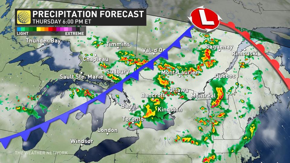
Weather: While the cold front for the most part has been lingering across northern Ontario, bringing thunderstorms there, it will slowly begin to descend across the south and into Quebec through Thursday.
For this week, temperatures are expected to peak in the upper 20s Thursday afternoon, ahead of the cold front's arrival. As such, the risk for thunderstorms will be widespread across southern Ontario and Quebec Thursday, with multiple rounds of storms possible.
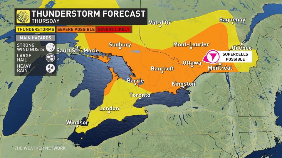
Instability peaks Thursday afternoon and evening, just as the cold front is slicing through, giving the potential for stronger storms that could produce heavy rainfall, small hail and strong wind gusts. The thunderstorm risk will be widespread across all of southern Ontario and Quebec.
The Greater Toronto Area, as well as Hamilton and westward should see mostly heavy rain and small hail.
The areas to watch for severe storms, with tornadic potential, will be near the nation's capital region, and across the river into Gatineau, Wakefield and Clarence-Rockland in Quebec. The signature with these storms will be large hail and heavy rain. The most severe storms in these areas will likely intensify between 4 and 8 p.m.
At last, the cold front will finally sweep through the area Friday, with the last set of storms expected on Friday afternoon, just in time for the start of the August long weekend.
WATCH: Nickel, golf ball, baseball; what these hail sizes mean for damage
Camping this long weekend? Check out The Weather Network's Camping Guide before heading out!
Prepare
Make sure to keep up-to-date on your local forecast information and alerts. If you are outdoors in an area with a severe weather threat, make sure you have a safety plan in place in case you need to get to shelter.
If a severe thunderstorm approaches your location, remain mindful of trees or tree limbs that loom near your home. Trees falling into buildings are a significant source of injury during strong storms. Try to avoid rooms where trees may cause damage during high winds.
The greatest danger in any thunderstorm is lightning. If you can hear thunder, you’re close enough to be struck by lightning.
WATCH: Camping and severe weather, make sure you have a plan
Stay with The Weather Network on all platforms for the latest on conditions across Ontario and Quebec.

