
N.L.'s coastline is on the front line of the climate crisis. Meet some of the people preparing for that
Nobody wants to hear that the street they live on will be underwater in 10 or 20 years, making their beachfront house uninhabitable.
But a sense of humour comes in handy.
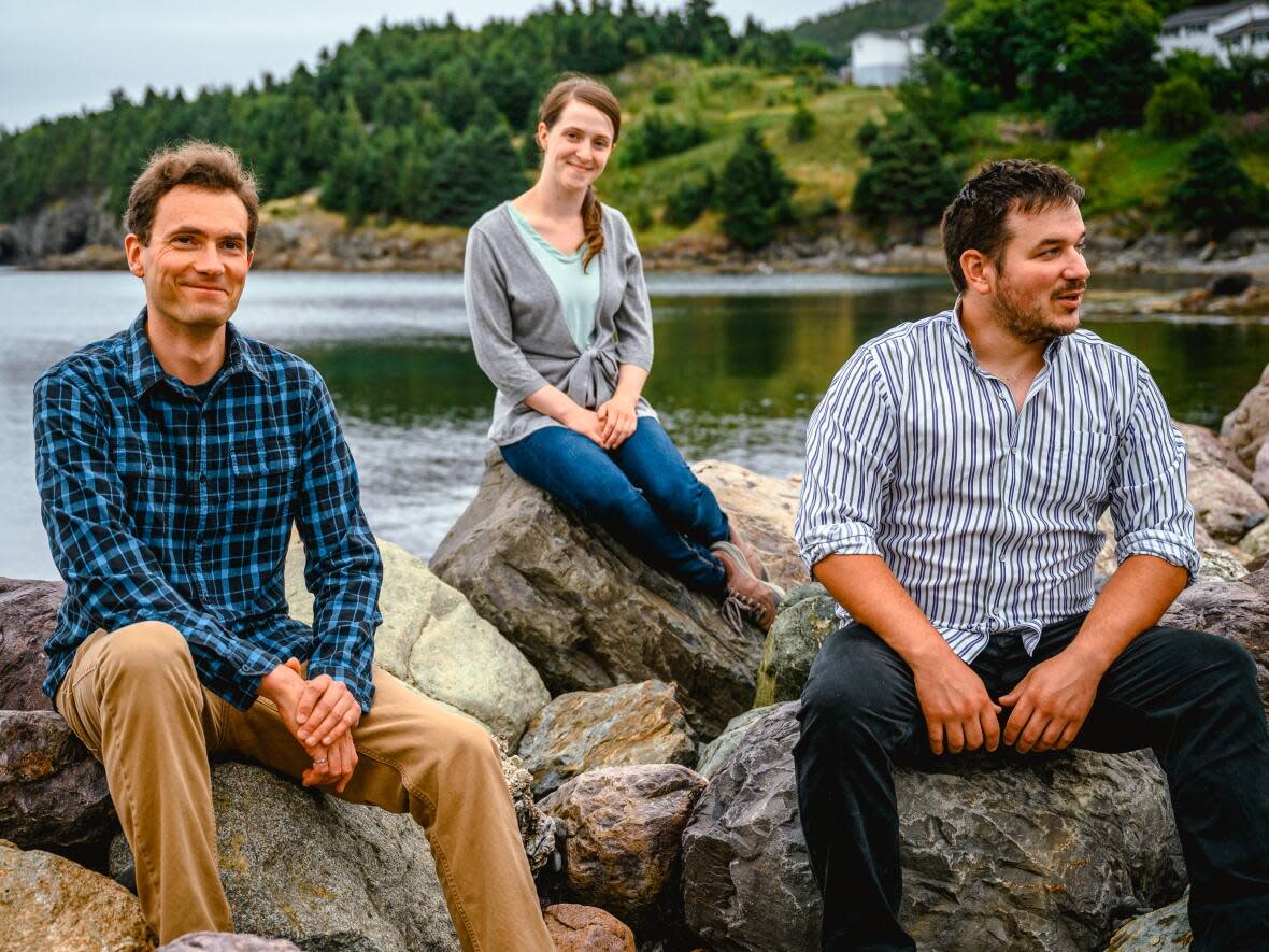
"We've heard comments like, 'I guess I better get my life-jacket ready,'" said Emma Power, a climate change consultant with Fundamental Inc. in St. John's.
Other responses are more emotionally raw, including denial.
"We've had folk that are like, 'that can't be right.' Because you don't want it to be right," said Ashley Smith. "Everybody has had that moment in their life, right?"
"We borrowed a little bit from the medical field. Like when doctors are giving patients bad news, how do they manage that strategy? Because this is people's homes, and their livelihoods."
Smith owns Fundamental Inc. She and Power have worked with over 30 communities across Newfoundland and Labrador, helping them plan for a future that will include rising sea levels, more powerful storm surges, and annual flooding that exceeds anything seen before.
They could have a coastal road that is going to be underwater by 2030, 2040, and it's already washing out. - Emma Power
The science behind those projections is now so precise that it can predict changes at the local level, including every bay and inlet in Newfoundland and Labrador.
The key, says Smith, is to get past the initial shock, and start planning.
"We try to put things in as positive a light as possible. Stay focused on what can be done, instead of getting caught in a negative thought cycle."
When they meet with communities, Power is always on the lookout for the person who takes in the bad news with a nod of recognition.
"They could have a coastal road that is going to be underwater by 2030, 2040, and it's already washing out. So it's no surprise. For them, it's like, 'that explains it.'"
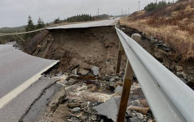
Not much surprises Leon MacIsaac, the town manager in Port aux Basques. He has watched the storm surges get stronger and the winds blow harder since he was a boy.
"Winds, storm surge, and the sea level — it's playing havoc with the coastline."
During the massive storm of November, the most obvious damage was inland, where collapsed roads left the community isolated for several days.
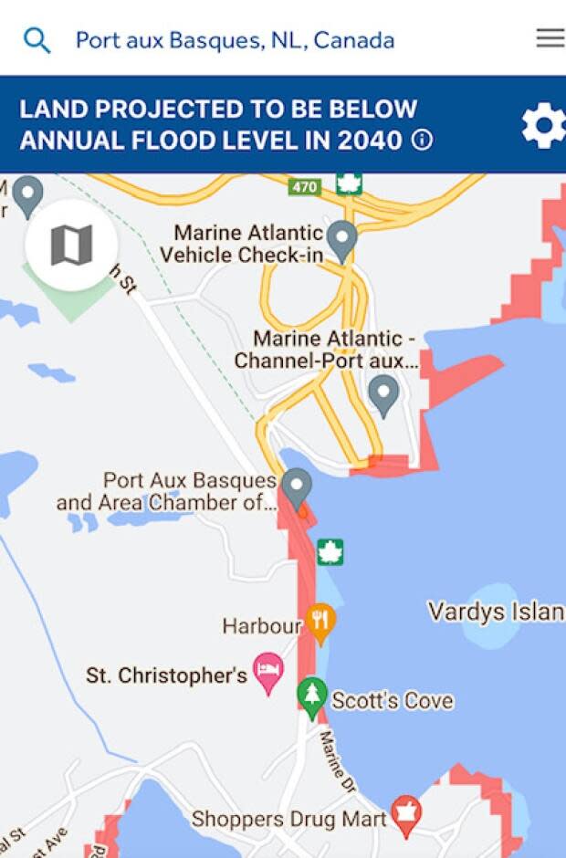
What will rising sea levels and annual flooding look like in your community? Here's an easy way to find out: an easy-to-use map of the future in Newfoundland and Labrador.
You don't have to be an expert to see what the future looks like along the coast of Newfoundland and Labrador.
Anyone can see what sea level rise and annual flooding will look like in the years and decades to come, with the help of user-friendly, interactive maps at Climate Central.
https://www.climatecentral.org/
The tool lets you zoom in for a street-level view of any coastal community, and see how far the waters are expected to go.
"Climate Central references all the latest science from the Intergovernmental Panel on Climate Change," said Emma Power, a climate change researcher and consultant. "It's non-partisan and independent. Their methodology is laid out right in front of you. The transparency is excellent.
"The mandate is to distil all of this information, so it can be understood and then acted upon."
The website has a wide range of maps and other resources
"We usually look at the the sea level rise by year, and that's because it's just very easy to conceptualize that," said Power.
She suggests starting on the "Maps and Tools" page.
https://sealevel.climatecentral.org/maps/
1. From that page, select "Coastal Risk Screening Tool: Map By Year"
2. Enter a community name in the "Search Places" bar and press Enter
3. Choose a map view type in the top right corner (i.e. Satellite)
4. Click "Change Other Settings" on the sidebar to explore options
5. Change the projection year using the slider on the left side bar. For example, by moving the slider, you can see how the expected water levels change with each passing decade.
6. Zoom in and out using the + and – buttons on the right side, or by scrolling with your mouse.
MacIsaac says the damage done to the shoreline doesn't always make for such spectacular headlines. But it's relentless.
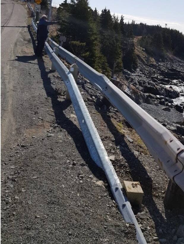
"Port aux Basques has a rocky coast, and it's not unusual to see storms taking huge chunks of rock and throwing them up on properties. Beaches have seen quite a bit of damage, and walking trails. The shoreline is dropping away."
Looking ahead, says MacIsaac, "Our Marine Drive is fairly close to water level. It's going to take some damage. And Marine Atlantic as well, at the dockside level of the harbour."
He won't discount the possibility that some residents or businesses might have to move someday.
"That's part of our future plans, wherever or whenever it might be. You may see a large area eliminated from development because of the proximity to water levels."
Nunatsiavut dealing with rising sea
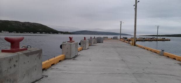
In Makkovik, the town has been building up to escape rising waters.
"We have a breakwater here for small boats," says Barry Andersen, AngajukKak, or mayor, of the community council.
"The high tides in the fall started coming up over the top of the parking lot. We had to go back and revisit it, raise it up a bit more."
The fishermen's wharf needed similar work.
"The fishermen were always complaining that the dock was too low. Their fenders didn't work, their vessels were just banging up against the wharf. So we had it built up by a metre, using concrete blocks around the perimeter of the dock."
As for properties at risk, Andersen knows of at least one: his father's house, just north of town.
"He used to store his qamutiks in front of his house, 10 or 15 feet from the high tide mark. A couple of years ago, he got up in the morning and his qamutiks weren't there. They drifted away on the high tide."
"That same day, his smoke house was like an island. The water rose right up around it."
"He's been here since 1956. It's the highest tides he's ever seen."
Southern shore coastal roads eroding
In Bay Bulls, concerns about the sea level are compounded by the erosion of coastal roads, thanks to the storm waters that overwhelm the drainage system.
"Bay Bulls is like a valley," said town manager Jennifer Aspell. "And we've got a lot of development at higher elevations."
With nowhere to go but downhill, the storm runoff races through the older part of town.
"We've already had to relocate Quay's Road, due to erosion. We're aware of two other areas [at risk] on the north side."
Those problems can only worsen if new developments strip away more green space, which is essential to drainage.
"The idea is for us to be able to anticipate major failures in our system so we can look at it and say, what kind of development regulations do you want? How are you going to impose those? Are you going to move towards net zero runoff?" said Aspell.
"Our job is to communicate, and educate residents. You can see we have a really busy port. We've got a very active fishing industry. We've got world renowned boot tours. All these people will be affected if we have sea level rises, coastal erosion and those types of things."
Power said it's important to take action immediately.
"We don't want to be paralyzed," she said. "We have to get moving on this and accept it, because we don't have many choices."
But in some communities, the stumbling block might be the capacity to take on such a challenge.
Projections for the town of Cupids, for example, show high tides washing over the coastal road within a decade. The results of that study have been distributed to residents and businesses. But Mayor Shari Porter says the town council has a lot on its plate right now.
"A lot of smaller municipalities, they don't have the budget to take on climate initiatives," said Aspell. "Even if they could allocate the money, they don't have the staff with expertise in this area."
"In some ways, a regional approach to climate change may be better as it is a big issue."

