
NASA has its first detailed map of water on the Moon

On one of its final flights, a unique NASA telescope just provided a key discovery that may secure the future of lunar and space exploration.
In February 2022, astronomers used NASA's now-retired SOFIA telescope — the Stratospheric Observatory for Infrared Astronomy — to scan an immense region near the south pole of the Moon. Based on the images collected, they produced a new map that covers over 230,000 square kilometres of the lunar surface, revealing an abundance of water trapped on the shady sides of mountains and in the shadowed parts of craters.
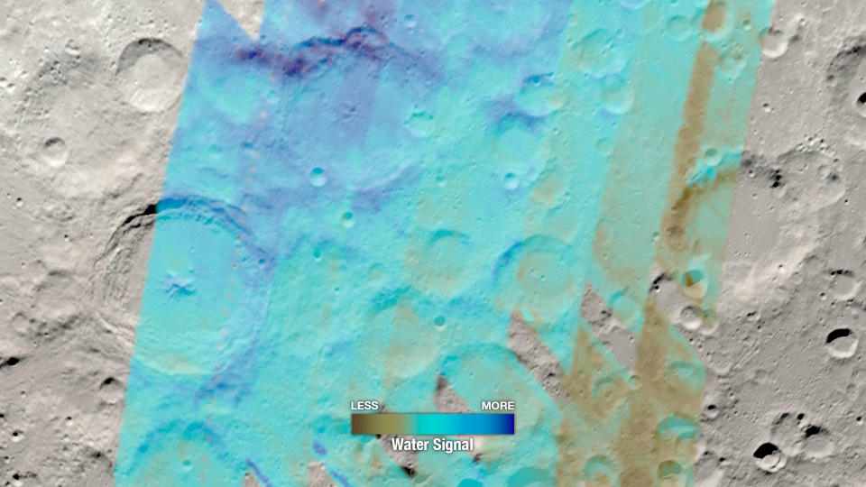
This image shows roughly half of the SOFIA map of water near the lunar south pole. Darker shades of blue indicate the greatest amount of water, while shades of brown note regions with less water. Credit: NASA/GSFC SVS/Ernie Wright
"When looking at the water data, we can actually see crater rims, we see the individual mountains, and we can even see differences between the day and night sides of the mountains, thanks to the higher concentration of water in these places, Bill Reach, director of the SOFIA Science Center at NASA's Ames Research Center, said in a NASA press release.
Reach is the lead author of a new study based on SOFIA's observations, published in mid-March.
The idea that there's water trapped in the perpetually shadowed regions of the Moon is not a new one. Previous studies have revealed hints of what was there, by detecting the presence of hydrogen and oxygen. However, there was no way at that time to determine if we were seeing actual water (H2O) or some other chemical combination of the two elements (such as the less-useful OH 'hydroxyl' molecule).
Observations by SOFIA back in 2020 confirmed the presence of actual water. These new observations reveal exactly where it is, and how much of it is there.

The SOFIA telescope flies on board this jetliner, to get above the thick tropospheric air to take infrared images of objects in space. Credit: NASA
According to NASA, this is only the first of several lunar water maps that will come from these SOFIA observations. More are on the way, as the team focused on several future lunar mission landing sites.
"With this map of SOFIA data, and others to come, we are looking at how water is concentrated under different lunar environmental conditions," said Casey Honniball, a visiting scientist at NASA's Goddard Space Flight Center, who is working on the upcoming VIPER mission to the Moon. "This map will provide valuable information for the Artemis program on potential prospecting areas but also provides regional context for future science missions, like VIPER."
VIRER is NASA's Volatiles Investigating Polar Exploration Rover, a robot that is expected to land at the lunar south pole sometime in 2024. Its target will be Mons Mouton, a mountain located in a region that will be detailed in one of the upcoming maps from SOFIA.
Following VIRER, Artemis III is expected to launch in 2025, with the intention to land astronauts near the Moon's south pole. This will be the first crewed mission to touch down on the lunar surface since Apollo 17 in 1972. If the water discovered by SOFIA and investigated by VIPER is found to be a resource that we can easily extract, Artemis III could quickly become the start of a sustained human presence on the Moon.

