
Late-winter storm barrels across Atlantic Canada with snow, rain and winds

A duo of systems bringing foul weather to Ontario and Quebec gets to its final destination in Atlantic Canada to end the weekend, sticking around as an unwelcome guest to begin the new week.
The system will bring different types of impacts, including blustery winds, heavy rain and yet another a shot of heavy snow through the early part of this week. A wide variation in snowfall totals is expected, depending on locale, but the heaviest is expected portions of New Brunswick and Newfoundland.
DON'T MISS: Everything you need to know for April's spectacular and rare solar eclipse
Rainfall, snowfall and wind warnings, along with special weather statements are plastered across a good portion of Atlantic Canada. Localized flooding in low-lying areas, treacherous travel and power outages are likely impacts from the storm, so plan ahead and expect interruptions.
Sunday: No time for a breather as the next storm arrives
The Maritimes will see a rain, snow or mixing to start the day on Sunday, depending on locale. The South Shore and Halifax area in Nova Scotia will see about 20-40 mm of plain, old rain through the day, while northern portions of the province, including Cape Breton, contend with a wintry mix.

RELATED: Be aware of your heart while shovelling heavy snow
Wet snow to start the day across New Brunswick will likely transition to rain for most of the province as temperatures warm up through the afternoon. Only northwestern parts of New Brunswick will remain in the heavy, wet snowfall.

Across northeastern New Brunswick, very heavy snowfall rates up to 5 cm an hour is expected to peak Sunday evening and overnight.
Monday: System winds down in Maritimes, Newfoundland is next
The heavy, wet snowfall over northern portions of New Brunswick will continue Monday morning while rain persists across much of Nova Scotia, then becoming mixed with snow as the day progresses.
PHOTOS: Messy winter storm blankets parts of Newfoundland
Northern New Brunswick could see 30+cm of snowfall by the time the system draws to a close on Monday. The heavy, wet snow will clog roads and could weigh down trees and power lines, leading to localized power outages across the region.

Gusty winds up to 70 km/h will likely not be overly problematic for the electrical grid, but some power outages are still expected.
Newfoundland will see wet snow spread across central regions of the province on Monday afternoon while those in the Avalon will be spared heavier snowfall amounts for now as they are expected to see a wintry mix during this time due to temperatures hovering just above the freezing mark.
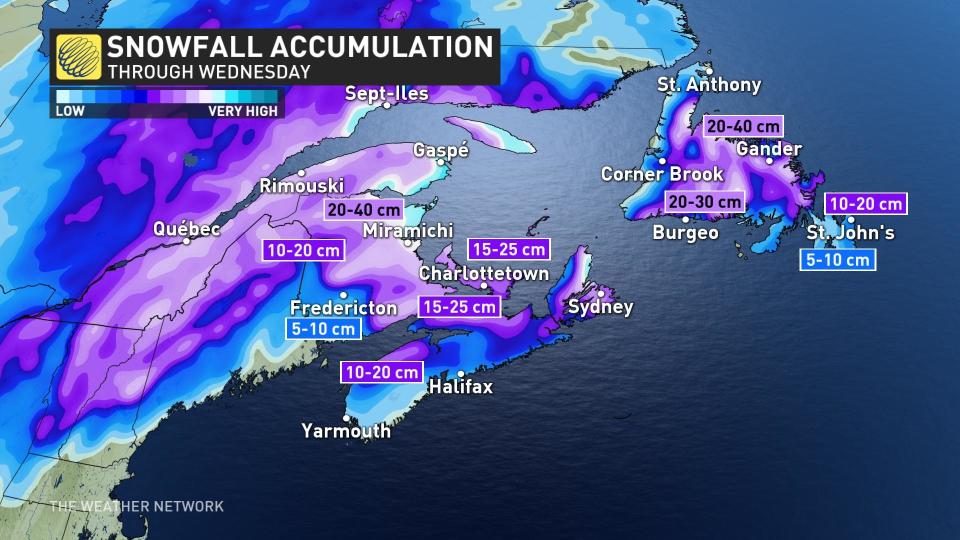
Snowfall totals across Newfoundland will be highly elevation-dependent, with a large range in totals away from the water and across higher terrain –– up to 10-15 cm across higher portions of the eastern Avalon and 15-25 cm of wet snow across areas of central Newfoundland.
If you’re on the Avalon Peninsula, be sure to clear snow away from storm drains so the run-off from rain and snowmelt doesn’t pool up.
Tuesday: Cold air wraps around with more snow chances
Snow will continue in Newfoundland as the low-pressure system lingers over the region for another day. We’ll see more mixing and opportunities for wet snow creeping into the Avalon as the atmosphere cools over the peninsula.
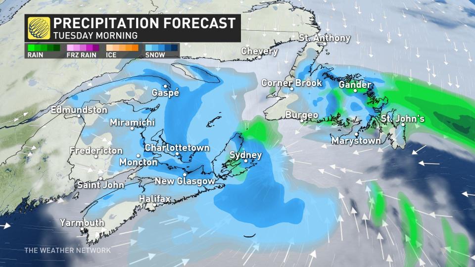
Cold air wrapping around the system will foster periods of snow across the Maritimes on Tuesday. A light coating of snow is possible in some areas, adding up to several centimetres locally.
WATCH: Tips to help your body adjust to the time change this weekend
Be sure to check back for the latest weather updates across Atlantic Canada.

