
Wintry weather holds firm as rounds of heavy snow blanket Atlantic Canada
March will certainly go 'out like lion' across Atlantic Canada, as three separate systems over the next week or so are set to deliver significant snow to the region.
MUST SEE: A trio of storms will showcase what a Canadian spring is all about
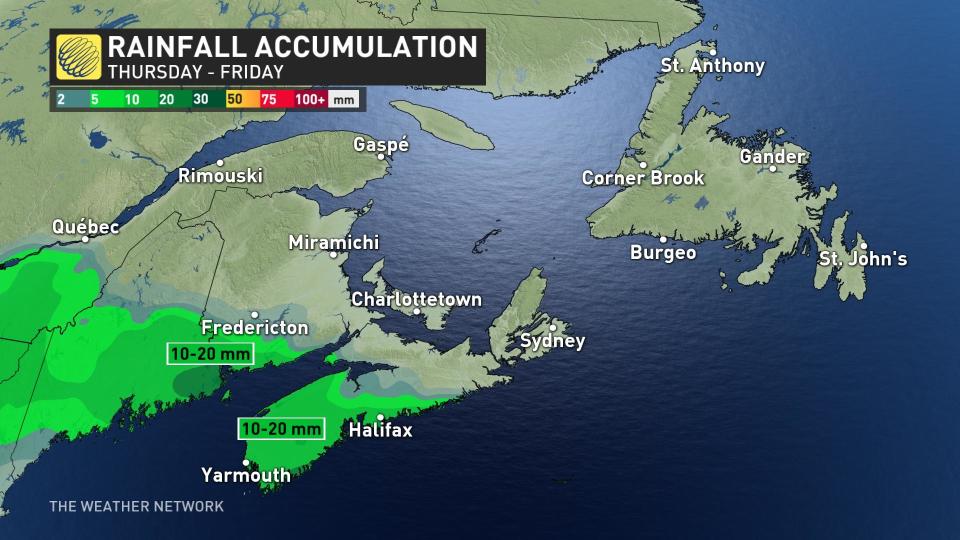
The first threat begins early Thursday morning across western New Brunswick, with snow to start as precipitation spreads east across the province. Nova Scotia will see snow begin during the morning in the west, changing over to rain through the afternoon hours.
The mixing line between rain and snow will extend from the Fundy Shores in New Brunswick into the greater Halifax area. Snow is the primary concern east and north of these regions. All snow is expected across Prince Edward Island, beginning Thursday afternoon and continuing into the day Friday.
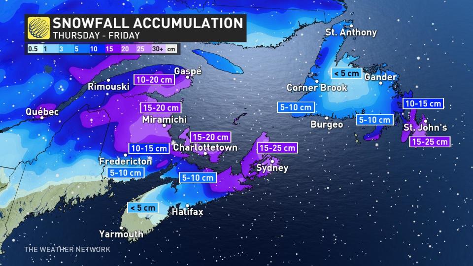
Between 5-15 cm of snow is on tap for central New Brunswick, with 15-20 cm possible in P.E.I. The heaviest swath of snow with this system will fall across northern New Brunswick and eastern Cape Breton, with 15-25 cm expected through Friday.
While there will be some rain, it's not a major concern, with 10-20 mm forecast in southern New Brunswick and the western half of Nova Scotia.
RELATED: Spring flooding in New Brunswick: Don't let your guard down
Snow will reach Newfoundland on Friday as the low tracks south of the island. This southerly track will focus the snow on the Avalon Peninsula, where accumulations could reach 15-25 cm by Saturday. Forecasters expect 5-15 cm of snow for central and western Newfoundland, with 10-15 cm falling on the Bonavista Peninsula.
Special weather statements are already in effect for the province.
Drivers are being urged to plan accordingly as a slight shift in the storm track could have a huge impact on precipitation types over the island. Gusty northeasterly winds between 70 to 80 km/h could also result in blowing snow and reduced visibilities in periods of heavy snow Friday night and Saturday.

The next system will begin pushing into the Maritimes just as the snow winds down on Newfoundland on Saturday night. This second system will bring primarily snow to the Maritimes Sunday into Monday.
The final few days of March will bring widespread snow as yet another strong low-pressure system tracks through the region.

Be sure to check back for the latest forecast updates across Atlantic Canada.

