
Surprising warmth will continue to keep Ontario toasty as October starts
It’s the middle of fall and the beginning of October, but next week will feel like a flashback to the middle of summer across much of Ontario.
A formidable ridge of high pressure building over the Great Lakes in the days ahead will send daytime highs soaring into the mid-20s across southern Ontario, which is quite unseasonable for this time of year.
But warm-weather lovers should enjoy it while it lasts—the pattern may flip soon enough.
Visit our Complete Guide to Fall 2023 for an in-depth look at the Fall Forecast, tips to plan for it and much more!
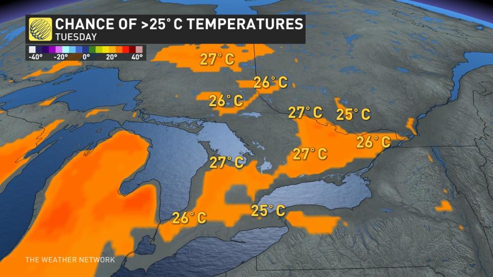
Building ridge builds summer-like heat
The ridge of high pressure building over the Great Lakes will allow warm temperatures to lock across southern Ontario as we head into the first week of October.

DON’T MISS: Perseverance spotted an immense 2 kilometre-high dust devil on Mars
Meteorologists call the upper-level pattern over Eastern Canada an ‘Omega block’ because of its uncanny resemblance to the Greek letter Omega. This kind of setup leads to a resilient ridge that’s tough to dislodge, allowing unseasonable warmth to stick around for days on end.
We’re likely going to see daily temperature records fall in spots across the province, but all-time October heat records seem out-of-reach even from this bout of unseasonable heat.
Hamilton, for instance, saw a 32.2°C reading back in October 1951—a high-mercury mark that’ll remain safe through this warmup.
We will have to watch the duration of the warm temperatures, though, as the intensity of the heat won’t be quite as remarkable as just how long it may stick around. Usually, this kind of warmth in October only lasts for a day or two as a passing storm pulls in warm winds from the south.
MUST SEE: How a U.S. government shutdown may affect weather and disaster prep
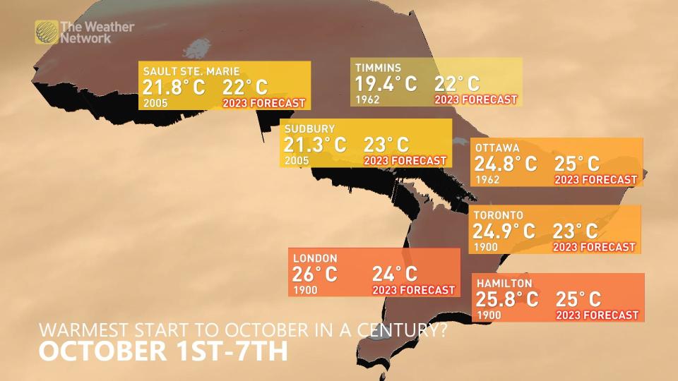
Current models are suggesting that the average daytime highs over the first week of October could be the warmest in 100 years for several cities, including Ottawa, Sudbury, and Timmins.
Fall is a season of rapid change, of course, and this callback to summer days will eventually end as we head toward next weekend. There is some uncertainty in exactly when the warmth will come to an end, and how quickly we’ll cool down afterwards.
Long-range models show the arrival of a couple of cold fronts by Thursday and beyond, with more seasonable air arriving by the latter half of next weekend.
Stick with The Weather Network in the days ahead to find out what the rest of October has to offer when we release our October outlook on Sunday.
WATCH: Heavy rain triggers major flash flooding in New York City on Friday
Thumbnail courtesy of Getty Images.

