
Ontario faces a potent weekend storm, but exact details still uncertain

Our attention is on a potential, high-impact storm that targets the Great Lakes this weekend. This will be one to watch as it could pack a lot of hazardous weather.
WINTER 2024: El Niño will play a critical role in the weeks ahead
Much of the exact track and impacts are still uncertain, but widespread, windy conditions are expected, along with rain and very mild temperatures, even reaching into the double digits for some.
However, before we dive a bit deeper into that, there is a quick disturbance that will move through Wednesday night to Thursday morning. What Ontarians can expect from the first system, and then what could transpire with the weekend storm, below.
Wednesday night into Thursday morning
A disturbance will track from northwestern to southern Ontario, bringing some snow to the region.
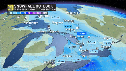
A quick 2-5 cm of snow is possible along the track, with areas away from the centre of the track seeing less than 3 cm. The disturbance does have the potential for some areas to overachieve, potentially bringing some areas near Georgian Bay and central Ontario above 5 cm.
The snowfall will make for slick roads, so be prepared for tricky travelling during this time.
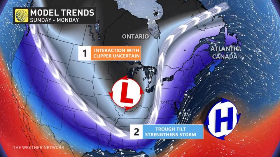
Sunday into Monday: Rain, wind and snow. This storm could have it all
Ingredients are coming together for a windy December storm, with impacts felt through much of Ontario Sunday and Monday. A Texas low will slingshot an abundance of Gulf moisture northwards, allowing for heavy precipitation rates to fall. Precipitation types of rain or snow will highly depend on the storm’s track, which still has uncertainty at this point.
RELATED: How Colorado lows and Texas lows affect our weather in Canada
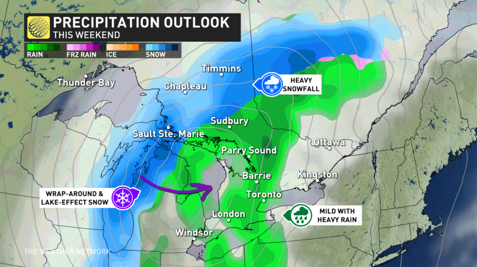
What we know is to the northwest of the storm's path, heavy snowfall is expected for areas in central and northern Ontario. To the east, very mild air and rain are expected for southern Ontario -- at least at first.
Once the system moves through, wraparound and lake-effect snow will likely set up in behind, flipping the switch from a fall-like storm to more of a wintry one for Monday.
Precipitation won't be the only weather element, either, as we'll have to monitor for gusty winds. With the uncertain track of the system, the transition from mild to cold air could be faster and could also be a bit farther south.
Current guidance places the storm over one of the Great Lakes, strengthening on its way. This generates widespread, gusty winds, which may prove dangerous when paired with heavy snowfall.
With gusts easily over 50-60 km/h likely, whiteouts are expected where the snow sets up. Those at risk are on the northwest side of the storm, and parts of southern Ontario with the wraparound flurries.

Going somewhere? Check out the current highway conditions before heading out!
Forecasters will keep a close watch on where the storm track sets up over the next few days. Until then, plan ahead, and brace for some slow travel Sunday into Monday.
Milder pattern ahead of Christmas likely
A few days of colder weather, and lake-effect flurries, are expected for the middle of next week before temperatures rebound again late next week and into the following week, as well.
While the temperature roller-coaster looks to continue into the weeks to come, at this point, it looks relatively mild during the week leading up to Christmas.
Be sure to check back for all of the latest weather updates across Ontario.

