
Snow creates travel problems in Ontario, next storm on the horizon
A Colorado low and its various precipitation types, including rain, ice and snow, are expected to linger in southern Ontario into Tuesday. Luckily, the ice impact will not be nearly as great or widespread as last week’s winter storm.
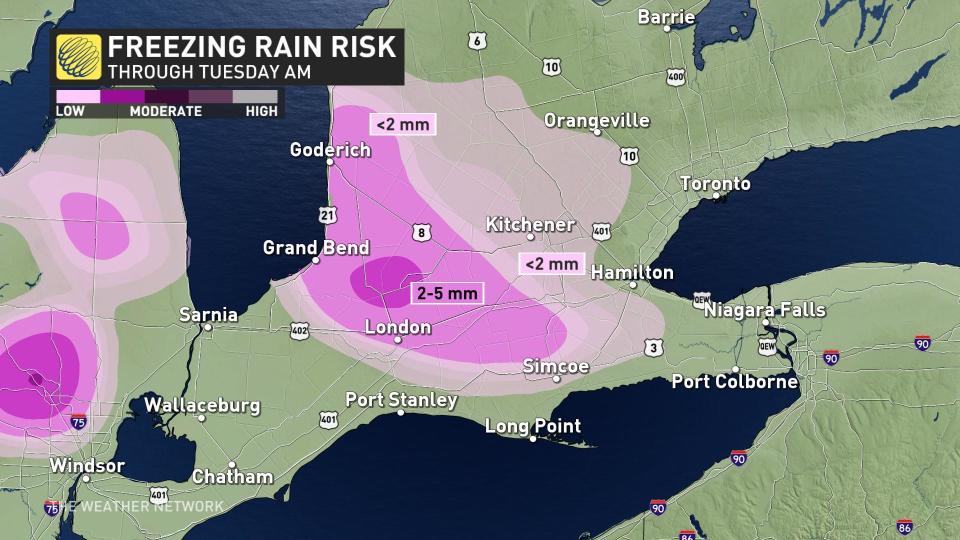
The rain to ice pellets and freezing rain transition took place Monday afternoon along the Highway 402 corridor and up towards the Goderich area. This wintry mix is expected to persist until strong, southwesterly winds surge in a warmer and rainier air mass over the region.

Environment and Climate Change Canada (ECCC) issued freezing rain warnings across southwestern Ontario, expecting between 2-5 mm of ice accretion before it tapers off Monday overnight.
ALSO READ: Icy storm pelts Ontario, causing travel disruptions and multiple power outages
The Greater Toronto Area (GTA) saw precipitation start off as snow Monday evening, leading to significant impacts on the evening commute across the region. Bursts of heavy snow and gusty winds of 50-70 km/h reduced visibility on many roadways including the 400-series highways.
Bad visibility in downtown, slippery streets, wind and lots of flowing snow, according to sources 8cm are expected, stay safe #Toronto@ECCCWeatherON #ONStorm #snowstorm pic.twitter.com/HBgLUSfXgE
Bad visibility in downtown, slippery streets, wind and lots of flowing snow, according to sources 8cm are expected, stay safe Mad Jury on Twitter: "Bad visibility in downtown, slippery streets, wind and lots of flowing snow, according to sources 8cm are expected, stay safe #Toronto@ECCCWeatherON #ONStorm #snowstorm pic.twitter.com/HBgLUSfXgE / Twitter"Mad Jury on Twitter: "Bad visibility in downtown, slippery streets, wind and lots of flowing snow, according to sources 8cm are expected, stay safe #Toronto@ECCCWeatherON #ONStorm #snowstorm pic.twitter.com/HBgLUSfXgE / Twitter" Mad Jury on Twitter: "Bad visibility in downtown, slippery streets, wind and lots of flowing snow, according to sources 8cm are expected, stay safe #Toronto@ECCCWeatherON #ONStorm #snowstorm pic.twitter.com/HBgLUSfXgE / Twitter" Mad Jury on Twitter: "Bad visibility in downtown, slippery streets, wind and lots of flowing snow, according to sources 8cm are expected, stay safe #Toronto@ECCCWeatherON #ONStorm #snowstorm pic.twitter.com/HBgLUSfXgE / Twitter" Mad Jury on Twitter: "Bad visibility in downtown, slippery streets, wind and lots of flowing snow, according to sources 8cm are expected, stay safe #Toronto@ECCCWeatherON #ONStorm #snowstorm pic.twitter.com/HBgLUSfXgE / Twitter"
5-15 cm total snowfall is forecast across the GTA, with higher amounts expected in higher elevations, away from the lakeshores.
As temperatures rise above freezing overnight Monday, resulting in the falling snow to transition to some patchy freezing rain, roads and walkways will become slippery and hazardous for the Tuesday morning commute.
WATCH: Whiteout conditions hit southern Ontario as roads come to standstill
Similar to the GTA, communities along the eastern shore of Lake Ontario will also see 5-15 cm of snow, with the potential for mixed precipitation to make for even messier conditions.
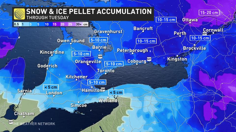
While eastern Ontario will not have to worry about mixed precipitation making a mess of things, it will be getting the brunt of the snow with this system. 10-15 cm of snow is expected along the Highway 401 corridor, in eastern Ontario and into the Ottawa area.
Beyond the early-work week, wintry mess, more systems are expected to follow as an active storm track sets up over the Great Lakes. Warm air to the south continues to fight back on Arctic air attempting to descend, spawning a stormy corridor the entire week.
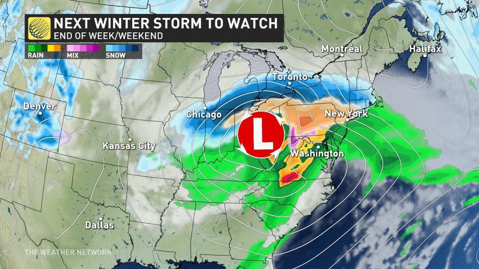
Another messy system with high snowfall totals is expected to eye southern Ontario Friday and into the weekend, so check back with us on the latest forecast for the storm coming late week.
Keep checking back to The Weather Network for more updates and information on your weather in Ontario.

