
Mother Nature flips the switch in Ontario with rain aiding dry spell

A begrudgingly welcome gloom is locked in across Ontario as an upper-level system dawdles over the Great Lakes for the first half of the work week.
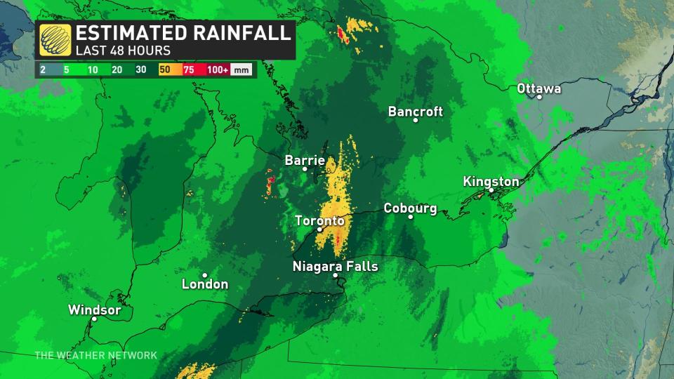
For some areas, this could be the most rain we’ve seen in one dose for several months. Unfortunately, it’ll miss the fires that continue to burn in western Quebec, but the rain will help make a small dent in the abnormally dry conditions that have gripped the region.
DON’T MISS: El Niño is here for the summer—but how strong will it grow?
An upper-level low ended the weekend by swinging across the Great Lakes like something of an atmospheric bowling ball, sparking widespread severe weather south of the border while thick clouds and steady rain developed over Ontario.

This system aloft isn’t in any hurry to clear out of the area, solidifying a spell of unseasonably cool temperatures and rainy weather through the middle of the week.
Storm and flood threat for parts of Ontario
Some areas near the Lake Huron and Lake Ontario shores might see a touch less rain, while spots near North Bay and Sudbury have a chance to exceed 50 mm of rain from this system.
MUST SEE: What parents can do to keep their children safe from wildfire smoke
As a result of the deluge, the Toronto and Region Conservation Authority (TRCA) issued a flood warning Monday for the lower Don River. Its stream gauges on the lower Don River were showing rising water levels at or near the Don Valley Parkway (DVP) and Bayview Avenue extension due to the rainfall.
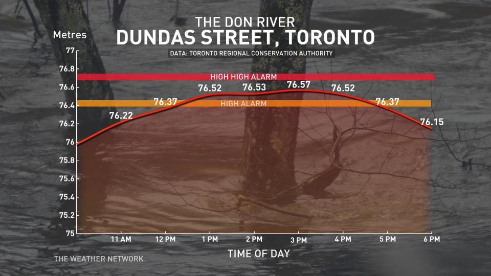
"The water levels are still steadily rising along transportation corridors, specifically the Don Valley Parkway, the Bayview Avenue extension, the GO Richmond Hill Line and other lower lying roadways along the Don River," TRCA said in the alert.
We could be on the cusp of recording Toronto’s wettest day since April 22, when the city measured 23 mm of rain in the gauge. Hefty rainfall totals are expected from Windsor to Timmins and just about everywhere in between, with widespread totals of 30-50 mm on tap through Wednesday.
WATCH: Rivers in southern Ontario risk flooding after heavy rain
Lingering showers, cooler temperatures hang on this week
Our upper-level low will begin to unravel and stall out over Ontario by Tuesday, pulling some rain back toward the Greater Toronto Area like a carousel of precipitation. This shower activity will likely spill into Wednesday, as well.
Temperature-wise, it’s going to feel a little raw for the middle of June for most folks across southern and eastern Ontario. Temperatures will only reach the upper teens in many spots, with the best chance for cracking the 20-degree mark falling along the Toronto-to-Ottawa corridor.
Tuesday’s predicted high of just 18°C in Windsor is about 5 degrees below seasonal for the middle of June. Farther north, away from the influence of our chilly upper-level low, Timmins could easily exceed 20°C on Tuesday afternoon -- the rare summer day that northern Ontario comes in warmer than the south.
Stay with The Weather Network for the latest on conditions across Ontario.

