
PHOTOS: Ontario, Quebec sees multiple days of stormy weather, funnel clouds
A slow-moving low over the Great Lakes has led to a myriad of unsettled weather in parts of southern Ontario and Quebec to start the final week of June.
Multiple rounds of storms have trekked across many areas in Central Canada through Tuesday, affecting commutes and triggering tornado warnings on Monday near the Ontario and Quebec border after funnel clouds were spotted and rotation was indicated on radar.
DON'T MISS: Forecast calls for flexible plans for your long Canada Day weekend
While photos of funnel clouds showed up on social media, there has been no confirmation of any ground contact at this point. Monday saw plenty of reports of hail, torrential rainfall, localized flooding, frequent lightning and tree damage, which may or may not have been related to the wind or funnel clouds.
The same low stirred some foul weather again on Tuesday, bringing heavy rain, strong winds and scary-looking clouds to some areas. Weather advisories were issued as conditions were favourable for funnel cloud development. There have been some reports of funnel clouds on social media, along with tree damage that may or may not be related.
Funnel cloud sighted in Milton, Ont., on Tuesday, June 27. (Kent/Submitted)
As the low continues to move east into Wednesday, with more thunderstorm potential in Quebec, drier conditions will move into southern Ontario. This should be good news for lifting the fire bans in cottage country in time for the long weekend.
While the sunshine chances will present themselves, the wildfire smoke will once again return on Wednesday.
For a look at the visuals of the storms from Monday and Tuesday that are circulating on social media, see below.
Tuesday
And then this at the same time11:55am.. I think there was about 1mins worth of funnel action. Including the small Timelapse just prior to this post. Trying to figure out if this is a true funnel. @weathernetwork #onstorm pic.twitter.com/dcmr4JNoaU
And then this at the same time11:55am.. I think there was about 1mins worth of funnel action. Including the small Timelapse just prior to this post. Trying to figure out if this is a true funnel. KevinJGilbert on Twitter: "And then this at the same time11:55am.. I think there was about 1mins worth of funnel action. Including the small Timelapse just prior to this post. Trying to figure out if this is a true funnel. @weathernetwork #onstorm pic.twitter.com/dcmr4JNoaU / Twitter" KevinJGilbert on Twitter: "And then this at the same time11:55am.. I think there was about 1mins worth of funnel action. Including the small Timelapse just prior to this post. Trying to figure out if this is a true funnel. @weathernetwork #onstorm pic.twitter.com/dcmr4JNoaU / Twitter" KevinJGilbert on Twitter: "And then this at the same time11:55am.. I think there was about 1mins worth of funnel action. Including the small Timelapse just prior to this post. Trying to figure out if this is a true funnel. @weathernetwork #onstorm pic.twitter.com/dcmr4JNoaU / Twitter"
Hope someone's coming to take care of this soon #ONStorm pic.twitter.com/DkZCVR01T4
Hope someone's coming to take care of this soon Important Rodent Infestation on Twitter: "Hope someone's coming to take care of this soon #ONStorm pic.twitter.com/DkZCVR01T4 / Twitter" Important Rodent Infestation on Twitter: "Hope someone's coming to take care of this soon #ONStorm pic.twitter.com/DkZCVR01T4 / Twitter"
— Important Rodent Infestation (@Troll_Hamels) Important Rodent Infestation on Twitter: "Hope someone's coming to take care of this soon #ONStorm pic.twitter.com/DkZCVR01T4 / Twitter"
Storms arriving in Ottawa from the south at 17:35. Heavy thunder and lightning. #onwx #onstorm pic.twitter.com/s57rrctS9X
Storms arriving in Ottawa from the south at 17:35. Heavy thunder and lightning. Jenna Leigh on Twitter: "Storms arriving in Ottawa from the south at 17:35. Heavy thunder and lightning. #onwx #onstorm pic.twitter.com/s57rrctS9X / Twitter" Jenna Leigh on Twitter: "Storms arriving in Ottawa from the south at 17:35. Heavy thunder and lightning. #onwx #onstorm pic.twitter.com/s57rrctS9X / Twitter" Jenna Leigh on Twitter: "Storms arriving in Ottawa from the south at 17:35. Heavy thunder and lightning. #onwx #onstorm pic.twitter.com/s57rrctS9X / Twitter"
— Jenna Leigh (@Jennydelanuit) Jenna Leigh on Twitter: "Storms arriving in Ottawa from the south at 17:35. Heavy thunder and lightning. #onwx #onstorm pic.twitter.com/s57rrctS9X / Twitter"
So this is roughly 5:45pm looking NW towards Cedar Springs/Waterdown on the escarpment. My location is Roseland area Burlington. I'm approximately 80ft off the ground. #onstorm @ECCCWeatherON pic.twitter.com/6sVckQKnkj
So this is roughly 5:45pm looking NW towards Cedar Springs/Waterdown on the escarpment. My location is Roseland area Burlington. I’m approximately 80ft off the ground. KevinJGilbert on Twitter: "So this is roughly 5:45pm looking NW towards Cedar Springs/Waterdown on the escarpment. My location is Roseland area Burlington. I'm approximately 80ft off the ground. #onstorm @ECCCWeatherON pic.twitter.com/6sVckQKnkj / Twitter" KevinJGilbert on Twitter: "So this is roughly 5:45pm looking NW towards Cedar Springs/Waterdown on the escarpment. My location is Roseland area Burlington. I'm approximately 80ft off the ground. #onstorm @ECCCWeatherON pic.twitter.com/6sVckQKnkj / Twitter" KevinJGilbert on Twitter: "So this is roughly 5:45pm looking NW towards Cedar Springs/Waterdown on the escarpment. My location is Roseland area Burlington. I'm approximately 80ft off the ground. #onstorm @ECCCWeatherON pic.twitter.com/6sVckQKnkj / Twitter"
— KevinJGilbert (@kevjgilly) KevinJGilbert on Twitter: "So this is roughly 5:45pm looking NW towards Cedar Springs/Waterdown on the escarpment. My location is Roseland area Burlington. I'm approximately 80ft off the ground. #onstorm @ECCCWeatherON pic.twitter.com/6sVckQKnkj / Twitter"
I hope these images help with identifying any of the possible funnel clouds that came through Hamilton/Waterdown area this evening at dinner hour. #onstorm pic.twitter.com/bAnbTR5YcW
I hope these images help with identifying any of the possible funnel clouds that came through Hamilton/Waterdown area this evening at dinner hour. KevinJGilbert on Twitter: "I hope these images help with identifying any of the possible funnel clouds that came through Hamilton/Waterdown area this evening at dinner hour. #onstorm pic.twitter.com/bAnbTR5YcW / Twitter" KevinJGilbert on Twitter: "I hope these images help with identifying any of the possible funnel clouds that came through Hamilton/Waterdown area this evening at dinner hour. #onstorm pic.twitter.com/bAnbTR5YcW / Twitter"
— KevinJGilbert (@kevjgilly) KevinJGilbert on Twitter: "I hope these images help with identifying any of the possible funnel clouds that came through Hamilton/Waterdown area this evening at dinner hour. #onstorm pic.twitter.com/bAnbTR5YcW / Twitter"
Looking West towards Waterdown 5:20pm. #onstorm pic.twitter.com/fogLGXHZU1
Looking West towards Waterdown 5:20pm. KevinJGilbert on Twitter: "Looking West towards Waterdown 5:20pm. #onstorm pic.twitter.com/fogLGXHZU1 / Twitter" KevinJGilbert on Twitter: "Looking West towards Waterdown 5:20pm. #onstorm pic.twitter.com/fogLGXHZU1 / Twitter"
— KevinJGilbert (@kevjgilly) KevinJGilbert on Twitter: "Looking West towards Waterdown 5:20pm. #onstorm pic.twitter.com/fogLGXHZU1 / Twitter"
Monday
These had to be significant straight line winds that pushed through the lake shore. Damage from Crystal beach all the way to Fort Erie ⛈️🌧️💯 #onstorm #StormHour #lake_erie #4WarnWeather pic.twitter.com/yzt9aMs47h
These had to be significant straight line winds that pushed through the lake shore. Damage from Crystal beach all the way to Fort Erie ⛈️🌧️💯 Denis Kreze on Twitter: "These had to be significant straight line winds that pushed through the lake shore. Damage from Crystal beach all the way to Fort Erie ⛈️🌧️💯 #onstorm #StormHour #lake_erie #4WarnWeather pic.twitter.com/yzt9aMs47h / Twitter" Denis Kreze on Twitter: "These had to be significant straight line winds that pushed through the lake shore. Damage from Crystal beach all the way to Fort Erie ⛈️🌧️💯 #onstorm #StormHour #lake_erie #4WarnWeather pic.twitter.com/yzt9aMs47h / Twitter" Denis Kreze on Twitter: "These had to be significant straight line winds that pushed through the lake shore. Damage from Crystal beach all the way to Fort Erie ⛈️🌧️💯 #onstorm #StormHour #lake_erie #4WarnWeather pic.twitter.com/yzt9aMs47h / Twitter" Denis Kreze on Twitter: "These had to be significant straight line winds that pushed through the lake shore. Damage from Crystal beach all the way to Fort Erie ⛈️🌧️💯 #onstorm #StormHour #lake_erie #4WarnWeather pic.twitter.com/yzt9aMs47h / Twitter" Denis Kreze on Twitter: "These had to be significant straight line winds that pushed through the lake shore. Damage from Crystal beach all the way to Fort Erie ⛈️🌧️💯 #onstorm #StormHour #lake_erie #4WarnWeather pic.twitter.com/yzt9aMs47h / Twitter"
— Denis Kreze (@fishinniagara) Denis Kreze on Twitter: "These had to be significant straight line winds that pushed through the lake shore. Damage from Crystal beach all the way to Fort Erie ⛈️🌧️💯 #onstorm #StormHour #lake_erie #4WarnWeather pic.twitter.com/yzt9aMs47h / Twitter"
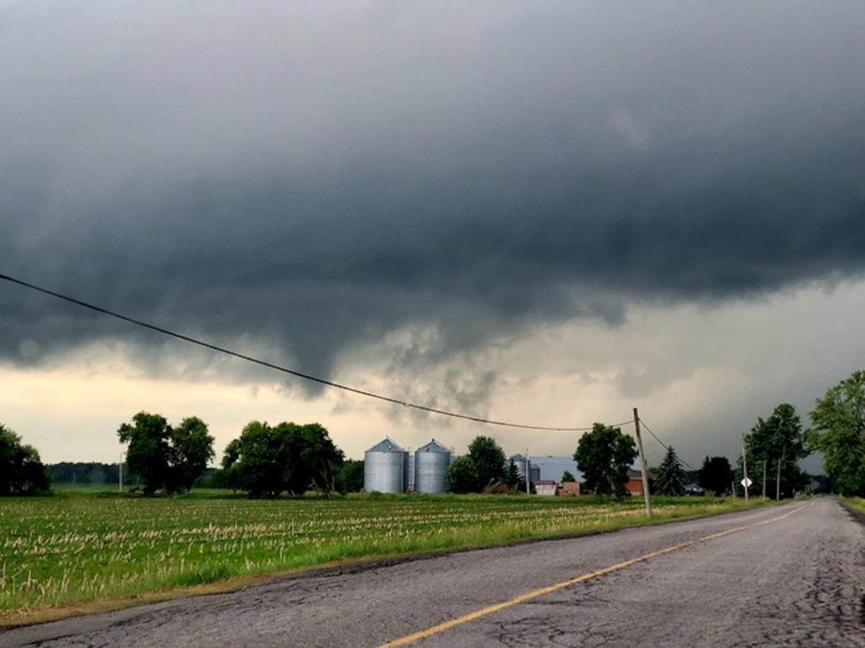
"Oh boy" might be a bit overstated, but the rotation on this line had me worried for a moment. Just south of Tweed earlier today. @weathernetwork #onstorm pic.twitter.com/PMki6UQhNN
“Oh boy” might be a bit overstated, but the rotation on this line had me worried for a moment. Just south of Tweed earlier today. Mark Robinson on Twitter: ""Oh boy" might be a bit overstated, but the rotation on this line had me worried for a moment. Just south of Tweed earlier today. @weathernetwork #onstorm pic.twitter.com/PMki6UQhNN / Twitter" Mark Robinson on Twitter: ""Oh boy" might be a bit overstated, but the rotation on this line had me worried for a moment. Just south of Tweed earlier today. @weathernetwork #onstorm pic.twitter.com/PMki6UQhNN / Twitter" Mark Robinson on Twitter: ""Oh boy" might be a bit overstated, but the rotation on this line had me worried for a moment. Just south of Tweed earlier today. @weathernetwork #onstorm pic.twitter.com/PMki6UQhNN / Twitter"
— Mark Robinson (@StormhunterTWN) Mark Robinson on Twitter: ""Oh boy" might be a bit overstated, but the rotation on this line had me worried for a moment. Just south of Tweed earlier today. @weathernetwork #onstorm pic.twitter.com/PMki6UQhNN / Twitter"
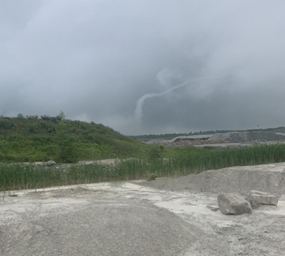
Just me or does this look like a tornado forming? #onstorm pic.twitter.com/nMwuH7DzJp
Just me or does this look like a tornado forming? Karen on Twitter: "Just me or does this look like a tornado forming? #onstorm pic.twitter.com/nMwuH7DzJp / Twitter" Karen on Twitter: "Just me or does this look like a tornado forming? #onstorm pic.twitter.com/nMwuH7DzJp / Twitter"
— Karen (@KarenfromKaren) Karen on Twitter: "Just me or does this look like a tornado forming? #onstorm pic.twitter.com/nMwuH7DzJp / Twitter"
@StormhunterTWN hubby captured this at 3:30pm heading south on 21, between 83 &81 - Centralia #onstorm Seemed to dissipate quickly pic.twitter.com/1aBznXVSqA
Cath Bossenberry on Twitter: "@StormhunterTWN hubby captured this at 3:30pm heading south on 21, between 83 &81 - Centralia #onstorm Seemed to dissipate quickly pic.twitter.com/1aBznXVSqA / Twitter" hubby captured this at 3:30pm heading south on 21, between 83 &81 - Centralia Cath Bossenberry on Twitter: "@StormhunterTWN hubby captured this at 3:30pm heading south on 21, between 83 &81 - Centralia #onstorm Seemed to dissipate quickly pic.twitter.com/1aBznXVSqA / Twitter" Seemed to dissipate quickly Cath Bossenberry on Twitter: "@StormhunterTWN hubby captured this at 3:30pm heading south on 21, between 83 &81 - Centralia #onstorm Seemed to dissipate quickly pic.twitter.com/1aBznXVSqA / Twitter"
— Cath Bossenberry (@BossenberryCath) Cath Bossenberry on Twitter: "@StormhunterTWN hubby captured this at 3:30pm heading south on 21, between 83 &81 - Centralia #onstorm Seemed to dissipate quickly pic.twitter.com/1aBznXVSqA / Twitter"
onstorm #onwx east of Palmerston On 2:30pm pic.twitter.com/nKcMGZZxO0
Kirk MacDonald on Twitter: "#onstorm #onwx east of Palmerston On 2:30pm pic.twitter.com/nKcMGZZxO0 / Twitter" Kirk MacDonald on Twitter: "#onstorm #onwx east of Palmerston On 2:30pm pic.twitter.com/nKcMGZZxO0 / Twitter" east of Palmerston On 2:30pm Kirk MacDonald on Twitter: "#onstorm #onwx east of Palmerston On 2:30pm pic.twitter.com/nKcMGZZxO0 / Twitter"
— Kirk MacDonald (@KirkMacDonald5) Kirk MacDonald on Twitter: "#onstorm #onwx east of Palmerston On 2:30pm pic.twitter.com/nKcMGZZxO0 / Twitter"
onstorm #Ottawa Tornado warning!!! I caught a meso spinning pic.twitter.com/AgazN5f6gI
GamezCapital on Twitter: "#onstorm #Ottawa Tornado warning!!! I caught a meso spinning pic.twitter.com/AgazN5f6gI / Twitter" GamezCapital on Twitter: "#onstorm #Ottawa Tornado warning!!! I caught a meso spinning pic.twitter.com/AgazN5f6gI / Twitter" Tornado warning!!! I caught a meso spinning GamezCapital on Twitter: "#onstorm #Ottawa Tornado warning!!! I caught a meso spinning pic.twitter.com/AgazN5f6gI / Twitter"
— GamezCapital (@cyclone_kid3) GamezCapital on Twitter: "#onstorm #Ottawa Tornado warning!!! I caught a meso spinning pic.twitter.com/AgazN5f6gI / Twitter"
Lots of action in ottawa today! This is storm #3 and I can start to hear another develop. #Ottawa #onstorm pic.twitter.com/BIVGWIu8uK
Lots of action in ottawa today! This is storm #3 and I can start to hear another develop. Evan Finch on Twitter: "Lots of action in ottawa today! This is storm #3 and I can start to hear another develop. #Ottawa #onstorm pic.twitter.com/BIVGWIu8uK / Twitter" Evan Finch on Twitter: "Lots of action in ottawa today! This is storm #3 and I can start to hear another develop. #Ottawa #onstorm pic.twitter.com/BIVGWIu8uK / Twitter" Evan Finch on Twitter: "Lots of action in ottawa today! This is storm #3 and I can start to hear another develop. #Ottawa #onstorm pic.twitter.com/BIVGWIu8uK / Twitter"
— Evan Finch (@evan_finch) Evan Finch on Twitter: "Lots of action in ottawa today! This is storm #3 and I can start to hear another develop. #Ottawa #onstorm pic.twitter.com/BIVGWIu8uK / Twitter"
WATCH: Tornado-warned storms bring hail and heavy rain to Ontario and Quebec
In tweed and the winds are ripping branches off the trees. Eeeep. @weathernetwork #onstorm pic.twitter.com/YqpBo7TN2F
In tweed and the winds are ripping branches off the trees. Eeeep. Mark Robinson on Twitter: "In tweed and the winds are ripping branches off the trees. Eeeep. @weathernetwork #onstorm pic.twitter.com/YqpBo7TN2F / Twitter" Mark Robinson on Twitter: "In tweed and the winds are ripping branches off the trees. Eeeep. @weathernetwork #onstorm pic.twitter.com/YqpBo7TN2F / Twitter" Mark Robinson on Twitter: "In tweed and the winds are ripping branches off the trees. Eeeep. @weathernetwork #onstorm pic.twitter.com/YqpBo7TN2F / Twitter"
— Mark Robinson (@StormhunterTWN) Mark Robinson on Twitter: "In tweed and the winds are ripping branches off the trees. Eeeep. @weathernetwork #onstorm pic.twitter.com/YqpBo7TN2F / Twitter"
Came home to find some good size hail. 1 to 1 and a half inches. Colborne, Ontario #onstorm #onwx #shareyourweather @ECCCWeatherON @weathernetwork pic.twitter.com/SnFt9ZdcUe
Came home to find some good size hail. 1 to 1 and a half inches.
Colborne, Ontario Chris Knox Photography on Twitter: "Came home to find some good size hail. 1 to 1 and a half inches. Colborne, Ontario #onstorm #onwx #shareyourweather @ECCCWeatherON @weathernetwork pic.twitter.com/SnFt9ZdcUe / Twitter" Chris Knox Photography on Twitter: "Came home to find some good size hail. 1 to 1 and a half inches. Colborne, Ontario #onstorm #onwx #shareyourweather @ECCCWeatherON @weathernetwork pic.twitter.com/SnFt9ZdcUe / Twitter" Chris Knox Photography on Twitter: "Came home to find some good size hail. 1 to 1 and a half inches. Colborne, Ontario #onstorm #onwx #shareyourweather @ECCCWeatherON @weathernetwork pic.twitter.com/SnFt9ZdcUe / Twitter" Chris Knox Photography on Twitter: "Came home to find some good size hail. 1 to 1 and a half inches. Colborne, Ontario #onstorm #onwx #shareyourweather @ECCCWeatherON @weathernetwork pic.twitter.com/SnFt9ZdcUe / Twitter" Chris Knox Photography on Twitter: "Came home to find some good size hail. 1 to 1 and a half inches. Colborne, Ontario #onstorm #onwx #shareyourweather @ECCCWeatherON @weathernetwork pic.twitter.com/SnFt9ZdcUe / Twitter" Chris Knox Photography on Twitter: "Came home to find some good size hail. 1 to 1 and a half inches. Colborne, Ontario #onstorm #onwx #shareyourweather @ECCCWeatherON @weathernetwork pic.twitter.com/SnFt9ZdcUe / Twitter"— Chris Knox Photography (@ChrisKnoxPhotog) Chris Knox Photography on Twitter: "Came home to find some good size hail. 1 to 1 and a half inches. Colborne, Ontario #onstorm #onwx #shareyourweather @ECCCWeatherON @weathernetwork pic.twitter.com/SnFt9ZdcUe / Twitter"
Here was the squall line earlier today as it rolled through the west end of Toronto - you can see it was mainly elevated with little surface interaction at the time, but it was spiking out a ton of lightning.#ONstorm pic.twitter.com/cKjB4MnBPo
Here was the squall line earlier today as it rolled through the west end of Toronto - you can see it was mainly elevated with little surface interaction at the time, but it was spiking out a ton of lightning.Tom Stef on Twitter: "Here was the squall line earlier today as it rolled through the west end of Toronto - you can see it was mainly elevated with little surface interaction at the time, but it was spiking out a ton of lightning.#ONstorm pic.twitter.com/cKjB4MnBPo / Twitter" Tom Stef on Twitter: "Here was the squall line earlier today as it rolled through the west end of Toronto - you can see it was mainly elevated with little surface interaction at the time, but it was spiking out a ton of lightning.#ONstorm pic.twitter.com/cKjB4MnBPo / Twitter"
Core of a cell in Ottawa. #onstorm pic.twitter.com/C0EM1hN2kU
Core of a cell in Ottawa. Zachery Addo on Twitter: "Core of a cell in Ottawa. #onstorm pic.twitter.com/C0EM1hN2kU / Twitter" Zachery Addo on Twitter: "Core of a cell in Ottawa. #onstorm pic.twitter.com/C0EM1hN2kU / Twitter"
— Zachery Addo (@ZacheryAddo) Zachery Addo on Twitter: "Core of a cell in Ottawa. #onstorm pic.twitter.com/C0EM1hN2kU / Twitter"
Quick timelapse of the storm as it rolled toward Carp and into Kanata North. #onstorm pic.twitter.com/19sKK4SxmI
Quick timelapse of the storm as it rolled toward Carp and into Kanata North. Matt Day on Twitter: "Quick timelapse of the storm as it rolled toward Carp and into Kanata North. #onstorm pic.twitter.com/19sKK4SxmI / Twitter" Matt Day on Twitter: "Quick timelapse of the storm as it rolled toward Carp and into Kanata North. #onstorm pic.twitter.com/19sKK4SxmI / Twitter"
— Matt Day (@mattdaymedia) Matt Day on Twitter: "Quick timelapse of the storm as it rolled toward Carp and into Kanata North. #onstorm pic.twitter.com/19sKK4SxmI / Twitter"
Thumbnail image courtesy of Kyler, taken in Richmond, Ont.

