
PHOTOS: Scary shelf and scud clouds cover Ontario as storms roll in
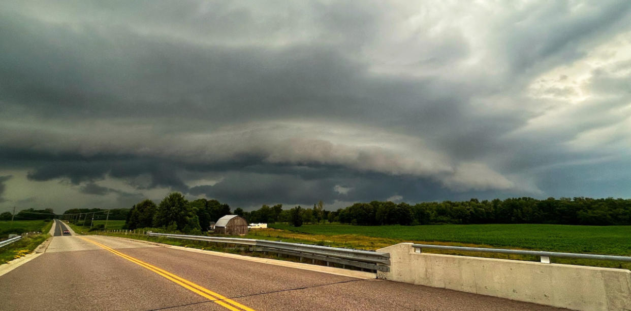
A line of thunderstorms that bubbled up ahead of a cold front Tuesday afternoon led to some striking images of shelf and scud clouds as they pushed through the region.
Storms that developed were scattered along the front, putting on a scenic show for many. Not all regions saw a thunderstorm, but many regions were put under severe thunderstorm watches as conditions were favourable.
SEE ALSO: How the atmosphere bakes a perfect thunderstorm

Shelf cloud near Brussels, Ont. (Mark Robinson/The Weather Network)
Those that did see storms faced the standard threats, and more than a handful of them reached severe limits, prompting warnings from Environment and Climate Change Canada (ECCC). In addition to the scary-looking clouds, there were several reports of hail, blustery wind gusts, frequent lightning, and even some crop and tree damage.
Come Wednesday, the storm threat will return for some. A warm front will slowly lift through the day, with rain showers returning across the southwest, including Windsor. Light sleepers should be aware, as Wednesday could feature some overnight rumbles of thunder as the system reaches the Greater Toronto Area. Continuing its movement northeast, another cold front could trigger stronger afternoon storms across the Golden Horseshoe.
It didn't take long for visuals of the fast-moving storms to surface on social media. Below is a selection of what is currently making the rounds.
Inflow notch feature north of Stratford, ON #ONstorm 03:47 PM https://t.co/lsXtrynOVi pic.twitter.com/Qf0Qcc64hy
Inflow notch feature north of Stratford, ON Travis Farncombe on Twitter: "Inflow notch feature north of Stratford, ON #ONstorm 03:47 PM https://t.co/lsXtrynOVi pic.twitter.com/Qf0Qcc64hy / Twitter" 03:47 PM Travis Farncombe on Twitter: "Inflow notch feature north of Stratford, ON #ONstorm 03:47 PM https://t.co/lsXtrynOVi pic.twitter.com/Qf0Qcc64hy / Twitter" Travis Farncombe on Twitter: "Inflow notch feature north of Stratford, ON #ONstorm 03:47 PM https://t.co/lsXtrynOVi pic.twitter.com/Qf0Qcc64hy / Twitter"
— Travis Farncombe (@tjfarncombe) Travis Farncombe on Twitter: "Inflow notch feature north of Stratford, ON #ONstorm 03:47 PM https://t.co/lsXtrynOVi pic.twitter.com/Qf0Qcc64hy / Twitter"
Significant tree and crop damage just south of Sebringville!!! Numerous large trees snapped, some at the base. Some trees have had most of their limbs stripped clean off. Several corn fields flattened. Estimate 120+kmh. #ONStorm @ECCCWeatherON @NTP_Reports pic.twitter.com/vtDkxG3Buv
Significant tree and crop damage just south of Sebringville!!! Numerous large trees snapped, some at the base. Some trees have had most of their limbs stripped clean off. Several corn fields flattened. Estimate 120+kmh. David Piano on Twitter: "Significant tree and crop damage just south of Sebringville!!! Numerous large trees snapped, some at the base. Some trees have had most of their limbs stripped clean off. Several corn fields flattened. Estimate 120+kmh. #ONStorm @ECCCWeatherON @NTP_Reports pic.twitter.com/vtDkxG3Buv / Twitter" David Piano on Twitter: "Significant tree and crop damage just south of Sebringville!!! Numerous large trees snapped, some at the base. Some trees have had most of their limbs stripped clean off. Several corn fields flattened. Estimate 120+kmh. #ONStorm @ECCCWeatherON @NTP_Reports pic.twitter.com/vtDkxG3Buv / Twitter" David Piano on Twitter: "Significant tree and crop damage just south of Sebringville!!! Numerous large trees snapped, some at the base. Some trees have had most of their limbs stripped clean off. Several corn fields flattened. Estimate 120+kmh. #ONStorm @ECCCWeatherON @NTP_Reports pic.twitter.com/vtDkxG3Buv / Twitter" David Piano on Twitter: "Significant tree and crop damage just south of Sebringville!!! Numerous large trees snapped, some at the base. Some trees have had most of their limbs stripped clean off. Several corn fields flattened. Estimate 120+kmh. #ONStorm @ECCCWeatherON @NTP_Reports pic.twitter.com/vtDkxG3Buv / Twitter"
Around Bayfield 223pm #onstorm #onwx #shareyourweather beautiful shelf @StormhunterTWN pic.twitter.com/M09tgFQOIp
Around Bayfield 223pm Timothy Ponepal on Twitter: "Around Bayfield 223pm #onstorm #onwx #shareyourweather beautiful shelf @StormhunterTWN pic.twitter.com/M09tgFQOIp / Twitter" Timothy Ponepal on Twitter: "Around Bayfield 223pm #onstorm #onwx #shareyourweather beautiful shelf @StormhunterTWN pic.twitter.com/M09tgFQOIp / Twitter" Timothy Ponepal on Twitter: "Around Bayfield 223pm #onstorm #onwx #shareyourweather beautiful shelf @StormhunterTWN pic.twitter.com/M09tgFQOIp / Twitter" beautiful shelf Timothy Ponepal on Twitter: "Around Bayfield 223pm #onstorm #onwx #shareyourweather beautiful shelf @StormhunterTWN pic.twitter.com/M09tgFQOIp / Twitter" Timothy Ponepal on Twitter: "Around Bayfield 223pm #onstorm #onwx #shareyourweather beautiful shelf @StormhunterTWN pic.twitter.com/M09tgFQOIp / Twitter"
— Timothy Ponepal (@TJsupercell) Timothy Ponepal on Twitter: "Around Bayfield 223pm #onstorm #onwx #shareyourweather beautiful shelf @StormhunterTWN pic.twitter.com/M09tgFQOIp / Twitter"
Very strong storm in Kitchener now, so much thunder! #onwx #onstorm pic.twitter.com/d4esIjMbn1
Very strong storm in Kitchener now, so much thunder! SpaceCat on Twitter: "Very strong storm in Kitchener now, so much thunder! #onwx #onstorm pic.twitter.com/d4esIjMbn1 / Twitter" SpaceCat on Twitter: "Very strong storm in Kitchener now, so much thunder! #onwx #onstorm pic.twitter.com/d4esIjMbn1 / Twitter" SpaceCat on Twitter: "Very strong storm in Kitchener now, so much thunder! #onwx #onstorm pic.twitter.com/d4esIjMbn1 / Twitter"
— SpaceCat (@sassy_gonzalez) SpaceCat on Twitter: "Very strong storm in Kitchener now, so much thunder! #onwx #onstorm pic.twitter.com/d4esIjMbn1 / Twitter"
A few favourite shots from today's @HighwaysHail #onstorm ⚡️chase between Seaforth & Tavistock. Some pretty structure (initially) for a marginal/slight-risk day. Fun to get out again! pic.twitter.com/5OTkPQYfuC
A few favourite shots from today's Travis Farncombe on Twitter: "A few favourite shots from today's @HighwaysHail #onstorm ⚡️chase between Seaforth & Tavistock. Some pretty structure (initially) for a marginal/slight-risk day. Fun to get out again! pic.twitter.com/5OTkPQYfuC / Twitter" Travis Farncombe on Twitter: "A few favourite shots from today's @HighwaysHail #onstorm ⚡️chase between Seaforth & Tavistock. Some pretty structure (initially) for a marginal/slight-risk day. Fun to get out again! pic.twitter.com/5OTkPQYfuC / Twitter" ⚡️chase between Seaforth & Tavistock. Some pretty structure (initially) for a marginal/slight-risk day. Fun to get out again! Travis Farncombe on Twitter: "A few favourite shots from today's @HighwaysHail #onstorm ⚡️chase between Seaforth & Tavistock. Some pretty structure (initially) for a marginal/slight-risk day. Fun to get out again! pic.twitter.com/5OTkPQYfuC / Twitter"
— Travis Farncombe (@tjfarncombe) Travis Farncombe on Twitter: "A few favourite shots from today's @HighwaysHail #onstorm ⚡️chase between Seaforth & Tavistock. Some pretty structure (initially) for a marginal/slight-risk day. Fun to get out again! pic.twitter.com/5OTkPQYfuC / Twitter"
Yipe. Hail and very strong winds in there. South of Stratford. @weathernetwork #ONStorm pic.twitter.com/kG4ikPa1Rg
Yipe. Hail and very strong winds in there. South of Stratford. Mark Robinson on Twitter: "Yipe. Hail and very strong winds in there. South of Stratford. @weathernetwork #ONStorm pic.twitter.com/kG4ikPa1Rg / Twitter" Mark Robinson on Twitter: "Yipe. Hail and very strong winds in there. South of Stratford. @weathernetwork #ONStorm pic.twitter.com/kG4ikPa1Rg / Twitter" Mark Robinson on Twitter: "Yipe. Hail and very strong winds in there. South of Stratford. @weathernetwork #ONStorm pic.twitter.com/kG4ikPa1Rg / Twitter"
— Mark Robinson (@StormhunterTWN) Mark Robinson on Twitter: "Yipe. Hail and very strong winds in there. South of Stratford. @weathernetwork #ONStorm pic.twitter.com/kG4ikPa1Rg / Twitter"
WATCH: Heavy rainfall and scary clouds accompany storms in southern Ontario
More damage pics all in same vicinity as my earlier reports. My photos represent a small fraction of the overall tree and crop damage I drove past. Wasn't able to stop on busy roads but the severe damage continued to just south of Stratford! #onstorm @ECCCWeatherON @NTP_Reports pic.twitter.com/DUUgbFWykF
More damage pics all in same vicinity as my earlier reports. My photos represent a small fraction of the overall tree and crop damage I drove past. Wasn't able to stop on busy roads but the severe damage continued to just south of Stratford! David Piano on Twitter: "More damage pics all in same vicinity as my earlier reports. My photos represent a small fraction of the overall tree and crop damage I drove past. Wasn't able to stop on busy roads but the severe damage continued to just south of Stratford! #onstorm @ECCCWeatherON @NTP_Reports pic.twitter.com/DUUgbFWykF / Twitter" David Piano on Twitter: "More damage pics all in same vicinity as my earlier reports. My photos represent a small fraction of the overall tree and crop damage I drove past. Wasn't able to stop on busy roads but the severe damage continued to just south of Stratford! #onstorm @ECCCWeatherON @NTP_Reports pic.twitter.com/DUUgbFWykF / Twitter" David Piano on Twitter: "More damage pics all in same vicinity as my earlier reports. My photos represent a small fraction of the overall tree and crop damage I drove past. Wasn't able to stop on busy roads but the severe damage continued to just south of Stratford! #onstorm @ECCCWeatherON @NTP_Reports pic.twitter.com/DUUgbFWykF / Twitter" David Piano on Twitter: "More damage pics all in same vicinity as my earlier reports. My photos represent a small fraction of the overall tree and crop damage I drove past. Wasn't able to stop on busy roads but the severe damage continued to just south of Stratford! #onstorm @ECCCWeatherON @NTP_Reports pic.twitter.com/DUUgbFWykF / Twitter"
Lambeth #onstorm pic.twitter.com/1Wj36ngScZ
Lambeth J. Brown on Twitter: "Lambeth #onstorm pic.twitter.com/1Wj36ngScZ / Twitter" J. Brown on Twitter: "Lambeth #onstorm pic.twitter.com/1Wj36ngScZ / Twitter"
— J. Brown (@kingkuley) J. Brown on Twitter: "Lambeth #onstorm pic.twitter.com/1Wj36ngScZ / Twitter"
Still sitting in the inflow near Stratford, but the shelf is looking more disorganized and elevated than before. @weathernetwork #ONStorm pic.twitter.com/U72kNTsXA2
Still sitting in the inflow near Stratford, but the shelf is looking more disorganized and elevated than before. Mark Robinson on Twitter: "Still sitting in the inflow near Stratford, but the shelf is looking more disorganized and elevated than before. @weathernetwork #ONStorm pic.twitter.com/U72kNTsXA2 / Twitter" Mark Robinson on Twitter: "Still sitting in the inflow near Stratford, but the shelf is looking more disorganized and elevated than before. @weathernetwork #ONStorm pic.twitter.com/U72kNTsXA2 / Twitter" Mark Robinson on Twitter: "Still sitting in the inflow near Stratford, but the shelf is looking more disorganized and elevated than before. @weathernetwork #ONStorm pic.twitter.com/U72kNTsXA2 / Twitter"
— Mark Robinson (@StormhunterTWN) Mark Robinson on Twitter: "Still sitting in the inflow near Stratford, but the shelf is looking more disorganized and elevated than before. @weathernetwork #ONStorm pic.twitter.com/U72kNTsXA2 / Twitter"
Taken at my house in #miltonontario right now. Lotsa lightning & thunder & a bit of hail. @KMacTWN @weathernetwork @StormhunterTWN @AnthonyFarnell @KelseyMcEwen pic.twitter.com/oKrESCPGbz
Taken at my house in Lois Eibl 💙 on Twitter: "Taken at my house in #miltonontario right now. Lotsa lightning & thunder & a bit of hail. @KMacTWN @weathernetwork @StormhunterTWN @AnthonyFarnell @KelseyMcEwen pic.twitter.com/oKrESCPGbz / Twitter" right now. Lotsa lightning & thunder & a bit of hail. Lois Eibl 💙 on Twitter: "Taken at my house in #miltonontario right now. Lotsa lightning & thunder & a bit of hail. @KMacTWN @weathernetwork @StormhunterTWN @AnthonyFarnell @KelseyMcEwen pic.twitter.com/oKrESCPGbz / Twitter" Lois Eibl 💙 on Twitter: "Taken at my house in #miltonontario right now. Lotsa lightning & thunder & a bit of hail. @KMacTWN @weathernetwork @StormhunterTWN @AnthonyFarnell @KelseyMcEwen pic.twitter.com/oKrESCPGbz / Twitter" Lois Eibl 💙 on Twitter: "Taken at my house in #miltonontario right now. Lotsa lightning & thunder & a bit of hail. @KMacTWN @weathernetwork @StormhunterTWN @AnthonyFarnell @KelseyMcEwen pic.twitter.com/oKrESCPGbz / Twitter" Lois Eibl 💙 on Twitter: "Taken at my house in #miltonontario right now. Lotsa lightning & thunder & a bit of hail. @KMacTWN @weathernetwork @StormhunterTWN @AnthonyFarnell @KelseyMcEwen pic.twitter.com/oKrESCPGbz / Twitter" Lois Eibl 💙 on Twitter: "Taken at my house in #miltonontario right now. Lotsa lightning & thunder & a bit of hail. @KMacTWN @weathernetwork @StormhunterTWN @AnthonyFarnell @KelseyMcEwen pic.twitter.com/oKrESCPGbz / Twitter" Lois Eibl 💙 on Twitter: "Taken at my house in #miltonontario right now. Lotsa lightning & thunder & a bit of hail. @KMacTWN @weathernetwork @StormhunterTWN @AnthonyFarnell @KelseyMcEwen pic.twitter.com/oKrESCPGbz / Twitter"
— Lois Eibl 💙 (@fraueibl) Lois Eibl 💙 on Twitter: "Taken at my house in #miltonontario right now. Lotsa lightning & thunder & a bit of hail. @KMacTWN @weathernetwork @StormhunterTWN @AnthonyFarnell @KelseyMcEwen pic.twitter.com/oKrESCPGbz / Twitter"
Rain, wind and hail in Newmarket. #ONStorm pic.twitter.com/1as8bcRsNY
Rain, wind and hail in Newmarket. Maria D on Twitter: "Rain, wind and hail in Newmarket. #ONStorm pic.twitter.com/1as8bcRsNY / Twitter" Maria D on Twitter: "Rain, wind and hail in Newmarket. #ONStorm pic.twitter.com/1as8bcRsNY / Twitter"
— Maria D (@mariaDadd) Maria D on Twitter: "Rain, wind and hail in Newmarket. #ONStorm pic.twitter.com/1as8bcRsNY / Twitter"

