
PHOTOS: Wild Ontario winter storm knocks out power, thundersnow reported
A powerful winter storm pounding the Great Lakes region brought thundersnow and blizzard-like conditions to much of southern Ontario to end the week.
Travel was nearly impossible at times throughout the region as the skies opened up with copious amounts of snow and wicked wind gusts of 50-80+ km/h, which led to near-whiteout conditions at times.
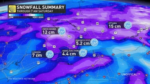
Through 7 a.m. Saturday morning, this is how much snowfall was reported across some select cities: London saw 7 cm, Hamilton received 4.4 cm, Toronto accumulated 5.2 cm, Owen Sound observed 12 cm and Ottawa documented 15 cm.
Folks across the region witnessed unmistakable blue and white flashes of lightning filling the sky on Friday evening, a testament to the raw power of the low-pressure system as it passed by. Lightning was seen striking the CN Tower in downtown Toronto.
An unstable atmosphere, a fast-strengthening low-pressure system, and winds blowing off the lake can all combine to create the lift and instability needed to generate thundersnow. Heavy snowfall rates can accompany the flashes of lightning and sharp, rolling bursts of thunder.
Tens of thousands of homes and businesses across southern Ontario lost power late Friday evening due to the heavy snow and blustery winds. Hydro One's website reported more than 30,000 outages during the height of the storm.
Dozens of scheduled arrivals and departures into and out of Toronto-Pearson International Airport through Saturday morning are delayed or cancelled due to the storm. Check with your airline for the latest updates as this storm continues across the region.
See the powerful storm at its height and its messy aftermath across Ontario in photos and videos, below.
This is all going to be ice soon. Grab a shovel instead of coffee this morning and curse my name as you drag the snowy slop out of your driveway. You may actually thank me for this advice later ... 😉 @weathernetwork #ONStorm pic.twitter.com/UIWYJXXhCp
This is all going to be ice soon. Grab a shovel instead of coffee this morning and curse my name as you drag the snowy slop out of your driveway. You may actually thank me for this advice later … 😉 Mark Robinson on Twitter: "This is all going to be ice soon. Grab a shovel instead of coffee this morning and curse my name as you drag the snowy slop out of your driveway. You may actually thank me for this advice later ... 😉 @weathernetwork #ONStorm pic.twitter.com/UIWYJXXhCp / Twitter" Mark Robinson on Twitter: "This is all going to be ice soon. Grab a shovel instead of coffee this morning and curse my name as you drag the snowy slop out of your driveway. You may actually thank me for this advice later ... 😉 @weathernetwork #ONStorm pic.twitter.com/UIWYJXXhCp / Twitter" Mark Robinson on Twitter: "This is all going to be ice soon. Grab a shovel instead of coffee this morning and curse my name as you drag the snowy slop out of your driveway. You may actually thank me for this advice later ... 😉 @weathernetwork #ONStorm pic.twitter.com/UIWYJXXhCp / Twitter"
— Mark Robinson (@StormhunterTWN) Mark Robinson on Twitter: "This is all going to be ice soon. Grab a shovel instead of coffee this morning and curse my name as you drag the snowy slop out of your driveway. You may actually thank me for this advice later ... 😉 @weathernetwork #ONStorm pic.twitter.com/UIWYJXXhCp / Twitter"
High winds damaged a pole and brought down a hydro line across Dundas Street west of Walkers Line in Burlington earlier. Over 1700 area residents were without power for a period of time, now down to 485. #BurlON #ONStorm pic.twitter.com/IY9shp5rxl
High winds damaged a pole and brought down a hydro line across Dundas Street west of Walkers Line in Burlington earlier. Over 1700 area residents were without power for a period of time, now down to 485. DR on Twitter: "High winds damaged a pole and brought down a hydro line across Dundas Street west of Walkers Line in Burlington earlier. Over 1700 area residents were without power for a period of time, now down to 485. #BurlON #ONStorm pic.twitter.com/IY9shp5rxl / Twitter" DR on Twitter: "High winds damaged a pole and brought down a hydro line across Dundas Street west of Walkers Line in Burlington earlier. Over 1700 area residents were without power for a period of time, now down to 485. #BurlON #ONStorm pic.twitter.com/IY9shp5rxl / Twitter" DR on Twitter: "High winds damaged a pole and brought down a hydro line across Dundas Street west of Walkers Line in Burlington earlier. Over 1700 area residents were without power for a period of time, now down to 485. #BurlON #ONStorm pic.twitter.com/IY9shp5rxl / Twitter"
Scenery from Barrie. Courtesy of my friend, Stephanie. Curious to see more photos from Lake Simcoe area. Downtown Oakville has seen a lot of mixing and just straight rain, alongside some snow, so totals are on the lighter side. Pretty tame compared to elsewhere. #ONstorm #ONwx pic.twitter.com/VswVRBmd1r
Scenery from Barrie. Courtesy of my friend, Stephanie. Curious to see more photos from Lake Simcoe area. Downtown Oakville has seen a lot of mixing and just straight rain, alongside some snow, so totals are on the lighter side. Pretty tame compared to elsewhere. Nathan Howes TWN on Twitter: "Scenery from Barrie. Courtesy of my friend, Stephanie. Curious to see more photos from Lake Simcoe area. Downtown Oakville has seen a lot of mixing and just straight rain, alongside some snow, so totals are on the lighter side. Pretty tame compared to elsewhere. #ONstorm #ONwx pic.twitter.com/VswVRBmd1r / Twitter" Nathan Howes TWN on Twitter: "Scenery from Barrie. Courtesy of my friend, Stephanie. Curious to see more photos from Lake Simcoe area. Downtown Oakville has seen a lot of mixing and just straight rain, alongside some snow, so totals are on the lighter side. Pretty tame compared to elsewhere. #ONstorm #ONwx pic.twitter.com/VswVRBmd1r / Twitter" Nathan Howes TWN on Twitter: "Scenery from Barrie. Courtesy of my friend, Stephanie. Curious to see more photos from Lake Simcoe area. Downtown Oakville has seen a lot of mixing and just straight rain, alongside some snow, so totals are on the lighter side. Pretty tame compared to elsewhere. #ONstorm #ONwx pic.twitter.com/VswVRBmd1r / Twitter"
Video of #thundersnow in Downtown Toronto, hitting the CN Tower. 2 consectutive years capturing it! #ONStorm pic.twitter.com/YofTbhDxZU
Video of SCJ Weather on Twitter: "Video of #thundersnow in Downtown Toronto, hitting the CN Tower. 2 consectutive years capturing it! #ONStorm pic.twitter.com/YofTbhDxZU / Twitter" in Downtown Toronto, hitting the CN Tower. 2 consectutive years capturing it! SCJ Weather on Twitter: "Video of #thundersnow in Downtown Toronto, hitting the CN Tower. 2 consectutive years capturing it! #ONStorm pic.twitter.com/YofTbhDxZU / Twitter" SCJ Weather on Twitter: "Video of #thundersnow in Downtown Toronto, hitting the CN Tower. 2 consectutive years capturing it! #ONStorm pic.twitter.com/YofTbhDxZU / Twitter"
— SCJ Weather (@SCJWeather) SCJ Weather on Twitter: "Video of #thundersnow in Downtown Toronto, hitting the CN Tower. 2 consectutive years capturing it! #ONStorm pic.twitter.com/YofTbhDxZU / Twitter"
Pearson airport 😮 #ONStorm pic.twitter.com/9YVYK8ovAT
Pearson airport 😮 Hussein E on Twitter: "Pearson airport 😮 #ONStorm pic.twitter.com/9YVYK8ovAT / Twitter" Hussein E on Twitter: "Pearson airport 😮 #ONStorm pic.twitter.com/9YVYK8ovAT / Twitter"
— Hussein E (@therealhebrahim) Hussein E on Twitter: "Pearson airport 😮 #ONStorm pic.twitter.com/9YVYK8ovAT / Twitter"
WATCH: Kitchener prepares for a winter storm showdown
I have the unique perspective of tonight's #ONStorm from my west-facing 8th-floor balcony. The winds are hitting from the east, allowing me to witness the snowfall in comfort. I can't say the same for the guy walking his dog or the person driving by.Stay safe.. 🌨️💨🥶 pic.twitter.com/87FI8M9zjh
I have the unique perspective of tonight's Granny.. 🇨🇦 on Twitter: "I have the unique perspective of tonight's #ONStorm from my west-facing 8th-floor balcony. The winds are hitting from the east, allowing me to witness the snowfall in comfort. I can't say the same for the guy walking his dog or the person driving by.Stay safe.. 🌨️💨🥶 pic.twitter.com/87FI8M9zjh / Twitter" from my west-facing 8th-floor balcony. The winds are hitting from the east, allowing me to witness the snowfall in comfort. I can't say the same for the guy walking his dog or the person driving by.
Stay safe.. 🌨️💨🥶 Granny.. 🇨🇦 on Twitter: "I have the unique perspective of tonight's #ONStorm from my west-facing 8th-floor balcony. The winds are hitting from the east, allowing me to witness the snowfall in comfort. I can't say the same for the guy walking his dog or the person driving by.Stay safe.. 🌨️💨🥶 pic.twitter.com/87FI8M9zjh / Twitter"
@TorontoPearson right now #ONStorm pic.twitter.com/quO8HrwSAI
Silvio on Twitter: "@TorontoPearson right now #ONStorm pic.twitter.com/quO8HrwSAI / Twitter" right now Silvio on Twitter: "@TorontoPearson right now #ONStorm pic.twitter.com/quO8HrwSAI / Twitter" Silvio on Twitter: "@TorontoPearson right now #ONStorm pic.twitter.com/quO8HrwSAI / Twitter"
— Silvio (@binge_aviation) Silvio on Twitter: "@TorontoPearson right now #ONStorm pic.twitter.com/quO8HrwSAI / Twitter"
Big, wet flakes coming down in #HamOnt. Wind has died down considerably-for now. #ShareYourWeather @weathernetwork pic.twitter.com/OEPa97E1zJ
Big, wet flakes coming down in Matthew Di Nicolantonio, TWN on Twitter: "Big, wet flakes coming down in #HamOnt. Wind has died down considerably-for now. #ShareYourWeather @weathernetwork pic.twitter.com/OEPa97E1zJ / Twitter". Wind has died down considerably—for now. Matthew Di Nicolantonio, TWN on Twitter: "Big, wet flakes coming down in #HamOnt. Wind has died down considerably-for now. #ShareYourWeather @weathernetwork pic.twitter.com/OEPa97E1zJ / Twitter" Matthew Di Nicolantonio, TWN on Twitter: "Big, wet flakes coming down in #HamOnt. Wind has died down considerably-for now. #ShareYourWeather @weathernetwork pic.twitter.com/OEPa97E1zJ / Twitter" Matthew Di Nicolantonio, TWN on Twitter: "Big, wet flakes coming down in #HamOnt. Wind has died down considerably-for now. #ShareYourWeather @weathernetwork pic.twitter.com/OEPa97E1zJ / Twitter"
— Matthew Di Nicolantonio, TWN (@dinicTWN) Matthew Di Nicolantonio, TWN on Twitter: "Big, wet flakes coming down in #HamOnt. Wind has died down considerably-for now. #ShareYourWeather @weathernetwork pic.twitter.com/OEPa97E1zJ / Twitter"
My view while writing. 🫠#ONStorm pic.twitter.com/Gb7KI90ITg
My view while writing. 🫠Charlie on Twitter: "My view while writing. 🫠#ONStorm pic.twitter.com/Gb7KI90ITg / Twitter" Charlie on Twitter: "My view while writing. 🫠#ONStorm pic.twitter.com/Gb7KI90ITg / Twitter"
— Charlie (@SlugWolf0506) Charlie on Twitter: "My view while writing. 🫠#ONStorm pic.twitter.com/Gb7KI90ITg / Twitter"
Loud thunder and lighting with snow coming down fast. Strong winds as well. What a crazy weather night! #OnStorm pic.twitter.com/18birAiNsV
Loud thunder and lighting with snow coming down fast. Strong winds as well. What a crazy weather night! Emily Szabo on Twitter: "Loud thunder and lighting with snow coming down fast. Strong winds as well. What a crazy weather night! #OnStorm pic.twitter.com/18birAiNsV / Twitter" Emily Szabo on Twitter: "Loud thunder and lighting with snow coming down fast. Strong winds as well. What a crazy weather night! #OnStorm pic.twitter.com/18birAiNsV / Twitter"
— Emily Szabo (@emilysradio) Emily Szabo on Twitter: "Loud thunder and lighting with snow coming down fast. Strong winds as well. What a crazy weather night! #OnStorm pic.twitter.com/18birAiNsV / Twitter"
Literally 5 minutes ago the heavy flakes started coming down. Kitchener Ontario @weathernetwork @KMacTWN @StormhunterTWN @MurphTWN @Lyndsay_CTV @CTVKitchener @CTVNews @RachelSchoutsen @nadinehp4 #ONstorm #onstorm #winter2024 #stormwarning #kitchener #ontario pic.twitter.com/Q7wz14CWEY
Literally 5 minutes ago the heavy flakes started coming down. Kitchener Ontario Crosswind Nature on Twitter: "Literally 5 minutes ago the heavy flakes started coming down. Kitchener Ontario @weathernetwork @KMacTWN @StormhunterTWN @MurphTWN @Lyndsay_CTV @CTVKitchener @CTVNews @RachelSchoutsen @nadinehp4 #ONstorm #onstorm #winter2024 #stormwarning #kitchener #ontario pic.twitter.com/Q7wz14CWEY / Twitter" Crosswind Nature on Twitter: "Literally 5 minutes ago the heavy flakes started coming down. Kitchener Ontario @weathernetwork @KMacTWN @StormhunterTWN @MurphTWN @Lyndsay_CTV @CTVKitchener @CTVNews @RachelSchoutsen @nadinehp4 #ONstorm #onstorm #winter2024 #stormwarning #kitchener #ontario pic.twitter.com/Q7wz14CWEY / Twitter" Crosswind Nature on Twitter: "Literally 5 minutes ago the heavy flakes started coming down. Kitchener Ontario @weathernetwork @KMacTWN @StormhunterTWN @MurphTWN @Lyndsay_CTV @CTVKitchener @CTVNews @RachelSchoutsen @nadinehp4 #ONstorm #onstorm #winter2024 #stormwarning #kitchener #ontario pic.twitter.com/Q7wz14CWEY / Twitter" Crosswind Nature on Twitter: "Literally 5 minutes ago the heavy flakes started coming down. Kitchener Ontario @weathernetwork @KMacTWN @StormhunterTWN @MurphTWN @Lyndsay_CTV @CTVKitchener @CTVNews @RachelSchoutsen @nadinehp4 #ONstorm #onstorm #winter2024 #stormwarning #kitchener #ontario pic.twitter.com/Q7wz14CWEY / Twitter" Crosswind Nature on Twitter: "Literally 5 minutes ago the heavy flakes started coming down. Kitchener Ontario @weathernetwork @KMacTWN @StormhunterTWN @MurphTWN @Lyndsay_CTV @CTVKitchener @CTVNews @RachelSchoutsen @nadinehp4 #ONstorm #onstorm #winter2024 #stormwarning #kitchener #ontario pic.twitter.com/Q7wz14CWEY / Twitter" Crosswind Nature on Twitter: "Literally 5 minutes ago the heavy flakes started coming down. Kitchener Ontario @weathernetwork @KMacTWN @StormhunterTWN @MurphTWN @Lyndsay_CTV @CTVKitchener @CTVNews @RachelSchoutsen @nadinehp4 #ONstorm #onstorm #winter2024 #stormwarning #kitchener #ontario pic.twitter.com/Q7wz14CWEY / Twitter" Crosswind Nature on Twitter: "Literally 5 minutes ago the heavy flakes started coming down. Kitchener Ontario @weathernetwork @KMacTWN @StormhunterTWN @MurphTWN @Lyndsay_CTV @CTVKitchener @CTVNews @RachelSchoutsen @nadinehp4 #ONstorm #onstorm #winter2024 #stormwarning #kitchener #ontario pic.twitter.com/Q7wz14CWEY / Twitter" Crosswind Nature on Twitter: "Literally 5 minutes ago the heavy flakes started coming down. Kitchener Ontario @weathernetwork @KMacTWN @StormhunterTWN @MurphTWN @Lyndsay_CTV @CTVKitchener @CTVNews @RachelSchoutsen @nadinehp4 #ONstorm #onstorm #winter2024 #stormwarning #kitchener #ontario pic.twitter.com/Q7wz14CWEY / Twitter" Crosswind Nature on Twitter: "Literally 5 minutes ago the heavy flakes started coming down. Kitchener Ontario @weathernetwork @KMacTWN @StormhunterTWN @MurphTWN @Lyndsay_CTV @CTVKitchener @CTVNews @RachelSchoutsen @nadinehp4 #ONstorm #onstorm #winter2024 #stormwarning #kitchener #ontario pic.twitter.com/Q7wz14CWEY / Twitter" Crosswind Nature on Twitter: "Literally 5 minutes ago the heavy flakes started coming down. Kitchener Ontario @weathernetwork @KMacTWN @StormhunterTWN @MurphTWN @Lyndsay_CTV @CTVKitchener @CTVNews @RachelSchoutsen @nadinehp4 #ONstorm #onstorm #winter2024 #stormwarning #kitchener #ontario pic.twitter.com/Q7wz14CWEY / Twitter" Crosswind Nature on Twitter: "Literally 5 minutes ago the heavy flakes started coming down. Kitchener Ontario @weathernetwork @KMacTWN @StormhunterTWN @MurphTWN @Lyndsay_CTV @CTVKitchener @CTVNews @RachelSchoutsen @nadinehp4 #ONstorm #onstorm #winter2024 #stormwarning #kitchener #ontario pic.twitter.com/Q7wz14CWEY / Twitter" Crosswind Nature on Twitter: "Literally 5 minutes ago the heavy flakes started coming down. Kitchener Ontario @weathernetwork @KMacTWN @StormhunterTWN @MurphTWN @Lyndsay_CTV @CTVKitchener @CTVNews @RachelSchoutsen @nadinehp4 #ONstorm #onstorm #winter2024 #stormwarning #kitchener #ontario pic.twitter.com/Q7wz14CWEY / Twitter" Crosswind Nature on Twitter: "Literally 5 minutes ago the heavy flakes started coming down. Kitchener Ontario @weathernetwork @KMacTWN @StormhunterTWN @MurphTWN @Lyndsay_CTV @CTVKitchener @CTVNews @RachelSchoutsen @nadinehp4 #ONstorm #onstorm #winter2024 #stormwarning #kitchener #ontario pic.twitter.com/Q7wz14CWEY / Twitter" Crosswind Nature on Twitter: "Literally 5 minutes ago the heavy flakes started coming down. Kitchener Ontario @weathernetwork @KMacTWN @StormhunterTWN @MurphTWN @Lyndsay_CTV @CTVKitchener @CTVNews @RachelSchoutsen @nadinehp4 #ONstorm #onstorm #winter2024 #stormwarning #kitchener #ontario pic.twitter.com/Q7wz14CWEY / Twitter" Crosswind Nature on Twitter: "Literally 5 minutes ago the heavy flakes started coming down. Kitchener Ontario @weathernetwork @KMacTWN @StormhunterTWN @MurphTWN @Lyndsay_CTV @CTVKitchener @CTVNews @RachelSchoutsen @nadinehp4 #ONstorm #onstorm #winter2024 #stormwarning #kitchener #ontario pic.twitter.com/Q7wz14CWEY / Twitter" Crosswind Nature on Twitter: "Literally 5 minutes ago the heavy flakes started coming down. Kitchener Ontario @weathernetwork @KMacTWN @StormhunterTWN @MurphTWN @Lyndsay_CTV @CTVKitchener @CTVNews @RachelSchoutsen @nadinehp4 #ONstorm #onstorm #winter2024 #stormwarning #kitchener #ontario pic.twitter.com/Q7wz14CWEY / Twitter"
WATCH: Be aware of your heart while shovelling this year
Thumbnail courtesy of Mike Bertrand, taken in Milton, Ont.

