
Post-Thanksgiving snow threatens to put skids on travel in Midwest

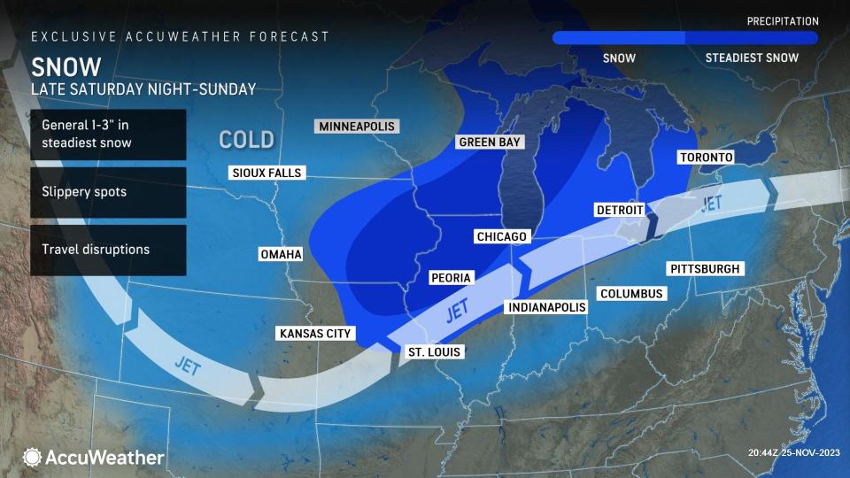


The same storm that unloaded 1-2 feet of snow on the Rockies from Thursday into Friday will pivot across the Midwest with winterlike travel conditions in store for a large swath of the central United States on Sunday, AccuWeather meteorologists warn. The season's first widespread and significant lake-effect snow will follow the storm early this week.
Even though the storm was at its peak whilst over the Rockies, it will manage to pull in some moisture from the Gulf of Mexico and produce accumulating snow to Illinois and Michigan.
A storm that impacted the Plains will continue to move along, causing snow to fall across a large part of the Midwest, mainly during the day on Sunday.
 |
A general 1 to 3 inches of snow will fall from Illinois and southern Wisconsin to the Lower Peninsula of Michigan, northern Indiana and northwestern Ohio. Portions of northern Illinois and southern Wisconsin will be most likely to see the heaviest snow, and perhaps as much as 3 or 4 inches. Temperatures will likely hover near or just above freezing in the Midwest as the snow falls, which will be enough to make for mainly wet travel as opposed to snow-packed roads.
Still, motorists in the Midwest should be on the lookout for slushy and slippery spots, which can occur just about anywhere but may be more common in hilly areas outside of the downtown areas of major cities such as Chicago and Detroit. At the very least, the snow will lead to poor visibility on the highways with blowing spray from other vehicles.
The falling snow will accumulate on grassy and elevated surfaces, including on the wings of some aircraft. This means that de-icing operations will be required at the airports and may contribute to airline delays amid the post-Thanksgiving surge in travel.
Mostly rain will fall from the southern Plains to the mid-Mississippi Valley and in the Ohio Valley from the storm. Some areas near Interstate 44 in Missouri and near and north of I-70 in the Ohio Valley may have a mixture of rain, sleet and wet snow.
 |
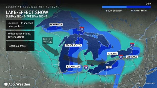
Areas in the Midwest that were made wet and slushy by the snow from Sunday will tend to freeze as temperatures dip Sunday night. This can lead to sheets of ice that may be hard to distinguish from wet surfaces.
While a couple of flurries are possible around Minneapolis on Sunday, accumulating snow from this storm will pass by to the southeast of the Twin Cities.
The Midwest storm, a second storm near New England and a third storm from southern Canada will join up over Ontario and Quebec from Sunday night to Monday. This merge will cause winds to increase and cold air to be reinforced over the Upper Midwest.
From Sunday night to Tuesday, winds will howl around the Great Lakes with frequent gusts from the west and northwest ranging between 35 and 45 mph and perhaps some as high as 55 mph. The winds will lead to overwash along the windward shorelines.
The combination will trigger not only a penetrating gusty wind in the region, but as the cold air passes over the open waters of the Great Lakes, bringing the first significant lake-effect event of the season.
 |
The potential exists for locally very heavy lake-effect snow from parts of northern Wisconsin and northern Michigan to western and the northern Lower Peninsula of Michigan, northwestern Indiana, northeastern Ohio, northwestern Pennsylvania and western, central and northern New York state.
Want next-level safety, ad-free? Unlock advanced, hyperlocal severe weather alerts when you subscribe to Premium+ on the AccuWeather app. AccuWeather Alerts™ are prompted by our expert meteorologists who monitor and analyze dangerous weather risks 24/7 to keep you and your family safer.
