
Potentially damaging winds smack Ontario after historic warmth
Folks across southern Ontario are enjoying a remarkable stretch of historic November warmth this Saturday, but a cold front racing across the Great Lakes will crash the party in a hurry. Watch out for potentially damaging wind gusts as we head through the overnight hours. Tree damage and power outages are possible.
We’re watching a low-pressure system pull north across the Great Lakes this weekend. Southerly winds ahead of the low sent exceptionally warm temperatures surging across southern portions of Ontario and Quebec.
FALL BACK TONIGHT: These great tips can help you adjust to tonight’s time change

Toronto appears to have recorded its warmest day in November history on Saturday, with a high temperature of 25.1°C beating the previous all-time monthly high temperature of an even 25°C set in 1950 and tied in 1961.
St. Catharines peaked at about 26°C on Saturday afternoon, coming within a degree or so of tying the warmest November temperature ever recorded in all of Canada.
This is some advanced, summer-like warmth in November. Extremes beget extremes, unfortunately, and the same system that brought the warmth will also rake the region with strong winds.
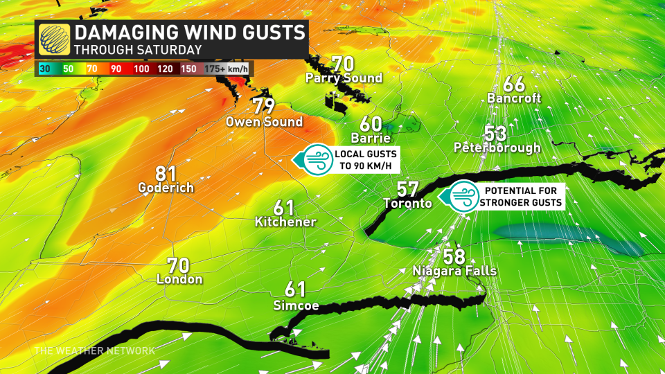
A cold front associated with that low trekking across the Great Lakes will sweep over southern Ontario through Saturday night. Strong winds aloft will mix down to the surface along and behind that cold front, leading to a period of potentially damaging wind gusts.
Gusts could exceed 80 km/h in spots, especially in communities above the escarpment. However, gusts that strong can’t be ruled out in the Greater Toronto Area. We could see even stronger winds closer to the centre of the low, with parts of the Bruce Peninsula potentially in line for gusts as strong as 90 km/h.
DON’T MISS: It’s not your imagination—here’s why fall is the foggiest season
Watch out for falling trees and power lines during periods of high winds. Take a moment to secure any loose objects outdoors that could blow around in the gusty conditions—especially any remaining Halloween decorations that could catch the wind like sails.

Our cold front will reach eastern Ontario and southern Quebec by Sunday morning. Though the front will be noticeably weaker than it was when it hit southern Ontario on Saturday, we’ll still see breezy conditions across the region to close out the weekend.
Temperatures will remain above-seasonal through early week, with conditions briefly returning to near-seasonal on Tuesday and Wednesday. We’ll see warmer temperatures creep back into the region by the end of the week ahead of a potential Colorado low heading toward the eastern Prairies.

