
The Prairies are bracing for winter wallop with 30 cm of snow possible
November will waste no time in giving the Prairies another glimpse of winter, with a potent storm set to push through portions of the region this week. A sizable area stretching from southern Alberta to northern Manitoba will be on the hook for 10-30 cm of snow. As a result, drivers can expect significant travel impacts and possible power outages through late week. More on the timing of this system and when the widespread snow will fly, below.
RELATED: Why the first snowfall of the season can catch drivers by surprise
This week: Heavy snow, dangerous travel takes aim across all Prairie provinces
Snowfall warnings are in effect in northern and southern Alberta, where the heavy snow will fall Tuesday into Wednesday. More alerts are likely to be issued on Tuesday as the precipitation begins to push east.
"Consider postponing non-essential travel until conditions improve. Visibility may be suddenly reduced at times in heavy snow. Take frequent breaks and avoid strain when clearing snow," Environment and Climate Change Canada (ECCC) says in the warning.
By Wednesday morning, widespread light snow, with possibly higher snowfall rates in the foothills and southern Alberta, will be falling in a widespread swath across Alberta, central Saskatchewan and into northern Manitoba as well.
The snow, coupled with gusty winds, could lead to difficult travel on major routes across southern Alberta Wednesday morning. With reduced visibility expected, it's best to plan for a slower commute in the Calgary and surrounding areas.

The snow will begin to ease across Alberta on Thursday, though continuing for Saskatchewan and Manitoba through the afternoon hours. The system will then pull east out of the Prairies by Thursday evening.
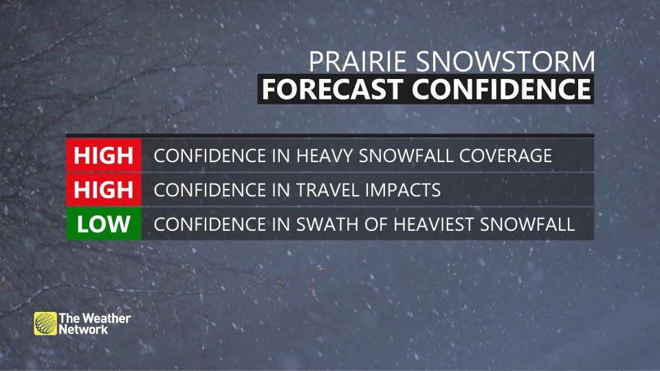
Snowfall confidence
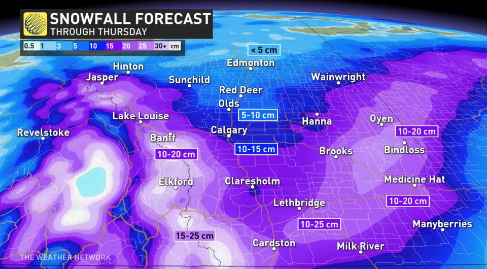
At this point, 10-30 of snow is expected cm along foothills, with the heaviest amounts expected in higher elevations. Southern portions of Alberta may crack 20+ cm. A good 10-20 cm of snow is anticipated along an axis from southern Alberta to northern Manitoba. Calgary is within the 5-15 cm range but trending towards to higher end. Lethbridge and Medicine Hat, Alta., may approach 20 cm of snow.
Thumbnail courtesy of Darren Howard.
Be sure to check back for the latest on conditions across the Prairies

