
East Coast braces for far-reaching storm, potentially damaging winds
A powerful low-pressure system developing over New England will move into the western Maritimes shortly, pushing heavy precipitation and warm air along its path.
While the precipitation will be an issue, more so for some areas, it's the winds that will be most problematic and disruptive.
Going somewhere? Check out the current highway conditions before heading out!
Gusts are expected to reach or exceed 100 km/h Monday afternoon along the coastal sections of the Maritimes, so the potential for widespread power outages is elevated. Make sure your devices are charged before then, and also, ensure all outdoor items are securely tied down or stored away inside.

Damage to buildings, such as to roof shingles and windows, may occur. Utility outages may occur.
A wide range of weather alerts are in place for Atlantic Canada, from wind and rainfall warnings to winter storm watches and special weather statements.
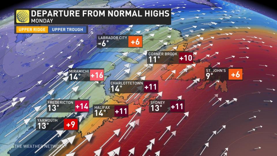
Southerly winds usher in warmth before powerful storm arrives
The precipitation will begin Sunday evening across New Brunswick, with the heaviest rain happening Monday morning. The current track of the storm is bringing the heaviest rain through central and northern New Brunswick, where up to 80 mm will fall. Eastern sections could see 30-50 mm of rain. General totals of 10-30 mm are expected across the rest of the Maritimes.

But it’s not the rain that’ll make this storm noteworthy or dangerous. The same moisture-packed, southerly winds feeding those heavy rains will bring warm temperatures and powerful wind gusts to the region through the day Monday.
Daytime highs will climb well into the mid-teens for most of the Maritimes on Monday. Readings will climb as high as 15°C in Truro, N.S., which is well above seasonal for the middle of December.
DON’T MISS: Staying safe during a power outage
Temperatures growing that warm around this time of year is usually an ominous sign, and the winds transporting that warm air won’t arrive peacefully.
Winds will steadily increase in intensity across the Maritimes through the day Monday, peaking through the afternoon and evening hours. A strong, low-level jet stream sweeps across the region.
Wind gusts up to 110 km/h will develop by Monday afternoon along coastal sections of the Maritimes.
The coverage and intensity of these high winds will likely damage trees and power lines throughout the region, leading to scattered power outages across the three provinces.

Ensure any outdoor holiday decorations are well-secured or brought inside before the winds begin. Inflatable characters and lightweight decor can take flight in winds half this strong, potentially causing damage, injuries, or even car accidents.
Remain mindful of large trees or tree limbs looming over homes, roads, and driveways, and take care to avoid those areas during the highest winds. Most wind-related injuries are caused by trees falling into buildings or vehicles.
We’ll see the winds calm down Monday overnight, though conditions will remain blustery across Newfoundland into Tuesday.
Temperatures will cool abruptly behind the cold front with strong winds that will make it feel much chillier. Conditions will remain around or just below seasonal for the remainder of the week.
Stay with The Weather Network for all the latest on your forecast across Atlantic Canada.

