
Thunderstorm risk creeps into Ontario as potent storm starts April

It’s a powerful spring storm with a wintry flavour, and it’ll swing right over Ontario as we begin April.
A stark divide slicing through the province will separate continued heavy snows to the north from heavy rain and even the risk for a rogue severe storm or two across the south.
This unsettled pattern will continue straight into the first week of April, with a potentially significant warmup on tap by next week.
GET THE LATEST: Violent tornadoes tear across U.S. during high-risk severe outbreak
This low is strengthening in a hurry as it approaches the Great Lakes region. It’s such a dynamic system that it’s producing a rare, high-end severe weather outbreak across the U.S., with multiple violent tornadoes reported during the day Friday.
Threat for up to 40 cm of snow by Saturday for northern Ontario
The transition zone between rain and snow will roughly follow the track of the low as it cuts into Ontario, extending from Sault Ste. Marie to North Bay. Winter storm warnings are in effect for the region.
The first wave of snow arrived during the day Friday, with the second wave continuing overnight and into midday Saturday.

The heavy snow and gusty winds will lead to low visibility on roads at the height of the storm. Travel will be significantly impacted throughout the region, including along stretches of the Trans-Canada Highway.
Storm totals of 20-40 cm of snow will spread from the eastern shores of Lake Superior to the Quebec border. If you are within that zone from Wawa through Sault Ste. Marie to Sudbury, and from Timmins to Kirkland Lake down to North Bay, expect heavy snowfall and difficult travel.
LEARN MORE: A cavalcade of Colorado lows can send Canada’s forecast into upheaval
Heavy rains, risk of thunderstorms for southern Ontario
Precipitation that arrived in southern and central Ontario on Friday will grow heavier through the nighttime hours
A steady, drenching rain will leave behind widespread totals of 20-30 mm in the gauges by the end of the storm on Saturday, with 30-40 mm possible from the Bruce Peninsula southward to London. Gusty winds will also accompany the rain and warmer temperatures.
Southwesterly winds of 50-70+ km/h will whip through southern Ontario heading into the day Saturday. Areas adjacent to the lake shores will be a little stronger. The combination of gusty winds and wet soils could lead to localized tree damage and power outages.
SPRING SAFETY: 5 all-natural products to keep ticks at bay
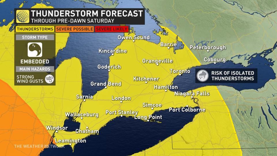
This low also brings with it the risk of thunderstorms, a true sign that spring is indeed here (for some at least).
A risk for storms will encompass most of southern Ontario through the pre-dawn hours on Saturday, with a storm risk continuing along the 401 corridor between Windsor and Montreal, including the Greater Toronto Area, during the day Saturday.

Severe thunderstorms are even possible just south of the border, potentially spilling into far eastern sections of the Niagara Peninsula. Any stronger storms on Saturday could produce strong wind gusts.
If you've got errands to run, Saturday morning is likely your best bet as there will be a brief break in the rain before showers resume late morning to early afternoon.
WATCH: Ontario becomes front runner for first 20° in Canada
Saturday will be one of those odd days where it’s warmer in the morning than it is in the evening, with temperatures in the low teens falling into the single digits by late afternoon and early evening.
As the system departs Saturday evening, there could be a few quick flurries over higher terrain north and west of the GTA.

Calmer and cooler conditions will prevail behind the storm by Sunday.
An active pattern with changeable temperatures is expected to continue through the first week of April however, as a few more significant systems track across the region. For some areas, the warm temperatures on Saturday could be a preview of what’s ahead next week.
Be sure to check back for the latest weather updates across Ontario.

